Suffolk Coast Path - Orford to Butley Ferry
|
Saturday 29 December 2018
|
No comments |
![]()

A 6.5 mile Suffolk circular walk along the banks of the Ore and Butley rivers between Orford and the Butley Ferry river crossing at Gedgrave.
The Suffolk Coast Path Orford Loop has two routes back onto the main trail, the first returns from Orford up to Chillesford but an alternative is to follow the lane from Orford to Gedrgrave and down to Butley Ferry. Although this crossing only operates from April to October, a pleasant and easy circular walk can be made from Orford returning along the top of the river defences.
The Suffolk Coast Path to Butley Ferry - Essential Information
Walk Statistics:
- Start location: Orford
- Distance: miles ( km)
- Total Gain: ft ( metre)
- Total Descent: ft ( metre)
- Min Height: ft ( metre)
- Max Height: ft ( metre)
- Walk Time:
- Walk type: Circular
- Walk Grade: Easy
- Terrain:
Maps:
The following maps and services can assist in navigating this route. There are links to printed maps and links to downloadable GPX route data for importing into navigational software and apps.
- Ordnance Survey Explorer Map
- OS Explorer 212 - Woodbridge & Saxmundham
- GPX Route File
Route Verification Details
- Date of Walk: 2011-11-19
- Walk Time: 11:30 to 15:30
- Walkers: Griffmonster, Kat
- Weather Conditions: Lovely sunny winters day
Walk Notes
This is a circular walk going out from Orford village to an area generally known as Gedgrave that these days is little more than farmland and marsh. There are reminders of such a parish, which has now been amalgamated into the Orford Parish. Gedgrave Hall exists and is located on the right of the lane that this walk uses to reach the Butley River. These days the Hall is part of the Gedgrave Estate, a farming concern owned by the Greenwell family who were originally from Durham and who bought the land and Hall in the 1930s. The area of the Hall is also where the parish church of St Andrew once stood. This was built some time before AD1171 and was employed as a Vicarage to Butley Priory. Nothing remains of the church with it falling into disrepair after the Dissolution, the ruins then being dismantled sometime around 1550 although there is a report of some remains in the 17th century when six skeletons were reputedly found on the site.
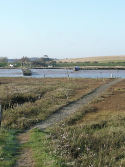
The lane continues down to the river, accessed along a very sandy track to Ferry Cottages. A ferry has existed at this location since the 16th century and is reputedly one of the oldest ferry crossings in Britain. The 20th century saw its demise when modern transport made it obsolete. However in recent years the ferry has been revived by volunteers and offers a weekend and bank holiday service from Easter until October, providing a valuable resource for both walkers and cyclists alike.
The Butley River is also renowned for its oyster beds with evidence showing that they existed during the post medieval period although there are some suggestions that oyster pits existed here in medieval times. Such early evidence is difficult to establish as the area has been extensively changed with land reclamation and defence bank works since the 13th century. An elderly lady whom I spoke to some time ago in the Plough and Sail at Snape Maltings informed me that she had lived all her life in Orford and that the tracks down to Butley Creek are paved with centuries of oyster shells. I have certainly not found this to be the case on the main track down to the river which is nothing but soft sand although I may not have been looking in the correct location as she was not very specific. These days oyster farming is still in operation and the Ferry cottages beside the river employ a smokehouse owned and constructed by Pinneys of Orford where the catch from the river is smoked using whole oak logs, the results which are then used in their Orford shop and restaurant. Beside the smokehouse are stacks of lobster pots presenting a pleasing site to passers by and one that may have been the same many centuries ago.
On the opposite side of the river is Burrow Hill, once an island in the salt marsh of the tidal river. There is evidence that the hill contained Saxon burials from the 8th century with possible earlier settlement. It is also suggested the hill may have been used as a staging post for monks from Butley Priory crossing the river on their journeys to Orford.
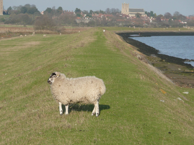
From the Ferry cottages, a footpath runs along the defence banks and a sign informs the walker that this is a licensed footpath. A little research reveals that this designation is the same as a permissive footpath, which is a publicly accessible path across private land at the landowners discretion. This path is not marked on the OS map but there are clear waymarkers from Butley Ferry along the well maintained path atop of the flood defences with numerous self-closing latch gates to keep the sheep contained.
The licensed path joins a public footpath just before the defence banks turns out towards Chantry Point at the head of the Chantry Marshes. This is a curious name as it implies some kind of monastic derivation although there is no sign of any Chantry construction and the marshes are all post medieval reclaimed land.
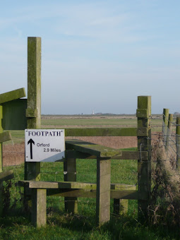
The public footpath is part of the Orford Loop section of the Suffolk Coast Path which offers either the route across Butley Ferry or paths to Chillesford where it joins the main trail. The Suffolk Loop is not well advertised although its distinctive yellow and blue waymarkers can be found throughout the route that leads down from Iken to Orford.
Directions
The route takes a mixture of tracks, public and licenced footpaths, following the official Suffolk Coast Path along part of the route.
Take the Gedgrave Road out of Orford, and keep to the lane for nearly 2 miles until the way ahead becomes a private road and a track on the right leads leads down to Ferry Cottage. Turn left along the river bank defences and the ferry is a hundred yards down river. To continue back to Orford, take the gate onward from the ferry, which is marked as a licensed path. This follows the river bank back to the public right of way at Chantry Marshes, and then on into Orford.
The official Suffolk Coast Path heads inland to Gedgrave Road at Chantry marshes, where the licensed path joins the public footpath.
Pubs
The Jolly Sailor, Orford View in OS Map | View in Google Map
- Address
- Quay Street, Orford
- Website
- https://www.jollysailororford.co.uk/
Charming 16th century pub on Quay Street in Orford offering freshly caught fish landed at Orford Quay and home smoked hams and hand made sausages and a full compliment of Adnams ales. An array of pastimes are available including dominoes and shove-ha’penny as well as newspapers and during winter months there is a roaring log fire. A sign outside the pub advertises 'Children, Dogs, Parrots and Horse are welcome, humans by appointment!' Legend has it that the pub was built from the timbers of wrecked ships and is said to have been a smugglers haunt. A 'wanted' poster for an escaped lady horse-thief is displayed on the walls of the pub. This was a certain 18-year-old Margaret Catchpole whom was captured at the pub and subsequently transported to Australia. Accommodation available as well as a campsite amidst the orchard at the rear of the pub.

Features
Butley FerryView in OS Map | View in Google Map
The Butley ferry links Gedgrave and Butley across Butley Creek and is operated by the Alde and Ore Association. This volunteer rowing boat ferry operates on weekends and bank holidays between Easter and the end of September.
Alongside the jetty, there is a notice board with details of the natural habitats and information about the ferry. This includes the following brief history:
Historically there has been a ferry operating at Butley since at least the end of the 16th century. Landowner Robert Forth employed a ferryman who lived next to the river and, at the time, there was free passage for pedestrians.
In 1632 Robert Forths grandson, William, sold the lease of the ferry, ferry house and land for £300. The land was valuable as it included sheep pasture along the river walls. The amount paid indicated outside investors, who employed local men to run the ferry and farm.
In later years the Smith family ran the ferry for almost a century. When George Smith was run over by a wagon in 1897, his widow, who was left with 10 children, had to row the ferry herself. She was not the first woman to do so, a century earlier another widow Lydia Gunnell operated the ferry.
Jane Connard who holidayed at Ferry Farm in 1914 recalled that the "ferry rarely functioned - the ferryman was constantly in and out of jail". The ferry stopped operating in 1932.
In recent years, the ferry service has been revived.
References
Burrow HillView in OS Map | View in Google Map
On the Butley side of the Butley River is a conspicuous hill known as Burrow Hill. Local legend states that this hill is a burial mound covering a ship and a Danish king surrounded by his treasures and weapons. Valerie Fenwick excavated part of the hill in 1978, revealing 8th century iron working and an Anglo-Saxon cemetery but no royal treasures were found. The graves were all of men, so it may be the monastic site.
St Andrews Church, GedgraveView in OS Map | View in Google Map
Although there are is nothing to mark the site, the church of St Andrews in Gedgrave was believed to have been on the left hand side of the Gedgrave road, towards the end of this lane. The church was established prior to 1171 and it is thought to have been a vicarage to Butley priory. By the 16th century it had fallen into disrepair after the dissolution of the monasteries and was eventually completely dismantled around the mid-1500's
Gallery
Below are a selection of images taken from from the photo album for this walk. Feel free to browse through these or click on an image to view a larger version in the Gallery.


Summary of Document Changes
Last Updated: 2021-12-07
Circular Walk, Coast Walk, Distance:Medium, Features:Ferries, Features:Local History, full-detail, OSmap:212, Suffolk, Suffolk Coast Path


0 comments:
Post a Comment