The Sandlings Walk - Knodishall to Snape
|
Saturday 15 December 2018
|
No comments |
![]()

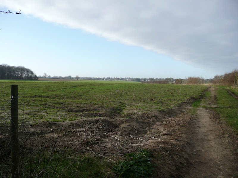
A 13 mile circular walk along the Sandlings Walk between Knodishall and Snape
With limited public transport this walk offers a circular route to incorporate the Sandlings path from Knodishall to Snape. Starting and ending at nearby Leiston it incorporates The Sailors Path and the Suffolk Coast Path to make a worthwhile day walk. The route passes Friston mill and Hall and the burial grounds where a Saxon burial ship was discovered. With pubs at Friston and Snape it provides for a great days ramble.
Sandlings Walk - Snape to Knodishall - Essential Information
Walk Statistics:
- Start location: Snape
- Distance: miles ( km)
- Total Gain: ft ( metre)
- Total Descent: ft ( metre)
- Min Height: ft ( metre)
- Max Height: ft ( metre)
- Walk Time:
- Walk type: Circular
- Walk Grade: Easy
- Terrain:
Maps:
The following maps and services can assist in navigating this route. There are links to printed maps and links to downloadable GPX route data for importing into navigational software and apps.
- Ordnance Survey Explorer Map
- OS Explorer 212 - Woodbridge & Saxmundham
- GPX Route File
Route Verification Details
- Date of Walk: 2015-04-18
- Walk Time: 09:30 to 16:00
- Walkers: Griffmonster
- Weather Conditions: Bright spring sunshine, cool but pleasant. First time in the year we had to take fleeces off!
Walk Notes
The Sandlings Walk is a long distance path in coastal Suffolk linking Ipswich and Southwold. A varied and interesting path that navigates through the traditional heath and woodland of coastal Suffolk offering a complimentary alternative to the Suffolk Coast Path. One of the principle difficulties in navigating the Sandlings Walk is the lack of public transport to perform linear rambles. Particularly in recent times when bus services have been withdrawn from the section between Aldeburgh, Snape and onwards to Woodbridge, this presents a challenge to anyone wanting to undertake specific sections of this path as day walks. Therefore a viable option is to make use of the Suffolk Coast Path and undertake each section as a circular walk. This route seeks to provide a walk for the Knodishall to Snape section.
This is an extensive circular walk and although it only manages 6 miles along the Sandlings Walk, it uses the picturesque coastal Area of Outstanding Natural Beauty to create a notable and rewarding circular route. This route incorporates the Sailors Path from Snape to Aldeburgh, part of the Suffolk Coast Path, plus footpaths along the heaths and commons of Aldringham and Thorpeness. For those who want to reduce the distance, there is a bus service that links Aldeburgh and Leiston. Alternatively, the Sandlings Walk can be followed from Aldringham to return back to Knodishall, missing out Leiston. This section is covered in the Knodishall to Sizewell Belts walk on this site.
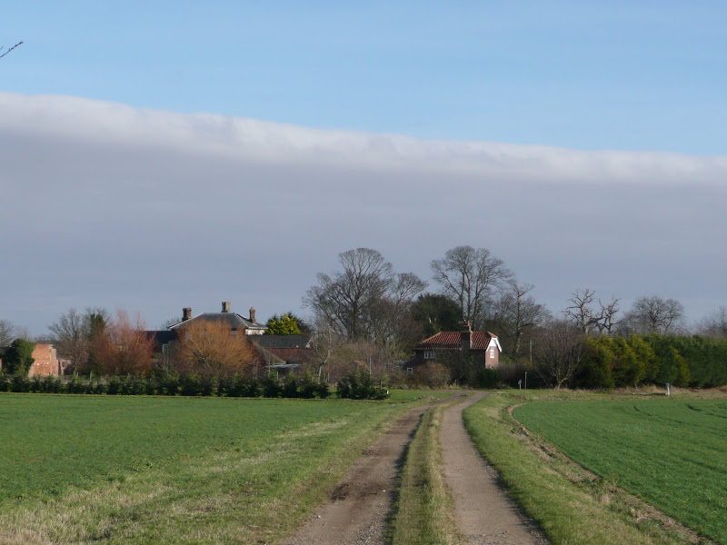
The Sandlings Walk footpath is found at the western edge of the village of Knodishall. This name is a bit of a misnomer for this village is called Coldfair Green, as displayed on the village sign that stands proudly on the green aside the The Hundred River, no more a stream and often dry during Summer months. Most local folk refer to the village as Knodishall rather than Coldfair even though it was not even in the Knodishall parish up until the 1980s, being an extremity to the Leiston parish. The western side of the village is heathland, typical of the Sandlings landscape which is sandy soil with gorse and grassland and this is known as Knodishall Common and has historically always been in that parish. The Sandlings Walk ignores this heath and uses the track that leads to the east of Bulls Hall. This crosses another track that leads from the Hall and cuts across the fields marking the boundary to what used to be heathland known as Watch Walk Whin. The track down to the Bulls Hall and onward to the road had it public access extinguished in 1949 by the National Parks And Access To The Countryside Act, 1949 and it was probably around this time that Watch Walk Whin was transformed to agricultural use. The word Whin is an old English term for gorse that is thought to derived from Scandinavian languages.
Where the track bends around to the left to head to Friston, there is a water filled pit. The Suffolk landscape is full of such pits that are the scars of marl extraction, the London Clay that had traditionally been used to fertilize the fields. However this pit may have a different history. It is not marked on OS maps other than as a small wooded area. There are lcal stories that this was the location where an aircraft came down during WWII. There are records that detail an accident in Knodishall involving a Halifax III Bomber returning from a raid over Germany in the closing stages of the war. On the night of Wednesday 21st February 1945 Bomber Command carried out a massive raid to attack various targets across Germany. The raid involved 899 aircraft with additional planes carrying out minor missions. Flight NP-Y took off at 17:26 from RAF Lissett in Yorkshire with orders to attack Worms, south west of Frankfurt. At 19:45 it came down in trees at Belfield Hall Farm in Knodishall, bursting into flames and killing five of the crew although the pilot and flight engineer survived.
The location of Belfield Hall Farm is a bit of a mystery as there is nothing around this area by that name, the closest being Billeaford Hall on the opposite side of the Knodishall road. However the Aircraft Remembered website does appear to indicate that the pit on the track to Friston is the site, marking the location on a map and describing it as 1 mile WSW of Leiston which fits the bill.
The route continues through to Friston a village whose name means 'enclosure or settlement of Frisians', the Frisians being a tribe from Northern Germany who arrived in this part of Britain after the withdrawal of the Romans in the 5th Century AD. At the point where the path leaves the road , beyond the Old Chequers pub, one can view the old Friston Mill, an impressive structure that is partially renovated (see the features below for more details). The path then heads to Friston Hall which is no more than a large farmhouse these days but stands on the site of a 16th century Manor House. Opposite the Hall is an avenue of Lime trees that leads back down to the main road. This dates from the 17th century and originally led down to a racecourse on Blackheath overlooking the Alde estuary.
The Sandlings follows the track away from the house and then takes another track known as Redbarn Lane down to Snape. Where this crosses the main road is the eastern boundary of heathland known as Church Common. These days the Common is reduced to a small section by the Snape crossroads but had once extended to both sides of the main road. There have been many archaeological finds on this ground which contains a series of Anglo-Saxon Tumuli and burial mounds and even the road, an 18th century creation, appears to have been placed directly over some of these barrows. The site was explored as early as 1826 when gold rings, brooches and chains were unearthed and subsequently the first ever Saxon boat burial was discovered here as well as shields, spears, various ornaments and vessels plus a mass of red human hair that had been wrapped up in sailcloth. A full report of this excavation can be found on The Suffolk Institute of Archaeology and History website. It makes some interesting reading and presents these unassuming fields in a completely different light and significance.
The route then leads down into Snape village where there are two pubs, The Golden Key and The Crown, both which can provide the walker with suitable refreshment before the walk back.
Return is using the Suffolk Coast Path which navigates along the river bank from Snape bridge and then up to Snape Warren, an historic area of heath and grassland that is now designated as the Snape Warren Nature Reserve. It is from here we follow the so called Sailors Path through Blackheath Woods, once the site of a horse racing track mentioned earlier, and Hazelwood Common to the Aldeburgh road. Local folklore states this path was use by sailors who would have to walk to the deeper waters at Slaughden quay when the tide made navigation along the Alde channel to Snape difficult, and hence the name of the Sailors Path. Much is made of this fact and suggestions that it was also once a renowned smugglers route in order to entice visitors to the area. It certainly is a popular walking route and during sunny skies and summer weather the path is well frequented by visitors. How authentic these stories are is open to debate. The path is certainly depicted on the early 19th century OS maps and is marked as The Sailors Path of early 20th century maps. However earlier maps fail to include it and there appear to be no documentary mentions of the path in the various 18th and 19th century travel companions and county descriptions. Nonetheless, it is a delightful route to follow and the walker will not be disappointed by it.
The route continues following the Coast Path, skirting around the western boundary of Aldeburgh, passing the Red House, the former residence of composer Benjamin Britain. We then leave the Coast Path as it passes over the former railway trackbed. This is now a permissive path that leads through to the western edge of Thorpeness. The final section cuts across Aldringham Common to return into Leiston.
Directions
The main Sandlings walk is between Snape and Knodishall. To get to Snape from Leiston either use the route below, or take the Knodishall road through to the junction with the Aldeburgh Road and continue straight on down the track to Snape.
Leiston to Snape
From Leiston take Red House Lane out of town eastwards. This turns to a track and soon afterwards there is a footpath on the right. Take this and continue through the Golf Course and onto the old railway track at Thorpeness. Keep to the track until the Suffolk Coast Path crosses this just before Aldeburgh. Take the right footpath and follow the Suffolk Coast Path waymarkers up to the road, across the Golf Course and around the back of Aldeburgh. When it meets the main road turn right and continue along the verges until the Sailors Path on the left. Keep to this through to Snape Maltings.
Snape to Knodishall
From the Maltings take the road into Snape. Turn right by the Crown pub and follow the lane up the hill, round the sharp left bend and onto the main road. Cross straight over the main road and follow the footpath along the field boundary until it junctions with a another footpath. Turn right and follow the path past the Hall, then across the lawn on the right and over the fields to Friston. turn left onto the road. At the Chequers pub cross directly over and follow the road to the left turn. A footpath on the right leads down by the side of a fence until a stile allows access to the field on the left. Diagonally cross the field to emerge onto a farm track. Keep to the track down to Knodishall.
Knodishall to Leiston
Follow the road through Knodishall and into Leiston.
Pubs
The Chequers, Friston View in OS Map | View in Google Map
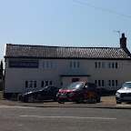
- Address
- Aldeburgh Road, Friston
- Website
- www.oldchequers.co.uk/
The Chequers probably dates from the end of the 18th century at a time when the village was expanding and there was a need for a meeting place for folk from the wider area. Records show that The Association for the Prosecution of Horse Stealers had regular meetings at the pub in the early 19th century. In recent years the inn has seen several landlords but is currently closed, the last owner quitting in October 2011.
Always a guest ale on and always in top condition.
The Crown, Snape View in OS Map | View in Google Map
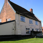
- Address
- Bridge Road, Snape
- Website
- snape-crown.co.uk/
The Crown Inn is a 15th century smugglers inn. The interior is full of old beams, original brick floors and probably the finest double Suffolk settle in existence which surrounds the inglenook fireplace. There is also a spacious garden and a varied menu offering dishes cooked from locally sourced seasonal produce including their own home reared meats and produce from the pubs own allotment. Ales are supplied by Adnams beers and there's a choice of over thirty different wines.
As it was such a lovely spring day we opted to sit outside in the enclosed garden. No complaints about the Adnams Old Ale, a glorious and easy drinking dark ale which complimented an excellent Ploughmans lunch supplied on a wooden board. A little on the expensive side but then no different from other Adnams houses in this area.
The Golden Key, Snape View in OS Map | View in Google Map

- Address
- Priory Road, Snape
- Website
- https://www.goldenkeysnape.co.uk/
This pub dates from 1480 when it was known as the sign of the Cock. The building retains its original character with exposed beams and brickwork with large open fireplaces to provide that traditional English pub feel. There is a main bar area, adjacent dining areas and a popular "drinkers grotto". Small outside patio. Classic, well cooked British food features strongly but not to the detriment of fine beer on sale.
It is easy to miss this pub, tucked away off of the main road through the village and just around the corner from the Crown. In fact I had lived in the area for many years before I realised it was there. Very busy when we visited but a decent pint of Adnams Explorer and an amusing tiff between a young couple riding their bicycles which fell over after they stood them up against the fence.

Features
Friston HallView in OS Map | View in Google Map
Friston manor was an area of land that was part of an endowment that had been made to the Benedictine house of St John at Colchester around 1155 to fund the building of the Abbey at Snape. By the late 16th century the ownership of the manor had passed to Micheal Hare of Bruisyard who then sold it on to James Bacon. It was either Hare or Bacon who built the manor house which has come to be known as Friston Hall. The Bacon family enlarged the house during the 17th century including adding a chapel to make it one of the largest houses in the county. Its estate included dove-houses, gardens, orchards, stables, decoy pool and a warren.
During the seventeenth century the great avenue of lime trees was planted. Although this still remains down to the Aldeburgh road, when constructed this road did not exist and the avenue continued all the way down to Snape Common where there was a race course. Races were held annually on August 14th after the four-day Dunningworth Horse Fair.
The house was bought by Sir Henry Johnson, a wealthy shipbuilder from Aldeburgh, in the 1680s, and he made improvements to the house and demolished the Chapel. The large iron gates bearing Johnsons initials still stand between the remains of the terrace and the kitchen garden.
The house has passed through the ownership of many generations of the Wentworth family beginning in 1711 when Thomas Wentworth married Anna Johnson, the daughter of Sir Henry. In 1947 Major Charles John Wentworth, inherited the estate through to his death in 1975. The old manor, together with the land in the parish of Hazelwood were finally offered for sale as the Blackheath Estate in 1998, ending nearly three centuries of Wentworth family ownership. Having said this, it would appear a Charles Wentworth still resides at the Hall, which is owned by BHE Farms Ltd.
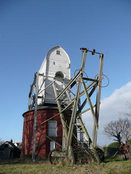
Friston MillView in OS Map | View in Google Map
The Friston Mill is a fine example of a post mill with a roundhouse. It originally had four sails and a fantail which was carried on the rear steps in the Suffolk style. It is reputed to be the tallest surviving post mill in the UK.
The date the mill was constructed was 1812, however there is debate over whether the mill was constructed in California, Ipswich and moved in sections or whether it was one of four which originally stood above Woodbridge and was moved to Friston. Either way, the mill was worked by several millers up until 1837 when it was purchased by Joshua Reynolds who eventually built the house next to the mill in 1872. A plaque displaying his name and the date still exists high on the wall of the house facing the road.
Two of the sails were removed in 1943 and not replaced due to the shortage of timber leaving the mill to work on the two remaining sails until 1956. The sails were then replaced by a diesel engine which worked up until 1964. Despite threats of demolition in 1965 and 1968 and even a proposal to move the mill to The East Anglian Rural Life Museum at Stowmarket the mill has remained in situ. Permission for demolition was finally rescinded and on the death of the last miller in 1972 when new owners declared their intention of preservation. In 2003 English Heritage donated a grant to assist with the preservation. In 2004 the steel framework was erected as the post was out of alignment and the trestle fractured and in need of urgent repair. The framework is still in place to this day and the work has yet to commence.
Summary of Document Changes
Last Updated: 2021-12-07
Circular Walk, Distance:long, Features:Churches and abbeys, Features:Mills, full-detail, OSmap:212, Sandlings, Suffolk


0 comments:
Post a Comment