A 20 mile walk along the Suffolk Coast Path between Snape and Felixstowe
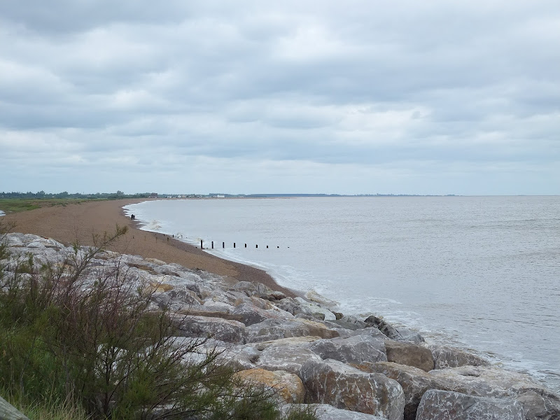
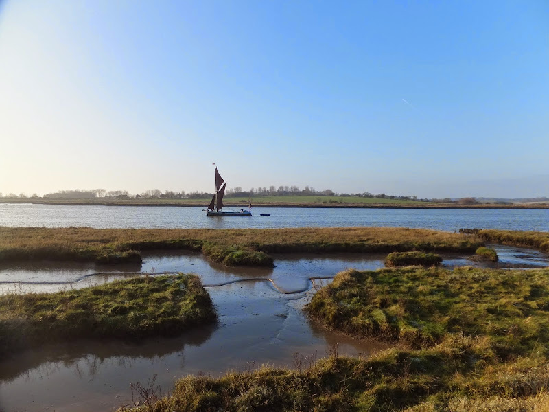
This is the most remote section of the Suffolk Coast Path and follows the Butley River down to Shingle Street and then continues along the coast to the ferry at Bawdsey. There is an eerie sense of foreboding when walking this section. The solitude. The windswept landscape. The distant silhouettes of the Orfordness Pagodas. The lonely river. One can walk virtually the entire distance without seeing a soul and the only company is the decaying remains of WWII defences and the looming martello towers from Napoleonic times.
A 10 mile alternative route for the North Norfolk Coast Path between Sheringham and Cley
This walk takes diversions from the official route of the North Norfolk Coast Path via the North Norfolk Railway and the Weybourne Priory Ruins. A further alternative is then used to navigate away from the strenuous shingle walk along the coast to a more gentle amble up to the village of Salthouse and across the hills to Cley. This provides a scenic and interesting alternative to the official route of the North Norfolk Coast Path and gives some spectacular views across the marshes from the hillside between Salthouse and Cley.
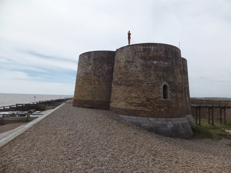
A 7 mile walk from Thorpeness to Aldeburghs Martello Tower
For a period of 12 months starting in May 2015, a life size sculpture of a human figure will look out across the sea atop Aldeburghs Martello Tower. This is the work of Anthony Gormley, the artist who is renowned for creating the iconic Angel of the North sculpture, and is part of the celebrations to mark 50 years of the Landmark Trust.
A 10 mile circular walk to witness the damage caused by the 2013 Storm Surge
The 2013 Storm Surge proved to be the highest tide in 60 years. Although much of the flooding had recede the evidence remained of where the waters reached. Viewing the changes in coastline shows just how vulnerable this stretch of the Suffolk coast really is, especially in view of the fact that such storms appear to be increasing in frequency. The walk returns through the heath and forest via Dunwich Heath and Eastbridge where the results of Octobers St Jude storm are evident from the many fallen trees.
An overview of the Suffolk Coast Path, a 60 mile long distance path following the coast of Suffolk
A 60 mile long distance footpath from Felixstowe to Lowestoft in easy stages through some of the characteristic landscapes of the Suffolk Coast and Heaths Area of Outstanding Natural Beauty. The path also includes the Orford Loop which provides access through to Orford and the Butley Ferry. Alternative beach walks, providing the tide is right, can be undertaken throughout.
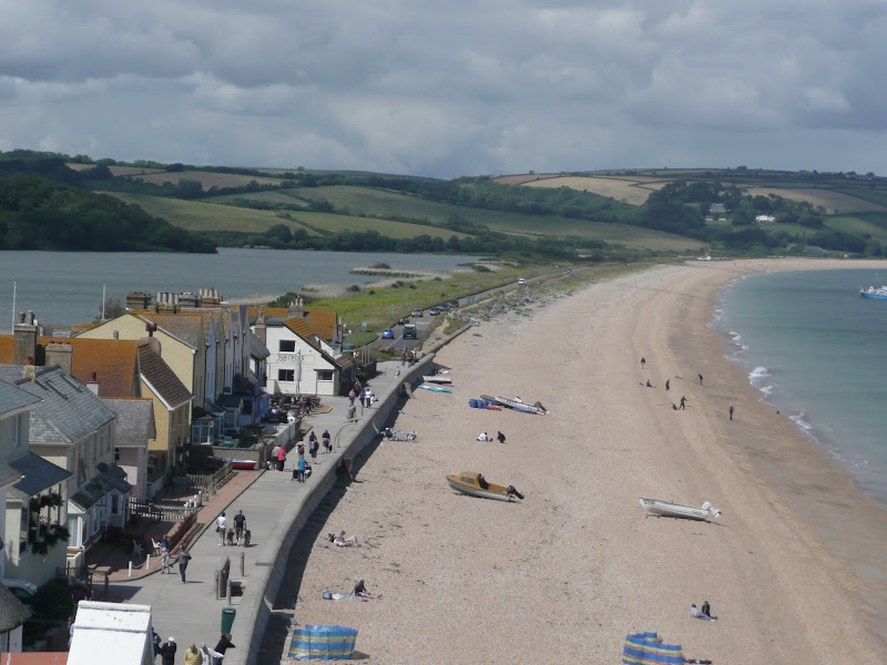
An exhilarating 4 mile walk along the defence banks of Suffolk's River Alde estuary beginning and ending at Slaughden Quay
Once known as the Vale of Slaughden, the area below Aldeburgh presents a big open landscape across the marsh with the wide estuary waters of the River Alde as it meanders alongside the coast. Once upon a time Slaughden was a bustling fishing village but in present day it is all under the waves and a narrow spit of shingle is all that divides the North Sea from the gentle waters of the river.
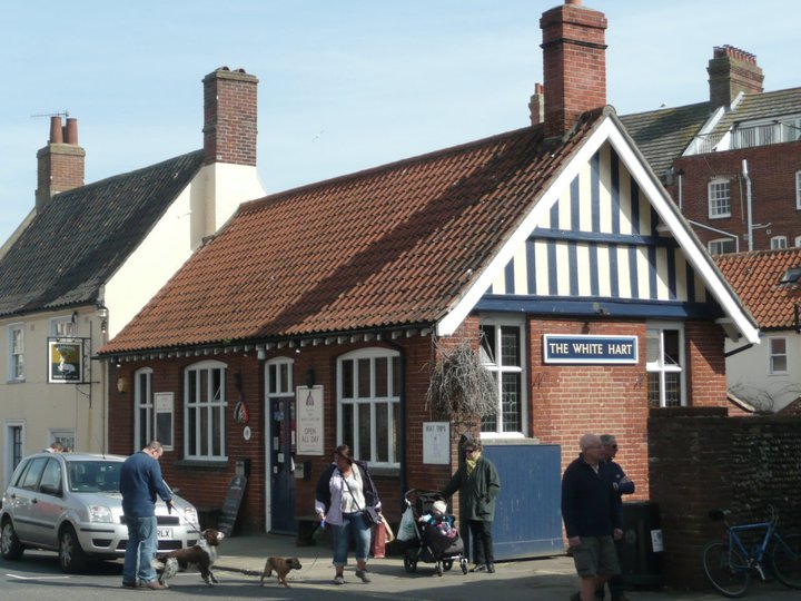
A 13 mile circular walk from Leiston to the White Hart Beer Festival in Aldeburgh
Easter 2011 was a really warm and sunny occasion and what better way to spend a Good Friday and Easter Monday than a casual walk through to Aldeburgh where The White Hart pub was holding its 9th Annual Beer Festival. Over 30 ales from across the country plus a selection of real cider, this really had to have something for everyone.
A circular walk from Sizewell to Aldeburgh along the Suffolk Coast Path
The Suffolk Coast Path does not go into Aldeburgh but it is a simple excursion to continue along the beach all the way down to the unique clover leafed Martello Tower at the vanished village of Slaughden using the old railway track to make a circular walk.
A 6 mile beach walk to witness the damage caused by the 2013 Storm Surge at Cromer and Sheringham
Both Cromer and Sheringham bore the brunt of the storm surge on the night of December 5th 2013. Although repair work is well under way there are still the signs of what damage the sea can cause. There have also been many cliff falls along this length of coastline with the cliff faces providing a fascinating view sculptured by the weather and tides and offering multi coloured strata.
A circular walk around the Area of Outstanding Natural Beauty at Sizewell
This walk has a diverse landscape that has something for everyone. Woodland, coast and beach, freshwater marsh and Sandlings Heath which is a delight to any visitor and worthy of its status as an Area of Outstanding Natural Beauty. The walk heads out of Leiston alongside the man-made Aldhurst Farm nature reserve, an area of wetland, heath and grassland created in 2015 as a sweetener for the local folk should the proposed Sizewell C Power Station get approval. It isn't presently accessible to the public other than the established footpath that runs along the valley and a new path running adjacent to Valley Road. The north side of the reserve was once known as Winters Heath, common land that was enclosed in the early 19th century. Therefore this is not so much as giving something to the community as returning the access rights to the people that such common land once afforded.
Views across the marsh to minsmere, an area that will be covered with spoil heaps from the construction of Sizewell C
Moving on up to the top of the hill on Lovers Lane where we take the track off to the right as the road bends around to the left. An interesting feature on the OS maps at this location is an area marked as Fiscal Policy. This is thought to be a so called Trap Street, a fictitious location that is used as a copyright marker for the cartographers work. This specific fictitious location has been added to OS maps since the 1920s and has varied its exact location over the decades, although keeping within the general area of the western side of Kenton Hills. It is certainly not a location known to locals and appears on no other maps of the area other than the Ordnance Survey. It is notable that there are many references to the area of Fiscal Policy made in modern documentation written by both Suffolk Council and EDF, the Power Station operators. This goes to show the lack of local knowledge these bureaucrats and business managers have which may account for their scant respect for the surrounding landscape.
The route then heads through a car park and into the woodland through the areas known as Kenton (marked as Tenton on 19th century OS maps) and Goose Hills. The naming of the area as Hills is not self evident from the tree covered landscape. It has to be said that there is a triangulation station in the depths of Goose Hill but this is only at an altitude of 9m with the surrounding landscape no less than 5m. I guess a mere 4m high piece of land surrounded by marsh may look like a hill but it certainly is not self evident within the dense forest. The names of Kenton Hill and Goose Hill date back from long before the forest was planted, when the area was Sandlings heathland. It wasn't until the 1960s, with the coming of Sizewell Nuclear Power Station, that the heath was planted with a managed forest. Going back further in history the area is thought to have been parkland attached with the 14th century Leiston Abbey, some documents describing it as a deer park.
There are many tracks through the woods including a section of the The Sandlings long distance trail as well as specific colour coded way-marked trails. This particular route takes the unmarked perimeter paths out to the extremities of Goose Hill where there are views onto the marshes to the south of Minsmere and a purpose built hide for those who want to spend some time discovering the wildlife of the marsh. Whatever route one takes, navigating to the eastern edge one will find two footbridges which provide access across to the coastal section of this walk.
Goose Hill and Kenton Hill Woodland
Sizewell beach offers both coastal heath and a shingle beach to walk along. The northern section at the point where the path emerges from the woods, was once a 19th century rifle range which I believe was also used during WWI as target practice for the troops. The beach and heath paths pass in the front of the two power stations at Sizewell and is a very popular for both tourists and locals walking through to Minsmere Sluice and beyond. For those wanting refreshments there is the Vulcan Arms pub at Sizewell as well as the Sizewell T cafe although this is closed over the winter months.
Return uses the medieval track through to Broom Covert. This was the original route between Leiston and Sizewell before the modern road was introduced in the 19th century. Broom Covert is an area of ancient Sandlings heath that is a delight to walk through and is another highlight of this walk, its contoured grassland hinting at hidden earthworks that may lie beneath. It is thought that this area was extensively used for troop training during WWII and there may be hidden structures dating from this period lying beneath the surface.
A permissive path leads across the meadow at Round Covert to Reckham Pits Wood which was originally part of Leiston Common, the woodland growing up in the early 20th century after it had been used for aggregate excavation. The mixed woodland is a much wilder landscape than that of Kenton Hills, with a cacophony of trees, foliage and fauna all competing for space, a blaze of colour and light in all seasons. Above the woodland is what is left of Leiston Common, correctly known as Leiston Dry Common to distinguish it from Leiston Wet Common which once occupied part of the marshes. The Common features in many local tales and stories of 18th century smugglers who would stash their booty in holes dug into the sandy soils of the common. There is a permissive path on the north side of the common that leads down to the marsh known as Sizewell Belts and across to Kenton Hill woods. The public footpath leads out onto Lovers Lane with a new footpath adjacent to Valley Road to take the walker back into Leiston.
Broom Covert, natural Sandlings heathland
It has to be stated that much of the landscape this route passes through may disappear in the next decade due to industrial usage despite its status as an Area of Outstanding Natural Beauty. The proposed Sizewell C power station will claim some of the woodland, specifically much of Goose Hill which will be replaced by an access road to the construction site and a railhead. The route of the proposed railway will run adjacent to Kenton Hills and may well devastate the fictitious area known as Fiscal Policy!. No doubt Goose Hill will be flattened with the introduction of the road, its trig point no longer applicable with the tallest structures becoming the 20-30m high spoil heaps which will dominate the landscape from the present site of Sizewell B through to Minsmere sluice and across to Eastbridge.
Public access to the woodland may become limited with no access through to the beach. The coastal access will be restricted during the construction of a loading jetty and sea defences, and the coast path may be blocked up for the duration of the build depending upon the design of the pier head that is chosen. The long distance routes of the Coast Path and the Sandlings Path will get diverted along Lovers lane and then taking the roads through to Eastbridge, a lengthy diversion along asphalt which is not conducive to committed walkers and hikers. There will no doubt be contention between road users and pedestrians, such confrontations already occur when walking the local roads so this will only get worse with the increased traffic. This re-routing is a big concern as many walkers make use of the coastal section from Sizewell through to Minsmere which makes the local area an attraction for outside visitors who may well be put off by such unpleasant walking diversions.
On the southern side of the route, Broom Covert was set to be requisitioned for the construction of Proposed East Anglia One/Two Windfarm Substations which were set to dominate the area, its buildings being some 18m in height. There was much opposition to this, the land being a prime example of Sandlings Heath and deserving of its Area of Outstanding Natural Beauty status. Fortunately it seems this threat has abated in preference to a site at Friston which itself is gaining significant opposition. The coastal land between Thorpeness and Sizewell is still threatened to be torn up and footpaths blocked up. Considering that this area is popular with both locals and visitors alike, it demonstrates the lack of local knowledge these corporations have of the area and just how much it attracts visitors. When, at a recent exhibition of the proposed development, the question about the blocking up of footpaths was put to ScottishPower Renewables, the rep seemed honestly aghast that we had walked two miles to get to the exhibition in Thorpeness. This demonstrates their lack of knowledge of the area. We walk. Two miles is around the corner. We do not want to be forced into cars. These footpaths are our access along the coast.
There are already two windfarm substations constructed at Sizewell. The big issue with all of this is each Power company appears to want their own substations whereas a more holistic and integrated policy would cause less development, less disruption and benefit all. Probably the best idea would be to have an off-shore ring main to connect all of these power sources rather than bringing the lines to a separate substations for every single wind farm that is built. However the power companies do not appear to be interested in such solutions. Cooperation appears to be a dirty word to these monolithic corporations.
To cap it all, there is an idea being put about to market this section of natural heath, marsh and sandling coastline as The Energy Coast. This is a gimmick to put a cosy name to what will be no more than industrialisation of the Suffolk Coastline. There are a lot of people out there, both local and from further afield who would prefer this to stay as a natural coast, a coast that harbours wildlife, where one can seek solace and peace, where one can sit or stand and admire the landscape, not a huge construction site under the marketed guise of The Energy Coast.
Finally, jumping the gun with the assumption that the construction of Sizewell C is a foregone conclusion, EDF have been given the permission to extend Sizewell B, destroying the 100 year old Coronation Wood in the proceess in order to accommodate a car park. This is currently being opposed by a local groups who have succeeded in forcing a judicial review in the High Court to challenge the planning decision.
Without a doubt this landscape will change drastically in the near future. Therefore if you want to enjoy this natural beauty, do so sooner rather than later or you will probably never get to see it due to the plethora of industrial constructions that are being proposed to completely devastate this area for the next 20 years and probably beyond. Gone the marsh. Gone the sandlings. Gone the peace. Gone the landscape. However, if you are into concrete landscapes, massive industrial constructions, busy roads, endless traffic, hoards of lorries then you will be in your element.
A walk encompassing the Westwood Marshes footpath into a circular route from Leiston
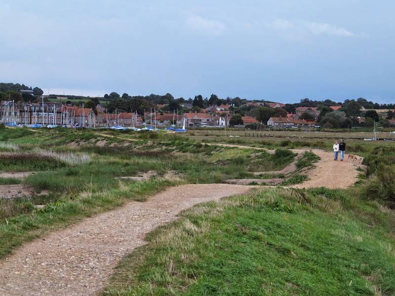
The Westwood Marshes footpath is little gem of a path that links the Newdelight Walks with the Suffolk Coast Path through the Westwood marshes. The route for this walk uses this path as the ultimate destination from Leiston but shorter alternatives to include this path are also detailed.
A 14 mile coastal walk between Gorleston and Kessingland crossing the border from Norfolk to Suffolk
This mighty fine walk takes the avid rambler to the most easterly point of the British Isles, Ness Point that is located in front of Lowestoft. The point is marked with a large circular ground compass with distances and direction to well known landmarks around the globe. The route uses cliff top paths, proms and beaches and makes for a great days walking.
A 12.5 mile walk along the South West Coast Path between Salcombe and Torcross
This walk begins with taking the ferry across the estuary from Salcombe to Portlemouth. The going at times is strenuous, navigating along the craggy cliff face through to Prawle Point, the most southerly point in Devon. Beyond there are some low lying pastures that is a real pleasure to wander through. The final stage negotiates the craggy cliff around Start Point before slowly descending the cliffs along Start Bay, passing the hamlets of Hallsands and Beesands and finally arriving at Torcross beach.
A 9 mile walk following the Cleveland Way between Saltburn and Staithes
This walk passes over the highest point on the east coast of England, a 670 foot high cliff at Boulby. The entire route bears the marks of numerous quarrying operations from over the centuries. The village of Skinningrove is roughly half way, and it is this place that holds a legend of a merman being captured and held in one of its cottages.
The future of the 2.5 mile walk along the sea defences between Blakeney and Cley
The December 2013 Storm Surge caused major damage to the sea defences along the Norfolk Coast Path that encompasses the Blakeney Freshes. Work is currently being carried out to repair the breaches, however the long term future of both the Freshes and the coast path at this point is uncertain.
A 10 mile walk following the southern side of the parish boundary of Leiston in Suffolk
This is the second article devoted to the walk following the route of a 17th century perambulation around the southern side of the Leiston Parish boundary. This article is concentrates on two landmarks from the past, namely Sizewell and Thorpe Beacons, which are thought to have been part of the Armada warning system.
An 11 mile walk from Loddon to Reedham along the Wherrymans Way, returning along the same route.
There is no public transport linking Loddon and Reedham, and few other footpaths in the area which is predominately marshland around the river Yare. Therefore this walk requires one to return along the same route. This should not detract one from walking this as it is a very pleasant ramble along the Wherrymans Way with pubs at Reedham making a veritable half way refreshment stop.
A 6 mile walk along the original route of the Norfolk Coast Path between Cromer and Sheringham
Up until December 2014 the official route of the Norfolk Coast Path from its start at Cromer Pier through to Sheringham navigated inland along the hills of the Cromer Ridge, the highest ground in Norfolk. This original route can still be walked and contrasts with the cliff-top route of the realigned path which is now part of the England Coast Path. With shady lanes and tracks through the woodland, spectacular views from the summit of Beacon Hill and the challenging ascent to the iconic Beeston Bump, this walk is a worthwhile excursion from the coastal route.
Latest walk summaries are basic information sheets for walks that have yet to be fully documented. These provide links to maps, public transport and walks stats, although detailed notes and features are not included.