Route details, maps, pubs, features, local history and folklore for a wide variety of walks focusing primarily on Norfolk and Suffolk

Walks
Showing posts sorted by relevance for query Dereham. Sort by date Show all posts

Saturday 29 December 2018

Nar Valley Way - Narborough to Dereham

Newton Mill

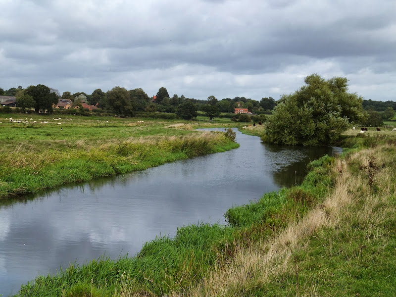
A 22 mile walk along the Nar Valley Way from Narborough to Dereham

This route is full of historic features including ruins of priories and castles as well as magnificent halls and watermills. The walk provides a varied landscape with woodland trails, riverside paths and saunters across open fields of this pleasant Norfolk countryside. Although a lengthy section of the Nar Valley Way there is plenty of time to accomplish the feat with late buses linking the two ends.

Friday 6 December 2019

The Wensum Way - Dereham to Lenwade

River Wensum near Bylaugh

A 13 mile walk through the Norfolk countryside following the Wensum Way

Opened in 2012, the Wensum Way was the connecting link between the Nar Valley Way and The Marriott's Way to enable a Cross Norfolk Trail from Kings Lynn to Great Yarmouth. The name of the trail is taken from the River Wensum which it follows from Swanton Morley through to Lenwade. This is a picturesque ramble through the Norfolk countryside.

Thursday 22 November 2018

Wells, Wareham, Wighton and Railways

River Stiffkey

A 9 miles circular walk that follows the Walsingham light railway from Wells-next-the-sea to Wighton with a return along tracks that make up National Cycle Route 1

This is a short circular walk taking in the villages of Warham and Wighton just inland from Wells and following the route of the Wells and Walsingham light railway. There is plenty to see along the route including paying a visit to the old Wells-next-the-sea Railway Station, which is now a fascinating second hand book shop and pottery studio. There is an iron age fort known as Warham Camp in the fields between Warham and Wighton and return is via the curiously named Gallow Hill on the Holkham estate. There are two pubs on route, the Carpenters Arms at Wighton and the Three Horseshoes at Warham, a pub with real old world character full of curiosities which is worth the walk alone.

Thursday 24 February 2022

The Peddars Way - Watton to Castle Acre

Watton to Castle Acre

A long and straight trail across lanes and tracks from Watton to Castle Acre.

Once at Little Cressingham the Peddars Way draws a long straight line through across the landscape. Gentle undulations provide little in the way of changing scenery and The Blue Lion at North Pickenham provides a very welcome half way point to rejuvenate ones energies and rest ones weary legs and feet from the hard tracks and metalled lanes. Castle Acre is a novel little village with its castle and priory ruins, both of which are well worth exploring.

Tuesday 17 December 2019

A Walk along the Bure Valley Path

A 9 mile walk along Norfolk's Bure Valley Path between Aylsham and Wroxham

The Bure Valley Path follows the former Great Eastern Railway trackbed alongside the Bure Valley Narrow Gauge Railway. There are outstanding views of the river Bure and stops on route at Brampton, Buxton and Coltishall. Being a former trackbed gives a well drained path so the route is suitable for all weathers.

Friday 6 December 2019

Nar Valley Way - Kings Lynn to Narborough

Brick remains from the bridge which carried the former Kings Lynn to Dereham railway

A 15 mile walk following the River Nar from its outlet to the River Ouse up to Narborough

The walk starts along the quayside at Kings Lynn with all its fascinating historic buildings. The path soon heads out into open countryside following the river across this open landscape. Big skies. Views for miles and little in the way of civilisation until Narborough is reached.

Tuesday 27 November 2018

The Weavers Way

Weavers Way Marker

An overview of the The Weavers Way, a 60 mile long distance footpath through Norfolk linking Cromer and Great Yarmouth.

The Weavers Way takes its name from the cottage weaving industry that established itself during Middle Ages around the North Walsham area. The path is characterised by the various sections that it passes through on route, firstly historic halls, then old railways followed by river walks before the final section across the lowland Norfolk landscape with its characteristic big skies.

Saturday 12 January 2019

Down the Blyth Valley in Pursuit of Black Shuck

River Blyth near Halesworth

An 18 mile walk down the Blyth Valley in Suffolk from Halesworth to Blythburgh, then across the heaths and commons to Leiston.

It was the legendary hell hound that supposedly came this way in 1577 and terrified parishioners of Blythbrugh church after doing a similar job at Bungay. This walk is in two sections, the first section follows the River Blyth along the Waveney Way to Blythburgh with the option to continue on to Southwold. The Waveney Way is a Ramblers Association walk and does not have waymarkers along the route. An optional second section cuts across to Westleton and onto Leiston. Both Southwold and Leiston have public transport links to Halesworth making the walk achievable as a linear route without the requirement of assistance of a taxi.

Wednesday 27 November 2019

A Hike along the Marriotts Way

Sculpture that marks the start of the Marriotts Way at Norwich

The Marriott's Way links Aylsham and Norwich following the former trackbed of the Midland and Great Northern Railway.

The Marriott's Way is a footpath, bridleway and cycle route, which follows the routes of two disused railway lines, and runs between the historic market town of Aylsham and the medieval city of Norwich. Along with the mileage markers which are created from old rails complete with a metal rubbing plaque, there are numerous concrete sculptures, village markers, interactive sound boxes and benches which all provide added interest and information along the route.

Walk Summaries

Latest walk summaries are basic information sheets for walks that have yet to be fully documented. These provide links to maps, public transport and walks stats, although detailed notes and features are not included.

Latest Walk Summaries

Featured Walk

In Search of Sizewell Chapel

A 10 mile walk following the southern side of the parish boundary of Leiston in Suffolk This walk follows the route of a 17th century peramb...

What is GPX

All you need to know about GPX, electronic mapping and how to use modern apps and mobile devices as navigation devices

Popular Walks

Maps