SWCP Braunton to Croyde
|
Sunday 6 February 2022
|
No comments |
![]()

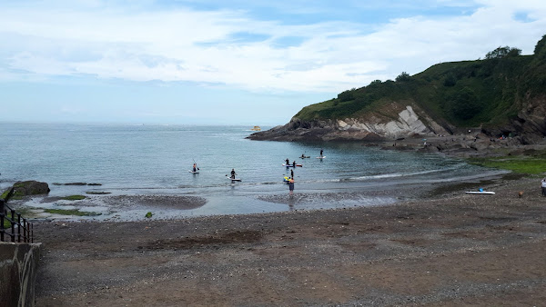
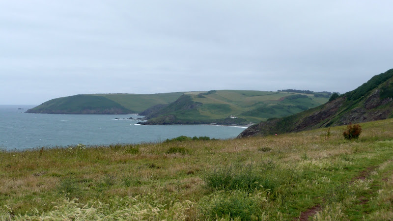
Braunton to Croyde
Walk along the South West Coast Path between Braunton and Croyde on the North Devon Coast
|
Sunday 6 February 2022
|
No comments |
![]()
Walk along the South West Coast Path between Braunton and Croyde on the North Devon Coast
|
|
No comments |
![]()

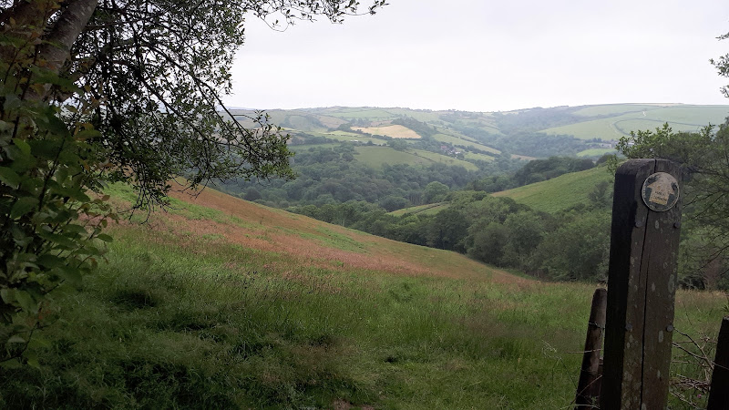
Short walk round the headland known as Baggy Point
|
|
No comments |
![]()

Circular route from Ilfracombe along the old railway track to Lee Bay, returning along the South West Coast Path
|
Saturday 5 February 2022
|
No comments |
![]()

An amazing walk full of spectacular views along this rugged part of the North Devon coast
|
|
No comments |
![]()
A short but strenuous walk across Hillsborough Hill that separates Ilfracombe and Hele Bay.
|
Wednesday 15 December 2021
|
No comments |
![]()
A 7 mile walk around coastal North Devon from Hele Bay to Berrynarbor
This walk takes inland footpaths and tracks to navigate from the village of Hele Bay through to Berrynarbor, which, with its whitewashed stone walls takes on the guise of a Mediterranean village. The village plays host to numerous flower pot men in comical poses which makes an intriguing spectacle as one wanders through the streets. Return is along the South West Coast Path
|
Thursday 19 December 2019
|
No comments |
![]()
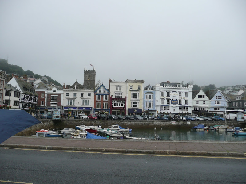
A 9 mile walk along the South West Coast Path between Dartmouth and Torcross.
This section of the walk starts at the deep water port of Dartmouth which is famed for where the second and third crusades departed in the 12th century. Across the River Dart is Kingswear, and down the estuary is Dartmouth Castle, built in the 15th Century. Passing the castle, the path heads round the coast and up to the village of Stoke Fleming, then meanders across the hills and lanes either side of the main Dartmouth road until it meets Strete. Here it descends down to Slapton Sands, which despite its name, is a shingle beach on one side and Slapton Ley, a natural freshwater lagoon, on the other. A simple walk with a few hills to negotiate and a bus service that links the two ends of the walk.
|
Wednesday 18 December 2019
|
1 comment |
![]()
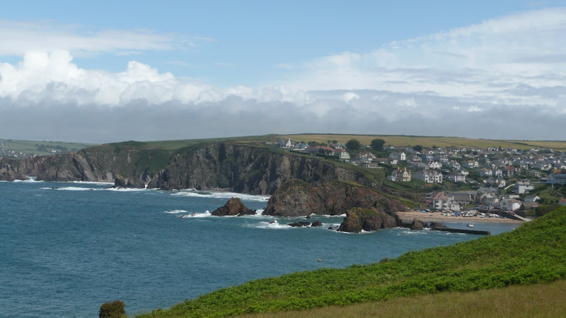
A 17 mile walk along the South West Coast Path between Churchstow and Salcombe.
This walk heads out from Churchstow through country lanes down to the South West Coast Path at Bantham on the Avon estuary. The Coast Path starts with easy walking along the low cliffs past Thurlestone and includes an 80 yard footbridge across South Milton Ley before it arrives at Hope Cove, a picturesque little fishing village. The section from Bolt Tail to Bolt Head is a little more strenuous with the path tracking up and down the cliffs and around a few craggy sections with steps built out of the stone. At Bolt Head the coast bears round to the north passing Sharp Tor which is cut out of the cliff-face, before it heads down into the pretty village of Salcombe.
|
Tuesday 17 December 2019
|
No comments |
![]()

An 16 mile walk along the South West Coast Path between Bucks Cross and Hartland
An easy start to a walk through the tree covered cliff-tops makes a pleasant ramble through to Clovelly. There follows a couple of challenging valleys to cross and then broad open meadows for more easy walking through to Hartland Point. At this stage the coast turns South to reveal a coastline that can only be described as truly spectacular.
|
|
No comments |
![]()

An 8 mile walk along the South West Coast Path between Bucks Cross to Westward Ho!
A moderate walk along the cliffs to Westward Ho!, the town renowned for being the only place in Britain to have an exclamation mark in its name. This walk presents a good introduction to the South West Coast Path being under 10 miles and with few difficult or strenuous ascents and descents. There are amazing panoramas of the coastline throughout with views to Hartland in the west and Westward Ho! and north Devon to the East and North.
|
|
1 comment |
![]()

A 12 mile walk along the South West Coast Path between Brixham and Paignton.
There are a few moderately strenuous sections to this walk but nothing too arduous. The walk starts by heading out to Berry Head, the site of a an iron age fort, although most of this has been destroyed by late 18th century fortification for the Napoleonic Wars. The path then descends down into Brixham town where there are refreshment houses and shops set around the harbour. Brixham is much more of a heritage fishing town rather than its commercialized holiday resort neighbours of Paignton and Torquay. Out of Brixham, the path makes its way across the cliffs descending to Broad Sands and Goodrington Sands before reaching Paignton.
|
|
No comments |
![]()
A 10 mile walk along the South West Coast Path between Brixham and Kingswear.
This section is one of the most strenuous walks along the Exmouth to Plymouth section of the Coast Path but offers some spectacular views. There are craggy cliff-face paths as well as gentle wooded zig-zags before it finally meets the lanes that emerge by the railway station at Kingswear. A frequent bus service operates between Brixham and Kingswear to allow the walker to return to the start point.
|
Tuesday 5 February 2019
|
No comments |
![]()
A challenging but rewarding 17 miles hike along the South West Coast Path between Salcombe Regis and Lyme Regis
This is an extensive hike that can be split in two at Seaton. The first half has a number of steep descents and climbs as the path negotiates the numerous combes where streams exude to the sea. The second half is a point of no return that navigates through the undercliff to Lyme Regis. There is no way out and this is an extensive hike through the densely vegetated landscape.
17 miles seems like a perfectly decent distance for a day walk. However with the SWCP one has to take into account the landscape and in this specific walk it is a challenge to complete the full distance and one should be an experienced walker to take this on in one go. If there is any uncertainty then it should be broken down into two smaller walks with Seaton as the convenient point to split the walk.
Having stated this the scenery is awesome from start to finish. With base camp at Salcombe Regis, there is a convenient path that takes one down to the coast path on the eastern side of the deep valley that leads to Salcombe Mouth. Despite being half way up the valley side there is still steep climb out to get over the 156m Dunscombe Cliffs. The path then drops right down to beach level at Weston Mouth before climbing back to 162m as it negotiates Weston Cliff. There's more effort required to get around Branscombe, eventually getting back down to beach level at Branscombe Mouth. Once one is up then one has to go down and once one is down one has to go up.
The coast then turns and one drops down into the village Beer. Yes, Beer. What a great name for a village. Whenever anyone enters Beer then it only seems appropriate that one should toast its name with its namesake beverage. The The Anchor Inn provides an ideal opportunity for such a celebration, a well placed hotel that has a garden on the opposite side of the road through the village, overlooking the seafront. A great position, great ale and, as expected, a very popular place for folk similarly toasting the village name. Its all about location and a beer in Beer is the best location in my beerbook.
There a climb over Beer Hill and the path then descends down into Seaton. Now this small town brings back memories when, during the 1980s, I had a week of camping just outside the town. There was one specific pub that was frequented during that week and they brewed their own beer. If I remember correctly each brew had a railway themed name. Starting at the tame Rail Ale it went through to the powerful dark Sleeper. I believe this was the Beer Engine brewery which appears to have relocated to Exeter. On one specific night at this house of repute, the landlord had gone out for the evening, the Chef was drunk and the barman was liberally plying all and sundry with copious amounts of ale, much of it without charge. That evening the Sleeper Ale lived up to its name.
Unfortunately I could not remember the location or the name of this pub and with many more miles to go then a swift drink at the Hook and Parrot was called for before headign otu on the second half of the days expedition. This seafront bar was clearly aimed at the tourist trade although they did have some ale on offer.
It must be stressed that the walk from Seaton to Lyme Regis, although only some 7 miles is nonetheless a challenging hike with no way out other than returning the way one came. This route navigates through the Axmouth to Lyme Regis Undercliffs Nature Reserve, an area of dropped cliff forming a broad shelf part way down the main cliff. The trail is rough, steps are uneven, paths can be muddy and slippery, as experienced on this expedition despite there being little rainfall in the week leading up to the walk. The whole area is covered in tall trees and dense vegetation that some describe as a jungle. There's not much in challenging climbs but the sheer effort to get through this is demonstrated by the warning signs as one enters the area. In addition one should be aware that Lyme Disease carrying ticks can be encountered in the area and one should take suitable precautions against them.
Having said all this, the trek through the undercliff is an amazing experience and although there are only glimpses of the sea, there is so much more to see and discover. The path undulates around the contours, up and over the various hillocks and around the crags and boulders. Ruined buildings are at the heart of the reserve, the remains of a landslip. Flora, fauna and wildlife abound and one could easily take a full day slowly meandering through this seclude piece of nature.
It has to be admitted that emerging from the undercliff and down into the harbour area of Lyme Regis was a rewarding and satisfying feeling that the distance had been completed. The legs complained. The feet hummed. This endurance was duely rewarded with a pint of Palmers beer to soothe the thirst and revive the muscles as feet were put up on the benches outside the Cobb Arms. It is worth a rest at this busy pub before moving along the beach front to town centre where buses stop for the return journey. And whilst one waits there is always the chance for another pint of Palmers at The Rockpoint Inn although in November 2018 the pub was taken over by the St Austels Brewery so maybe the beers have now changed.
|
Sunday 3 February 2019
|
1 comment |
![]()
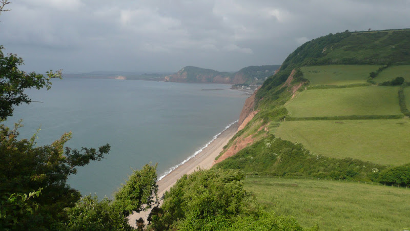
A pleasant and not too challenging 16 miles ramble along the South West Coast Path between Exmouth and Salcombe Regis
This route is a great introduction to the South West Coast path with all the amazing panoramas, cliff top views and a few challenging ascents and descents. But nothing too demanding. This walk uses the Salcombe Regis campsite as its base location but the walk can simply be terminated at Sidmouth.
This was the first stage of a 10 day walking expedition along the Jurassic Coast section of the South West Coast Footpath between Exmouth and Poole. It is a great part of this long distance trail and if this is ones first visit then, like us, the lure of the fantastic scenery and amazing paths seduced us back in the following years to continue to walk of the whole SWCP trail.
This particular walk was undertaken on the day of arrival which resulted in limited time to undertake it due to having to arrive on site and pitch the tent. However, performing this during the mid summer provides ample evening light to complete the distance. The arrival at the Salcombe Regis campsite was a revelation in itself. Located at the head of the valley leading down to Salcombe Mouth and with views of the deep blue sea beyond and the sloping hillsides full of small fields of pasture intermingled with woodland. A fantastic view that makes one just want to submerge oneself into the landscape. And it was peaceful. Very quiet with few tourists on the campsite and just a distant sounds of donkeys at the nearby donkey sanctuary. I am sure one could scream here and nobody would hear you, you voice would just melt into this idyllic landscape.
Luck was on our side for this walk. There was a bus operated by Stagecoach which linked Sidford, some 15 minutes walk from the site, with Exmouth and the start of the walk. Unfortunately this 157 service no longer appears to serve Sidford and one must continue down into Sidmouth to catch the same bus.
The South West Coast Path is a naturally start end point at Exmouth with the river Exe forming a natural boundary where a ferry connects to the next stage at Starcross. The trail then continues from the ferry and follows the estuary along the Exmouth seafront. It is easy to find as one just has to head to the beach and start walking, following the esplanade all the way along the edge of town where there are a flight of zig-zagging steps to get to the top of the cliffs for the real walk onward.
This section of coastline is a popular tourist destination and there are numerous holiday camps and caravan parks that dot the cliff tops. Despite this, the area is dominated by open fields and rolling countryside with fantastic coastal views as the path heads up to West Down Beacon at 129m. There is then a steady descent down to the town of Budleigh Salterton and a chance to find refreshment. Cliff Road leads from the beach to the main thoroughfare through town and at the junction is the Feathers Hotel. This was a pure chance discovery as are most of the pubs and inns frequented on this site. This was a good choice as there were four local ales on offer and a welcoming host and a drink to toast the start of what was looking like a grand expedition.
Beyond Budleigh Salterton the path has to head inland to negotiate a route around the Otter Estuary Nature Reserve. This is the River Otter and not an otter nature reserve. I think that if you are an otter enthusiast then you would be sorely disappointed with the distinct lack of the semi-aquatic carnivorous mammals. The path follows a 1.5 mile excursion around the marsh and wetland of the estuary before the trails heads back along the cliffs once again.
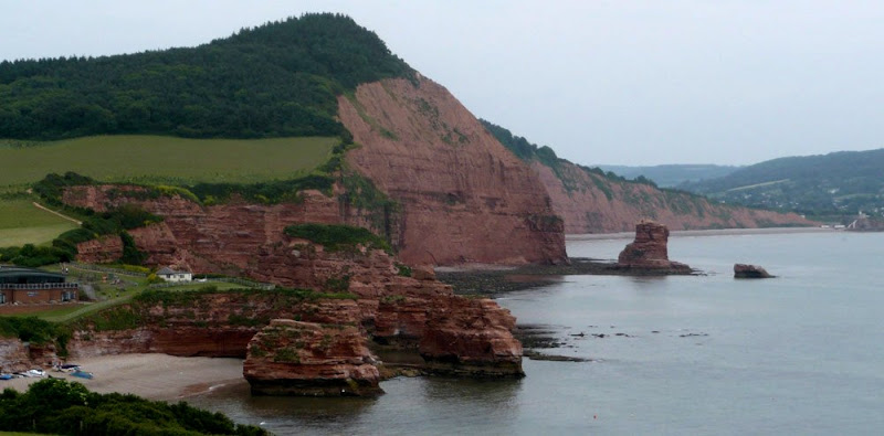
There is an amble across to Ladram Bay where one encounters the impressive sandstone sea-stacks, weathered and eroded. The views of these island stacks cant fail to amaze and it is well worth taking some time out to gaze and admire and capture a little essence in a photo The trail descends down to the beach road before making a slow steady ascent of the imposing wood covered hill beyond. The going gets more challenging before the summit is reached. This is High Peak and at 157m is the highest point along this short section of the trail. This climb takes a little effort but is well worth it for the view. The eastern side is a slow descent that takes the coast path into Sidmouth.
On this occasion, it was early evening by the time we reached Sidmouth, sometime around 7pm. The town was busy, not full of tourists but a lot of locals since the FA World Cup was in progress and England's National Team were taking on the lowly Algeria in the evening game. After finding a chip shop to feast on what must be one of the nations favourite meals, it only seemed right that we should endorse our patriotic rite and frequent a hostelry to catch the impending game. Expectations were high that England would show their metal and commanding experience and professionalism and demolish this lowly upstart to the sport. A seafront bar was located that was openly advertising the game. The Marine appeared to be one of those tourist enticing bars that left expectations of lots of fizzy beer and loud-mouthed youth but on entering we was pleasantly surprised. Two cask ales were being served on tap, and a few seats available amid the mild mannered audience. It has to be said that the bar was more like an electrical showroom with the number of TV screens that decorated the walls and I was unsure whether this was specific to this event or whether it was the norm. Unfortunately the game was a complete let down. The 0-0 scoreline said it all with the England layers ambling along like they were on a Sunday walk in the park. Their passing was abysmal and their play unenthusiastic and slow-footed. Having said that the Algerian team must have been delighted with their performance in keeping England contained.
Disappointed with the result we left the pub at 9.30 and photographed a public convenience sign. It said it all. By this time the light had stated to fade and it was going to be a challenge in getting up to the campsite as the route negotiated various pieces of woodland. The first hill of trees to the east of the town heads up to the cliff tops and this soon demonstrated the lack of light. Torches were of assistance but nothing is anywhere near as good as daylight. Nonetheless taking ones time arrival at base camp was completed and the end came to what had been a fantastic day.
|
Thursday 10 January 2019
|
No comments |
![]()

An 19 mile walk along the South West Coast Path between Hartland to Bude
The section from Hartland to Bude is the most challenging part of the whole South West Coast Path. There are ten deep valleys to cross which seem unrelenting but the reward is some of the most spectacular scenery of the whole trail. This is definitely something for the more experienced hiker to undertake.
|
Thursday 27 December 2018
|
3 comments |
![]()

A walk along the South West Coast Path between Plymouth and the Yealm estuary with an extension along the Erme Plym Trail to get around the River Yealm estuary
Plymouth is not a place to find a country walk, in fact the South West coast Path leads you around some of the more industrial areas of the docks and along the busy road across Laira Bridge. From this point there is a more pleasant alternative route using the West Devon Path which traces the trackbed of a former railway to Hooe Lake. An easy walk around Clovelly Bay and Mount Batten Point finally brings the path onto the cliffs along the coast. The going through to Wembury is not too strenuous and it is worth taking time out at Heybrooke Bay to search out the Eddystone Inn from where you can see the lighthouse of the same name on the horizon. From Wembury the Erme Plym Trail leads back to the main road in order to get around the Avon Estuary.
|
Thursday 20 December 2018
|
No comments |
![]()
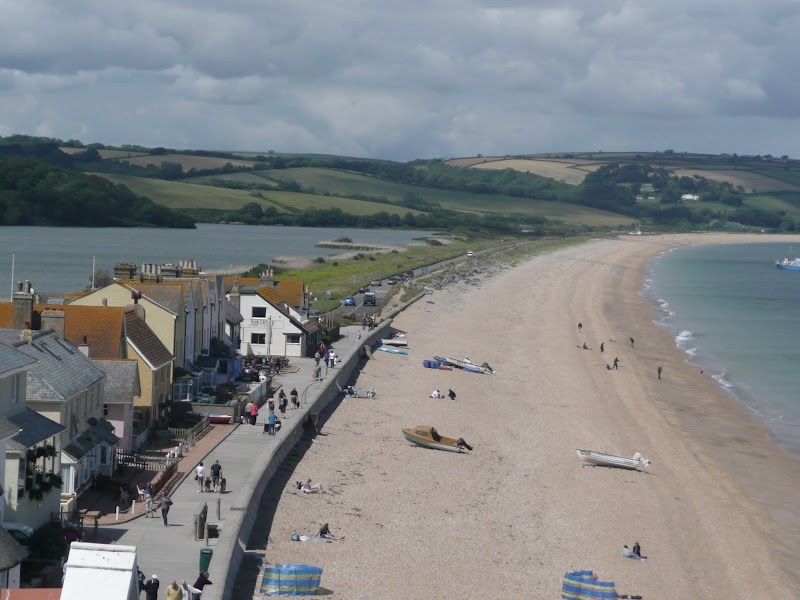
A 12.5 mile walk along the South West Coast Path between Salcombe and Torcross
This walk begins with taking the ferry across the estuary from Salcombe to Portlemouth. The going at times is strenuous, navigating along the craggy cliff face through to Prawle Point, the most southerly point in Devon. Beyond there are some low lying pastures that is a real pleasure to wander through. The final stage negotiates the craggy cliff around Start Point before slowly descending the cliffs along Start Bay, passing the hamlets of Hallsands and Beesands and finally arriving at Torcross beach.
|
Wednesday 12 December 2018
|
1 comment |
![]()
A lengthy section along the South West Coast Path taking in the the English Riviera between Starcross and Paignton
From the Exe estuary where the ferry links Exmouth and Starcross, the South West Coast Path heads southwards through the English Riviera Towns of Dawlish, Teignmouth, Torquay and Paignton. This section is a mixture of level walking through towns interspersed with hill walking through Maidencombe, Watcombe and Babbacombe and out to Hope's Nose. There are excellent transport links throughout including the iconic railway that runs along the sea wall from Teignmouth up to Starcross and is as inspiring as the walk itself.
|
Tuesday 20 November 2018
|
No comments |
![]()
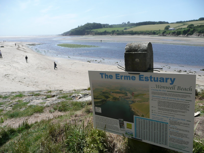
A 19.5 mile walk along the South West Coast Path between the Yealm and Estuaries, using additional footpaths to access transport to link each end of the walk.
There are ferries across both the Avon and the Yealm estuaries but this route takes a trail that enables navigation around them using footpaths and lanes. Even so, there is still the Erme estuary to negotiate midway along the coast. There is no ferry here but it can be waded across one hour either side of low tide. This is quite an experience but requires planning with reference to the tide times published for Devonport. There are few other features apart from the stunning scenery along this section of the coast walk until it gets to Bigbury on Sea where Burgh Island sits just off the coast and hosts the renowned Pilchard Inn. The island can be reached on foot at low tide and at other times the inn makes use of a sea tractor to drive visitors across.
|
Tuesday 17 July 2018
|
No comments |
![]()
Circular walk linking the County Gate car park and Lynmouth
There is no public transport between Porlock and Lynmouth, therefore a days linear walk is not possible if one requires to return to the start. This walk uses a mid-point of the County Gate car park, located on Exmoor, to provide a circular route using the SWCP and Coleridge Way. The SWCP section is not too strenuous and provides some amazing coastal views whilst the Coleridge Way makes a very pleasant ramble alongside the East Lyn River to return to the County Gate
A 10 mile walk following the southern side of the parish boundary of Leiston in Suffolk This walk follows the route of a 17th century peramb...


