Eye to Hoxne Circular Walk
|
Tuesday 20 March 2018
|
No comments |
![]()
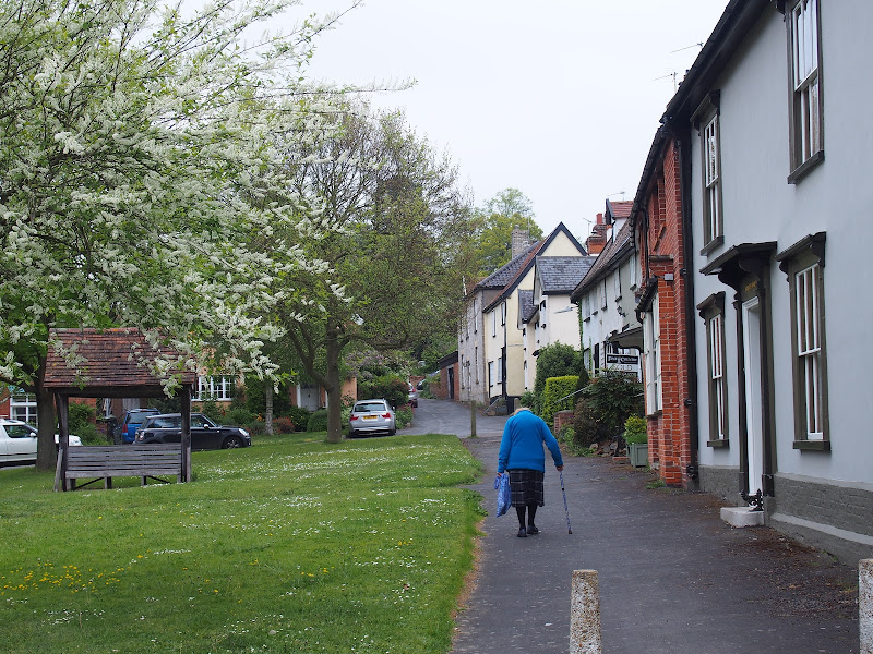
A 10 mile walk around the Suffolk villages of Eye and Hoxne
Hoxne is said to be where St Edmund was Martyred by the Viking invaders in the 9th century. The village is full of reminders of the gruesome event including the cross which marks the place of the oak tree his assailants tied him to, beat him, fired arrows at and eventually beheaded and the bridge he reputedly hid trying to escape his captors.
Eye to Hoxne Circular Walk - Essential Information
Walk Statistics:
- Start location: Eye
- Distance: miles ( km)
- Total Gain: ft ( metre)
- Total Descent: ft ( metre)
- Min Height: ft ( metre)
- Max Height: ft ( metre)
- Walk Time:
- Walk type: Circular
- Walk Grade: Easy
- Terrain: Footpaths, tracks with some road walking
Maps:
The following maps and services can assist in navigating this route. There are links to printed maps and links to downloadable GPX route data for importing into navigational software and apps.
- Ordnance Survey Explorer Map
- OS Explorer 230 - Diss & Harleston
- GPX Route File
Route Verification Details
- Date of Walk: 2017-05-06
- Walk Time: 10:00 to 15:30
- Walkers: Griffmonster, Kat
- Weather Conditions: Fine spring day
Walk Notes
Suffolk is renowned for its curious place names, Hoxne being just one of them. It is amusing to hear visitors attempting to pronounce this name with offerings such as Hox-nee and Honx-nuuuuhhh, almost as in duhh. The actual pronunciation is Hox-en, rhyming with oxen and there are two ideas of where this was derived from. It may have been a descriptive name from a hock shaped spur of land
although others contest that it was taken from the name of a Saxon tribal leader, literally meaning the settlement of the Hoxen
.
This ancient parish, listed in the Domesday book as Hoxana
, covers several villages including the hamlet of Hoxne itself along with Cross Street and Heckfield Green. This area is full of Suffolk charm with its flint church standing on parade at the top of the hill above the village, the olde worlde pub and a not-so-babbling brook which makes for a stereotypical Suffolk village.
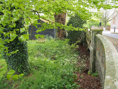
The distinguishing feature that draws most visitors to the area is its association with the martyrdom of King Edmund in the year AD870. This piece of history is ingrained into the area and one should not miss paying a visit to Goldbrook bridge (see picture below), where he reputedly hid from the Viking invaders, and the cross that stands in the centre of a field on the edge of the village. This is said to mark the spot of where a huge oak tree once stood on whose trunk Edmund was bound and whipped and beaten, then fired at with arrows until he resembled a hedgehog before finally being beheaded. The Vikings were not a friendly bunch by any means. In fact I would even go so far as to say they were quite an unsavoury bunch. The tree finally fell in 1848 and an arrowhead was discovered that had penetrated into the wood of the trunk, and they say that it was one that managed to miss Edmund.
There is also the site of the old Priory which is said to be the location those old Vikings threw Edmund's head. I told you they weren't nice characters, they come here, kill the locals King and then toss his head away regardless. Do not fret though, for his followers finally found it. They called for Edmund and miraculously the head answered here, here, here
leading them to the thicket where a wolf faithfully guarded it. Good old English folklore is this. With so many Vikings around his followers gave him a plain burial but then placed a humble chapel over the top of it. Given that the Vikings raped and pillaged and generally raised all religious edifices to the ground, a chapel does not appear to be the best of constructions to erect. Maybe they camouflaged it as it survived the Viking years after which Edmund's body was transported to Bury for a much grander burial. Some say this original chapel stood on the ground above the river crossing on Nuttery Vale Lane. There certainly appears to be artefacts of a chapel in the soil of this field.

With all this history then why shouldn't anyone want to pay homage to this village and to Edmund who was eventually canonised and became the patron Saint of England until St George took over the role. It was probably a bit tiring being a Patron Saint for several centuries! There have been attempts to restore his patronage in recent years with a petition handed to the Government in 2006 which was rejected without debate.
I have to admit there is a lot of controversy as to whether Hoxne was the specific location of St Edmund's martyrdom, but the fact is the association with the village has been around for at least 1000 years so it certainly has a long heritage with the historic event. Other places that may claim the title do not have the various sites to visit. There is only one Edmund's Cross and one Goldbrook bridge. A more thorough investigation can be read in the main article for this walk which I do advise you to read to get a full picture of the story of Edmund.
The walk to Hoxne is a leisurely stroll across the Suffolk countryside following part of the Mid Suffolk Footpath, a 20 mile trail that links Stowmarket to the Angles Way on the Waveney Valley, just past Hoxne. From there Diss (6 miles) is within easy reach. For this walk we present a circular route starting and ending in the village of Eye which is just south of Hoxne. There is plenty to see, visit and admire along the route in addition to historic sites of Edmund. In fact there is too much to document here so only a brief mention shall pertain until another expedition will seek to provide more information.
On the outward walk there are highlights of the old mansion house known as Brome Hall, home of the noble Cornwallis family for many centuries. The building dates from 1590 and its construction is attributed to Sir Thomas Cronwallis. The track that leads past this area is truly delightful with overhanging trees and a very neat and tidy grass verges. A brief wander along a country lane presents picture postcard cottages, thatched dwellings lost in time.
The River Dove links Eye and Hoxne and the path traverses the valley to cross it. This watercourse twists and turns its way along the valley from its source at Bacton through to the River Waveney. The river hides amid the tree borders and one cannot see it until the water is crossed by way of a simple footbridge that is gated at either end.
Once in Hoxne one has to stroll through the village thoroughfare, up the hill to the church. There are more quaint buildings, a green with a roofed seat and a wall composed of bottles and mortar. The church of St Peter and St Paul was originally dedicated to St Ethelbert before the Bishop of Norwich rededicated it to St Edmund. The present building dates from the 12th century with the 100 ft tower being added in 1450 by the second Duke of Suffolk, John de la Pole.
The return journey is via road and country lanes. One could just return the way one came but it is always good to make a circular route and although the stretch from Nuttery Vale Lane to the main road has few distinctive features, it is nonetheless on high ground with a broad panorama across the Suffolk landscape. Few cars pass along here, the lane used more by cyclists - this was certainly the case on this visit.
The highlights do not end here and on entering Eye there is the magnificent church, also dedicated to St Peter and St Paul plus the ruins of Eye Castle, an 11th century construction that was largely destroyed in 1265. In 1844 Sir Edward Kerrison built a stone house on the motte which became known locally as Kerrison's Folly. One can climb up to the folly by a flight of steps and have some magnificent views over the area. There is not enough space to dedicate to the church or the castle here so this will have to wait for another walk and another write up

Directions
Typical Suffolk countryside walk around this historic area
There is a car park in Eye, off of Cross Street that is signposted from the main route through the village. From here turn left onto Cross Street and head out of the village northwards. Just before the end of the buildings, on the right is a small close called Century Road. Walk along this for a few yards and then take the track on the left. Where this turns to the right along a field boundary take the path across the boundary to double back on oneself. This is the Mid Suffolk Footpath which will lead through to Hoxne.
At the junction with the track turn right and follow the track avoiding all turn other routes that lead off from it. Continue straight ahead at Brome Hall on the right, then follow the track around to the left to emerge out onto a country road. Turn right and follow the road for just under half a mile to where a footpath leads off to the right. This follows the boundary of some woodland and leads out onto a asphalt track. Turn right and follow this until it turns sharply around to the right. Continue straight ahead on the footpath which leads down to the river bridge. The path continue out of the valley and onto the road. Turn left and follow the road into Hoxne village. The Swan Inn is on the left. Continue up the hill taking the pavement on the right hand side away from the road. At the top, across the road is the church.
Return back down from the church and take the footpath opposite the Swan Inn. Keep to this track as it leads past some buildings then turns into a footpath that leads down to a brook, crosses a footbridge and then leads up and out along a track to emerge on the road. On the left, in the centre of the field is St Edmunds Cross. Turn right to go down to Goldbrook bridge. Return up to the cross, then follow the road through to Cross Street taking the first right after the double bend.
Follow this road, bearing left when it meets the eye road. After a toal of 1.8 miles, cross straight over the main road onto a little country lane. This dips down into a valley then rises again to a junction on the right. Take the right and after 200 yards take the path on the left. Keep to this as it leads onto a road and continues down to the main road into Eye. Turn left and cross the river bridge after which there is a pavement into the village. The church entrance is on the right and the first building encountered. The castle is further along the road, on the right 30 yards up Castle Hill. Continue along the road to head into the village centre and the car park.

Pubs
The Swan Inn, Hoxne View in OS Map | View in Google Map

- Address
- Low Street, Hoxne
- Website
- https://theswaninnofhoxne.co.uk/
Originally known as the Bishops Lodge and owned by the Bishop of Norwich, this popular 15th century coaching inn certainly exploits its heritage with rustic old rooms, huge open fireplaces and old oak beams. Traditional pub food and a range of ales including Adnams, Woodfordes and Timothy Taylor Landlord
Lovely old building to sit and have a drink, full of nooks and crannies and so much to feast ones eyes upon. Clearly food oriented, they nonetheless welcomed us drinkers without reservation. The Timothy Taylor Landlord was a worthy reward for the walk. I am sure this has changed over the years but it is still a mighty fine pint without a doubt.

Features
The story of St EdmundView in OS Map | View in Google Map
The story of St Edmund and his martyrdom is a well told tale that is ingrained into the folklore of Hoxne and even Suffolk itself. It is not without its controversy with the story morphing and gaining additional details over the centuries, events becoming richer and more embroidered as time has passed. We shall try to deduce where the themes originated from and ascertain why there is so much controversy as to the location of the battle and Edmund's death.
Edmund was born some time around AD841 and it is thought he had a royal parentage and acceded to the East Anglian throne some time around AD855. He was undoubtedly of Christian faith which established itself in Anglo Saxon England during the 7th century. Little else is known of Edmund as any charters or documents were destroyed by the Danish invaders that plundered the Kingdom and ransacked its monasteries during this period of time.
The first record of Edmund's death appears in the Anglo-Saxon Chronicles, a collection of annals in Old English chronicling the history of the Anglo-Saxons and compiled some time before AD890 making it contemporary with the event. The chronicle provides a very brief description of the death of King Edmund in the year AD870 with the following words (translated to modern English)
This year the [Danish] army rode over Mercia into East-Anglia, and there fixed their winter-quarters at Thetford. And in the winter King Edmund fought with them; but the Danes gained the victory, and slew the king; whereupon they overran all that land, and destroyed all the monasteries to which they came. The names of the leaders who slew the king were Hingwar and Hubba.
This depicts a battle between the Anglo Saxon natives of East Anglia and the invading Danes (aka Vikings). Mercia was one of the seven Kingdoms of the Anglo-Saxons that centred on the valley of the River Trent with its principle town being Tamworth. This would therefore imply that the invasion was from the north. The Danes had been invading areas of Britain since the 8th century, their incursions began as plundering raids and eventually turned into a full blown invasion resulting in the fall of the majority of the Anglo Saxon kingdoms by the end of the 870s. Thetford is the only place named in this extract, which is some 20 miles to the west of Hoxne, and this only serves as a winter quarters so we cannot deduce from this account where the battle took place.
The next account of the death of Edmund came over a century later, around AD986, and is credited to a monk named Abbo, sometimes referred to as Abbon of Fleury (945 - 1004), the name of the monastery in present-day Saint-Benoît-sur-Loire near Orléans, France. His writings include a work titled Passio Sancti Eadmund (The Passion of Saint Eadmund)
which was written in Latin and subsequently translated to English by Ælfric (990-1020), who was an Anglo-Saxon monk. This was not a straight forward translation and it would appear that Abbo and Ælfric had different intended audiences for their work. Abbo committed the story to script during a two year study at Ramsey Abbey with the encouragement of the monks of the abbey. In the introduction Abbo states that the account was given by Archbishop Dunstan (909 - 988) in an audience which he attended with the Lord Bishop of Rochester, the Abbot of the monastery which is called Malmesbury, and other brethren then assembled
. Whether this meeting was at Ramsey is unclear but he does mention that the account had been related to Archbishop Dunstan as a youth when the tale was told to King Athelstan by an aged armour-bearer who was at the battle. This does seem plausible as Dunston was born 39 years after the event which would put him in the time frame for old-timers who may have witnessed the battle.
A direct translation to modern English of Abbo's Passio Sancti Eadmund can be found on the internet and it can be seen from this that Abbo has embellished the story with a lot of additional detail, somewhat glorifying Edmund to his Saintly status. Abbo states that at the time Edmund was staying at some distance from the city, in a township which in the native language is called Haegilisdun, from which also the neighbouring forest is called by the same name.
Briefly the account tells of how the Danish warlord Hingwar brought his army to East Anglia and demanded King Edmund to bow down in worship of him. Edmund, on account of his Christianity, refused to do this, and also refused to fight with weapons taking the example of Christ's forbidding Peter to fight with weapons against his captors. This resulted in Edmund being tied to a tree and beaten with whips and blows. Still he refused to renounce his faith which resulted in his enemies firing arrows at him until he resembled a prickly hedgehog or a thistle fretted with spines
. Still failing to renounce his faith they then beheaded Edmund and his head was carried by them as they retired into a wood, the name of which is Haegilisdun, and was thrown as far as possible among the dense thickets of brambles
so that his sanctified body could not be buried whole.
The account does not end here, but continues with how Edmund's followers later went to seek out the head, calling to it and miraculously it answered here, here, here
drawing their attention to its location, where they found it guarded by a wolf. They returned with the wolf faithfully carrying the head in its mouth, and then reunited it with his body and interred him to the ground where they built over the grave a chapel of rude construction, in which the body rested for many years, until the conflagration of war and the mighty storms of persecution were over, and the religious piety of the faithful began to revive, upon relief from the pressure of tribulation.
. The body was subsequently moved to Bury and Edmund was canonized.
We must question how the description of Edmund's death could have been so detailed. The account does appear to glorify Edmund's character to present him for sainthood rather present a factual historical account. One has to question the authenticity of much of this as the Vikings were a ruthless and violent culture it would be questionable that the armour bearer could have witnessed the whole affair and survived to tell the tale.
Although this account is almost certainly embellished beyond the original witness description it does offer a location of Haegilisdun and its neighbouring forest. This is the source of much of the controversy surrounding Edmund as there is no natural progression from the name of Haegilisdun to that of Hoxne. This has resulted from numerous theories and ideas of possible locations for the event which include Hellesdon near Norwich, Hollesley on the Suffolk coast, Bradfield St Clare south of Bury and even Maldon on the Blackwater estuary. All subsequent accounts appear to use Abbos location as their source so we only have this one place name without any other geographical reference for the site of his martyrdom. The fact that Abbo was told the story by the old man Dunston related from when he himself was a youth which had been told by an old man who was involved in the battle would suggest that this location could possibly have been misheard, a mis-transliteration, the product of a faded and misty memory or the morphing through the exchange of word of mouth accounts. The place-name Haegilisdun is generally interpreted as having the meaning of Hægel's hill
although the word Haeg can also be interpreted as enclosure
. So much emphasis has been put onto this single place name by historians and antiquarians when it may well be of dubious foundation considering that over 100 years had passed before this was committed to written script. Although Abbos account is questioned as to its historical accuracy the location is never queried which seems somewhat strange.
The only additional location from historic documents is contained in a chronicle from 1095 by Hermann, Archdeacon and Monk of Bury, who states that the burial of Edmund was at a place called Suthtuna
and moved to Bury during the reign of Æthelstan (894 – 939). Suthtuna translates to Sutton in modern English of which there are numerous such place names throughout East Anglia. It has been noted that in the parish of Hoxne there is a hamlet known as South Green, which allegedly was called Suddon
prior to the 15th century and some suggest this could have been translated from Suthtuna. Having said this, there is also the suggestion that Hermann may have been confusing the martyrdom of Edmund with that of St Ethelbert who was also an East Anglian king and also martyred, in 794, at a place called Sutton in Herefordshire. Considering the name of Sutton is not referenced elsewhere, this does appear to be a viable solution as there are no other qualifications for this place in connection with Edmund.
Hoxne does not get explicitly documented in association with Edmund until the early 12th century when the foundation charter for Norwich Priory was granted the church at Hoxne, together with the chapel of St. Edmund of the same vill where the same martyr was killed
. This clearly indicates the recognition of Hoxne being the location of the martyrdom. Prior to this point in time, the church at Hoxne had been dedicated to St. Ethelbert. One idea that has been put forward was that the adoption of the story and dedication of the church was to increase the prestige of the area and encourage pilgrims and revenue away from Bury. Later, during the middle ages, the Hoxne name inconsistency with the event was put down to a change in the name of Hoxne although there are no records to support this.
The story of Edmund became further embellished in the 13th century with an account by Roger of Wendover, a chronicler and monk at St Albans Abbey. He paints a complete picture of the events leading up to the battle and its aftermath in his work Flowers of History
. This introduces a new Danish character, Lothbroc, to the tale who is befriended by King Edmund. Edmund's huntsman Bern becomes jealous of this acquaintance and kills Lothbroc and is subsequently banished from the kingdom by being cast adrift on a boat. He lands in Denmark, provides a false account of the death of Lothbroc and the Danes sail to Britain seeking revenge which results in the battle. Although this is probably a fictitious embroidery of the story it is worth noting at the end of the account it states the spot where the martyr's body rested, which is now called Hoxen by the natives
clearly establishes that Hoxne was being associated with the event at this time. It is curious that he has used the same phraseology in stating Hoxen as Abbo had used for Haegilisdun.
Flowers of History
also appears to be the source of an assumption that proliferated during the 18th and 19th centuries that the battle between Edmund and the Danes occurred in a field south of Thetford, close to the village of Barnham in the vicinity of Snare Hill. An association with tumuli in this area provided the assumption that these were the burial mounds of the fallen armies. Alfred Suckling's History and Antiquities of the County of Suffolk clearly states this assumption, Eleven mounds of earth on the Suffolk side of Thetford, in the parish of Barnham, are the enduring monuments of St Edmunds encounter with Ingwar and mark the site of this sanguinary battle-field
. Wendover's account also provides more detail of the battle, stating both sides sustained excessive loss, inflicting mutual slaughter from morning until evening, so that the whole field was red with the blood of the slain.
, then adding that Edmund led the residue of his forces to the royal vill of Haelesdine, steadfastly purposing in is mind never again to fight with the barbarians, and declaring that it was necessary that he alone should die for the people
. The consensus of present opinion appears to discount this location as the battlefield as Barnham is seldom mentioned in modern accounts. Quite why this is the case is unclear.
The tale then gains even more embellishments in the 18th century when another detail was added, purportedly generated by local folk. This tells of how Edmund hid from his Danish assailants under a bridge but his whereabouts was given away by a passing honeymoon couple who witnessed the gleam of his golden spurs and they betrayed him to the Danes. Ever since, it is said Edmund lay a curse on the bridge for all those crossing it who were about to be married. This is almost certainly a local piece of folklore.
The bridge associated with this folklore is commonly known as Goldbrook bridge and it still stands today with a commemorative plaque upon the adjacent village hall depicting the hiding King. This is not the original bridge, its predecessor being built in 1878 before which there is no record of such a bridge at this location. However, there is a reference in a publication from Collections for Hoxton Suffolk
from 1712 where its author, Edward Steele, describes the bridge associated with the story. Margaret Crey Evan in her The Contribution Of Hoxne To The Cult Of St Edmund King And Martyr In The Middle Ages
makes a valid argument that this bridge is, in fact, the Rasebridge which is located on the present day Nuttery Vale Lane below the hill which she suggests was the location of a small chapel, possibly the chapel that was built over St Edmund's original resting place.
Moving to the 19th century, more legend is highlighted with the introduction of an old oak tree, known as St Edmund's Oak which stood in a field near Abbey Farm. This was said to have been 1000 years old and was reputedly the tree to which the Saint had been bound, fired at with arrows and beheaded. On 11th September 1848 it was toppled under its own weight during a storm. At the time of its fall, Lord of the Manor, Sir Edward Kerrison described the tree as having a trunk 12 feet in length, 6 feet in diameter and 20 feet in circumference
adding that I examined the trunk carefully, and found the point of an arrow, partly corroded, projecting from the inside of the hollow part of the trunk
whilst also stating the annual ring or layer showing the growth of more than 1000 years as near as can be made out
. The arrowhead was immediately held as further proof of the legend and that portion of the tree as exhibited in the The Athenaeum Museum at Bury. Kerrison adds that a local tale was doing the rounds at the time that a figure of very unusual appearance was seen on the broken trunk of the tree the first night it fell.
The location of the fallen tree appears to be in doubt to some in the 19th century, one account in the 1879 publication Quarterly Review
placing it at Oakley Park, which is the opposite side of the village to the present day cross location. Other accounts place it in Hoxne Wood, which is some way off, south east of Heckfield Green, although one cannot discount that such a wood may have encompassed a much larger area in centuries gone by, and was almost certainly more extensive in Edmund's time.
Soon after the tree had fallen Kerrison published an account of the event, which was responded to by a certain Mr Urban in The Gentleman's Magazine
. He stated that he had lived in the area some 50 year prior to the felling of the tree and contested the view that this was Edmund's Oak, offering the fact that he had known this as Belmore's Oak with the surrounding field being named as Belmore's Oak Field. He also states that of the edge of the field was a spot known as Deadman's Gap which was traditionally known as the place where the Danes had seized the king as he fled from his hiding place beneath the bridge. Urban also offered some additional folklore about the area, stating that a field just north of the Priory ruins (which would be Abbey Farm), was known locally as the holy spot
traditionally held as the location where Edmund's head was found.
In 1879 an inscribed stone cross was erected on the site by the Sir Edward Kerrison. This was destroyed by lightning in 1907 and subsequently replaced by a granite cross which still stands at the location today.
In conclusion, undoubtedly Edmund was killed by the Danes either in battle or shortly afterwards. However the descriptive details that have been chronicled in the centuries after the event appear to have little basis in fact. The location, and the circumstances of his death are open to question. Hoxne has been the traditional location for at least 1000 years and one has to ask why other locations have not had any historic association until recent years, and then only as ideas and theories from historians and antiquarians. There has been no physical archaeological evidence to substantiate the battle or martyr location, either at Hoxne or at any of the other proposed locations. The controversy will go on with little chance that it will ever be resolved. Despite this, Hoxne's long association to St Edmund will not cease to draw visitors and one would doubt other locations will ever match this.
References
- The Saxon chronicle, J. Ingram, 1823, p99
- History of Alfred the Great, J. Abbott, 1864
- The Passion of Saint Eadmund, Abbo of Fleury, Ed. Lord Fracis Hervey, 1907
- The Passion of Saint Eadmund, Ælfric
- Review of Lord Francis Hervey's St. Eadmund of East Anglia with suggestion that Heglisden was Hollseley
- Was Hiegelisdun In Essex?, Keith Briggs
- A New Site For The Martyrdom Of St Edmund?, S. E. West
- Roger of Wendover's Flowers of history, AD1236, published 1849
- The Contribution Of Hoxne To The Cult Of St Edmund King And Martyr In The Middle Ages And Later, Margaret Carey Evans
- Anglo Saxon Chronicles Part 2: A.D. 750 - 919
- Fact And Fiction In The Legend Of St. Edmund, Dorothy White
- Hidden East Anglia website, Where Did Edmund Die?
- Quarterly Review, Volumes 133-134, John Murray, 1872, p 7
- A handbook of Bury St. Edmund's, Samuel Tymms, 1855
- Proceedings of the Suffolk Institute of Archaeology, Volume 4, 1848, pp377-381
- The Gentleman's Magazine, Edw. Cave, 1848 -, 1848, pp469-470
- Proceedings of the Bury & West Suffolk Archaeological Institute, Volume 1, 1853
- The Story of Hoxne, Archaeological Report, 2013
- Saint Edmund king and martyr, James Boniface, 1893
- The History and Antiquities of the County of Suffolk, Alfred Inigo Suckling, 1846, pp22-23
- The history of the town of Thetford, Thomas Martin, 1779 , pp18-19
- An Essay Towards a Topographical History of the County of Norfolk, Francis Blomefield, 1739, pp387-390

Gallery
Below are a selection of images taken from from the photo album for this walk. Feel free to browse through these or click on an image to view a larger version in the Gallery.


Summary of Document Changes
Last Updated: 2021-12-07
Circular Walk, Distance:Medium, Features:Folklore, Features:Local History, full-detail, OSmap:230, Suffolk


0 comments:
Post a Comment