Southwold to Blythburgh along the former Southwold Railway
|
Sunday 10 December 2017
|
No comments |
![]()
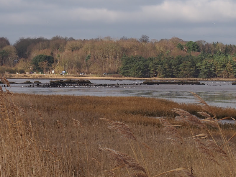
A linear walk along the former trackbed of the Southwold Railway to Blythburgh
The Southwold Railway was a narrow gauge line that linked Halesworth and Southwold. This closed in 1929 but the track bed is still in existence to Blythburgh and makes an excellent walk. The White Hart pub offers a place for refreshment before returning along the same route. Outstanding views across the Blyth estuary and easy walking across heath and woodland make this a well worthwhile excursion.
Southwold to Blythburgh along the former Southwold Railway - Essential Information
Walk Statistics:
- Start location: Southwold
- End location: Blythburgh
- Distance: miles ( km)
- Total Gain: ft ( metre)
- Total Descent: ft ( metre)
- Min Height: ft ( metre)
- Max Height: ft ( metre)
- Walk Time:
- Walk type: Linear
- Walk Grade: Easy
- Terrain: footpaths and old trackbed
Maps:
The following maps and services can assist in navigating this route. There are links to printed maps and links to downloadable GPX route data for importing into navigational software and apps.
- Ordnance Survey Explorer Map
- OS Explorer 231 - Southwold & Bungay
- GPX Route File
Route Verification Details
- Date of Walk: 2017-01-21
- Walk Time: 11:30 to 15:30
- Walkers: Griffmonster, Kat
- Weather Conditions: Overcast to start, blue sky and sunshine for the return journey
Walk Notes
In 1876, an Act of Parliament paved the way to the creation of the Southwold and Halesworth railway. Three years later this was realised when a narrow gauge railway was completed linking the two towns providing access for both passengers and freight to the Great Eastern Railway at Halesworth. For the next 40 years this proved a great success and a Harbour Branch was built with proposals to add an extension through to Kessingland and to upgrade the line to standard gauge being granted. However after the First World War the line went into decline and its death knell came when a rival motor coach service started up in 1929 resulting in the line closing virtually overnight.
With the trains now long gone and the old trackbed still in existence, this presents an accessible walking route between Southwold and Blythburgh and provides a pleasant and interesting stroll requiring little effort to accomplish. At just under four miles in length, the historic White Hart pub at Blythburgh provides a suitable place for refreshment and relaxation before returning back along the same four mile route.
The start of the ramble is at Southwold, and in this instance it was chosen to be on York Road alongside Southwold Common. Although I encourage the use of public transport wherever possible, unfortunately Southwold is not readily accessible from the south of the county of Suffolk and therefore a car is required to reach the town and the best place to park is alongside the Common. This is not the start of the old railway, for that is at Blyth Road where the Southwold Police Station marks the site of the old Southwold Railway Station and goods yards.
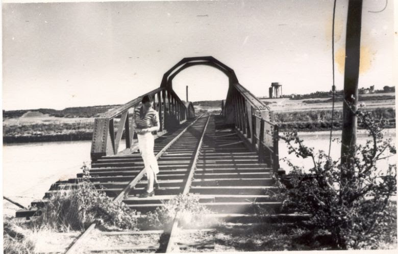
From the Common, a footpath cuts across a golf course and joins Blyth Road at the point where it descends down to the marshes and onward to the footbridge across the river Blyth. Back in the railways days, this crossing used to be a 146 foot span swing bridge and was the largest engineering project on the whole line. The swing bridge was widened in 1907 and lasted until the second world war when it was removed, sometime later being replaced by the present day Bailey Bridge which uses the original bridge plinths. An image of the swing bridge is shown below (please note that I am not sure where this image originates from as it appears to be spread across the internet on a variety of sources - please get in touch if you feel this is infringing your rights and it will be removed).
The Southwold side of the river is known as Blackshore Quay and it is said that the rails of the old Harbour Branch line can still be found opposite the Sailing Club. I have to admit that I have walked the harbour many times and have never noticed these artefacts. Even a recent specific excursion to locate them resulted in a failure to achieve this objective.
Beyond the bridge, just before the track bears around towards Walberswick there is a concrete plinth to the right with a bench sat on it. This plinth was the base to the old Walberswick Station and a commemorative plaque on the bench details its status in history. Beyond this one needs to take the footpath that veers off the main track. The original railway route cut across Walberswick Common at this point and the footpath runs parallel to it. Little can be seen of the old railway other than the side walls to what once was a bridge across a farm track.
The railway was routed around the back of Eastwoodlodge Farm but the humble walker has to perambulate along the Walberswick to Blythburgh roadside for a short distance before a footpath leads back onto the original route at Tinkers Covert. This tree covered heath provides a variety of colours as the track swiftly descends down to the marshes. This appears to be quite an incline for a stream engine and although the route down may have offered a section to pick up speed, the old engines were limited to 16mph throughout the whole route.
At the end of the descent is the curiously named Deadman's Covert, a small thicket with a spooky history. To the left is Deadman's Gulley and somewhere around this area is a location known as Deadman's Cross although its exact position has been lost over the centuries. Details of the history of this name and this location are covered in the main feature to this walk.
The route now follows the perimeter around the Angel marshes with some magnificent views across the broad estuary. Flood defence banks were created in the 19th century to contain the river and reclaim the marshes. This was reverted in more recent years and the river is now allowed to flood across the whole estuary which has returned to its natural state of mudflats and marsh. Parts of the old banks can be seen depicting the main channel of the river. It is interesting that OS maps still contain the rights of way along these banks although they are completely impassable.
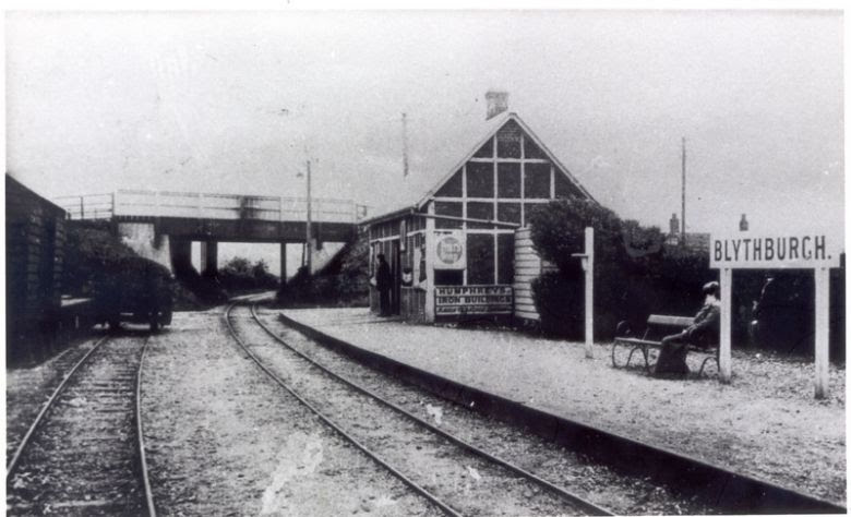
The old railway used to follow the route along the edge of the marsh to a point halfway between the White Hart pub and the present road bridge. On the far side of the road was the location of Blythburgh station although nothing remains of this, the area now an unsurfaced car park. On the pub side of the road is where other railway buildings were sited including a coal shed that is still in existence although pretty much dilapidated these days. The road, the main A12, crossed the railway with a small bridge as can be seen in the image below (please note that I am not sure where this image originates from as it appears to be spread across the internet on a variety of sources - please get in touch if you feel this is infringing your rights and it will be removed).
The road was regularly breached by storm surges up the estuary and no doubt this also inundated the station as well. In 2014 a bund was erected either side of the road to withstand future surges which appears to have been successful thus far.
The railway continued through to Wenhaston where a short stretch has been restored by the Southwold Railway Trust which has the ambition of reopening the line through to Southwold. It then continued on to Halesworth joining what is now the East Suffolk line south of the station. Unfortunately Blythburgh is the limits of what can be walked. It is worth perusing the pages of an 1899 edition of The Railway Magazine where on page 404 is a write up of this charming railway by Scott Damant.
The pub can either be entered from the old trackbed alongside the marshes, where a gate allows entry into the pub garden, or by continuing to the main road and walking back into the village.
The return route is retracing ones steps. Do not think this a chore. One only sees half of the story by walking in one direction and there is so much more to see by walking in the opposite direction. In this instance even the day changed from an overcast grey morning to a bright blue sunny afternoon providing a complete change in the light.

Directions
Easy walk following the old trackbed of the Southwold Railway to Blythburgh
From Southwold Common take the footpath across the golf course which is found just before the water tower. This joins the former trackbed of the Southwold Railway that leads down to the marshes. Keep to this as it leads down to the river, across the bailey bridge and onwards. The broad path these days progresses into Walberswick. At the point where it curves around to the left and where there is a concrete plinth with a bench on it, marking the location of the old Walberswick station, keep straight ahead onto a footpath where a Sandlings Path waymarker directs. This leads in pretty much a straight line across Walberswick Common to the road. To the right is the former trackbed which is no longer accessible at this point.
Cross the road and follow the path alongside the field edge. The Sandling Path then diverges across the field. Keep straight ahead following the road. The path leads into a thicket of trees but is accessible and preferable to walking the roadside. Keep a lookout for a footpath on the opposite side of the road and take this. Although there is no way marker or gate, it is quite obvious, leading off at an angle onto the heath. The path soon joins the old trackbed where a broad easy path leads through the woodland, steadily descending down the incline. At the bottom there is a guley to the left which is known as Deadman's Gulley and to the right the marsh presents itself in its full glory.
Keep to the main track as it slowly curves around the marsh. One can either conitnue to the main road and walk back into the village or use the gate that leads into the pub garden.
Return is the same route.

Pubs
The White Hart, Blythburgh View in OS Map | View in Google Map
- Address
- London Road, Blythburgh
- Website
- www.blythburgh-whitehart.co.uk/
The White Hart was originally built as an ecclesiastical court house in the 13th century but has been an inn for many centuries. Inside there are fine examples of ancient beams and woodwork and also a large inglenook fireplace. Outside is a large garden overlooking the estuary.
It has a ghostly past with an old man in monks habit being witnessed as well as mysterious knocking sounds on an old oak door which leads from the bar to the living quarters. In 1967 a fire damaged the pub and ever since these ghostly occurrences have not been heard or seen.
This is currently an Adnams house offering a menu of good food with daily changing dishes. There is a good range of Adnams beer, wine and spirits with Southwold Bitter, Broadside and Ghost Ship being the three regular ales. Alongside the pub is a smokehouse and village shop where further local food can be purchased.
One may feel somewhat under-dressed when entering this historic old inn but the staff are quite happy to allow walkers to have a drink and packet of savouries rather than a full meal. On this occasion the Broadside was chosen which was a mighty fine example of this full bodied darkish ale.

Features
FolkloreView in OS Map | View in Google Map
One noticeable feature on the Ordnance Survey maps is a section of the wooded heath known as Deadman's Covert located on the southern side of the Blyth estuary between Blythburgh and Walberswick. Such a name on the landscape certainly sparks a question of how it was derived and a few searches of historic publications reveal some interesting clues. The first clue is in the 13th January 1912 edition of The Saturday Review
, in an article written by John Vaughan, the Canon of Winchester and titled Suffolk Lanes
. This makes reference to the road between Walberswick and Blythburgh and declares:
At one spot the lane opens out into a wide stretch of grass and bracken, known in the parish documents as Dead Man's Corner, from the gruesome legend that a suicide was once buried there.
It is difficult to determine the exact location of this landmark. Presumably back in the early 20th century the roads around here were no more than unsurfaced tracks and the present day road linking Blythburgh and Walberswick is most likely not the road referred to in this instance. A more likely candidate is the track the leads from the Tinkers Walk car park down to Lodge Road which leads directly into the village of Blythburgh. This passes close to the area known as Deadman's Covert and would have been the direct route into Blythburgh before the lanes were surfaced and concurs with Vaughans account as he notes that this lane was clearly the ancient roadway between Blythburgh and Walberswick
. This being the case, a good candidate for the location is where, on old OS maps, the track veers away from the railway at the end of Blythburgh Covert and enters a broad expanse of heathland. Although there is no evidence of a substantial corner at this point, it is noted that the present day parish boundary veers away from the Walberswick track and this may have once been the location of the ancient track to Dunwich. This would certainly make a corner.
Going further back in time, a publication from 1754 titled An Historical Account of Dunwich
provides three extracts for perambulations along the bounds of Walberswick. These were official meanders along the parish boundary and this article makes reference to those recorded for the years 1644, 1678 and 1683. They appear to discount the boundary to the north and south which follow the Blyth and Walberswick water courses respectively, and concentrate on the western boundary between these. They describe the route from what was known as Pauls Fen west of the Westwood Marshes, up past Westward Lodge and across its associated parkland, now all farmland. This route is thought to have generally followed that of a medieval road that linked Blythburgh and Dunwich and is discussed in a separate walk In search of the lost Suffolk village of Hethern. An extract from May 6th 1678 perambulation is worth noting, starting from Pauls Fen it then described the Walberswick boundary thus:
...and thence to the Maple by the Park-Side, where there is a Cross upon the Common, and thence right cross to Deadman's Cross, where the Boys heaved Stones to the old Heap, according to their old Custom. On the Meer at Deadmand's Cross (called so by a Man being buried there for Suicide) formerly grew an Ash Tree, whereon were made hundred of Marks by the Townsmen of Walberswich, in old times when they went their bounds.
It is difficult to determine the exact route followed as many features no longer exist. However, the route appears to match the modern day parish boundary and this would indeed merge briefly with the Blythburgh to Walberswick track before departing down to the wide expanse of the estuary which could easily be described as a Mere (or Meer) as it becomes a lake at high water. This would place Deadman's Cross at grid reference TM 46233 74669 which roughly coincides with the estimated location of Deadman's Corner.
Presumably there was a cross marking the location at one time and maybe the change in name is attributed to the cross no longer being in existence. This could well have been destroyed by the infamous puritan William Dowsing who is known to have ransacked all manner of religious icons in this part of Suffolk. John Vaughan notes this in his article where he includes:
Along this road the brutal iconoclast William Dowsing must have travelled in April 1643, when, having destroyed the images and painted glass in Walberswick Church, he passed on to Blythburgh to wreck the beauties of that magnificent edifice.
With the 1678 perambulation being so close in time to Dowsing's passing through this area it would be easy to speculate that the cross was destroyed but the local folk still referred to the location as Deadman's Cross and marked its location with a cairn of stones. The fact that the Boys heaved the stones
would suggest that this was composed of substantial boulders which are certainly not common in Suffolk - could the stones have been the broken up former cross?
Mike Burgess's excellent Hidden East Anglia website also makes reference to the Suffolk Fair
publication of 1972 although I have thus far been unable to locate this periodical. He also makes note in his 1970's Lantern periodical, to a 1911 publication by Carol Christies titled Walberswick Notes
. In each instance he quotes a reference to Deadman's Corner which
... [it is] named from the rumour that once a man had been burnt at the stake there. Local people would hurry up past the spot, and refused to even pass it after dark
To complicate matters there is also a reference to Deadman's Gulley contained in Joan Forman's 1976 publication Haunted East Anglia
where she describes rumours of hauntings related to her by a local horsewoman, which she quotes
...horses always shy away at this place [Deadman's gulley], seemingly upset by something invisible to their riders
It should be noted that prior to the 1823 Burial of Suicides Act (1823 c. 52) it was commonplace that both suicides and executed criminals were buried in unconsecrated ground, usually at crossroads, often on parish boundaries and sometimes the body interred with a stake through their heart. It could well be that this spot was not just the location of a single burial but the place where, over the centuries, many were laid to rest for their misdemeanour's. This would account for the variety of legends that have been associated with the area including the stories of suicide burials and wrongdoers being burnt at the stake.
References

Links and Bibliography:
Gallery
Below are a selection of images taken from from the photo album for this walk. Feel free to browse through these or click on an image to view a larger version in the Gallery.


Summary of Document Changes
Last Updated: 2021-12-07
Distance:Medium, Features:Folklore, Features:Railway Heritage, full-detail, OSmap:231, Railway Walk, Suffolk


0 comments:
Post a Comment