Ouse Valley Way - Houghton to St Ives Circular Walk
|
Wednesday 9 January 2019
|
No comments |
![]()

A 5.5 mile circular walk from Houghton to St Ives using the Ouse Valley Way
A simple and easy riverside walk following the course of the River Ouse. The walk uses the Ouse Valley Way to St Ives, returning via the picturesque Hemingford villages, full of thatched cottages and olde worlde charm. There's plenty of pubs, there's river locks, there's the iconic mill at Houghton which makes this a well worthwhile wander. Make a whole day of it and take in the sights and sounds and, of course, the quintessential English pubs.
Ouse Valley Way - Houghton to St Ives Circular Walk - Essential Information
Walk Statistics:
- Start location: Houghton
- Distance: miles ( km)
- Total Gain: ft ( metre)
- Total Descent: ft ( metre)
- Min Height: ft ( metre)
- Max Height: ft ( metre)
- Walk Time:
- Walk type: Circular
- Walk Grade: Easy
- Terrain: Riverside paths, country lanes and fotpaths
Maps:
The following maps and services can assist in navigating this route. There are links to printed maps and links to downloadable GPX route data for importing into navigational software and apps.
- Ordnance Survey Explorer Map
- OS Explorer 225 - Huntingdon & St Ives
- GPX Route File
Accommodation:
Houghton Mill CampsiteView in OS Map | View in Google Map
- Website
- https://www.nationaltrust.org.uk/holidays/waterclose-meadows-campsite
- Description
- National Trust owned campsite that is located directly in front of Houghton Mill
Route Verification Details
- Date of Walk: 2015-08-22
- Walk Time: 10:30 to 16:30
- Walkers: Griffmonster, Kat, Chaig, Stephen, Bev, Helen
- Weather Conditions: Blue skies and warm summers day
Walk Notes
Forgive me for being nostalgic, but this walk brings back memories from the 1960/70s when family camping holidays would be spent at Houghton Mill with plenty of walks along the river side paths between Houghton, the Hemingfords and St Ives. Little has changed at Houghton since those days. The village is pretty much the same, full of wonky old houses in a quintessential English village setting although the prevalence of hollyhocks that once adorned most gardens now appears to have abated. The village centre pub, the Three Horseshoes is unchanged, as is the post office, the village square with its thatched central shelter and water-pump and the red phone box remain as timeless as ever. Sadly, the farm between the houses on St Ives Road appears to no longer be in existence. It was always a treat to wander up there first thing in the morning for a pint of the freshest milk that money could by. We would wait in the cowshed as the farmer measured out the milk in a jug with the sound of cows mooing in the background. He would then pour it into a glass milk bottle and stamp a silver foil on the top. Gone too is the little corner shop on Mill Street where we would buy I-Spy books (see pic), now replaced by a paved area with a plinth and a bust of a man named as Potto Brown (1797–1871), once the village miller and an eminent nonconformist philanthropist.
The campsite is located at the end of Mill Street and faces the iconic mill that Houghton is famed for. These days both the mill and camp site are owned and managed by the National Trust and the camp site has become an ordered and well maintained touring site with marked pitches and all the modern facilities. Back in the 1960s this was no more than a cow pasture full of coarse grass and wild flowers as well as evidence of bovine occupation during the winter months. There were no pitches, you merely selected an area of grass and pitched ones tent. The only facilities on site were a smelly and crumbling old concrete toilet block that was open to the elements and needed time to pluck ones courage up to visit, and a site shop where ice cream and lollies could be purchased, the memorable treat of the day being the funny face
ice cream on a stick.
What great days. Simple times. The heavy canvas tent our haven for one or two weeks. The great outdoors. The fresh air and the simple sound of the countryside. Alas, the sound is now disturbed by the monotonous rumble of the traffic on the A14 highway which lies about 1.5 miles away. Back in the 1960s and 1970s this road was classified as the A604, and although busy, it carried nowhere near the traffic the present thoroughfare facilitates. The A14 is unrelenting and upon the few nights stay on this occasion one could not help but be reminded of its proximity even in the dead of night. I guess such sound becomes second nature over a prolonged stay or if one is used to such noise during daily life, but for a resident of a quiet Suffolk town it becomes a constant annoyance.
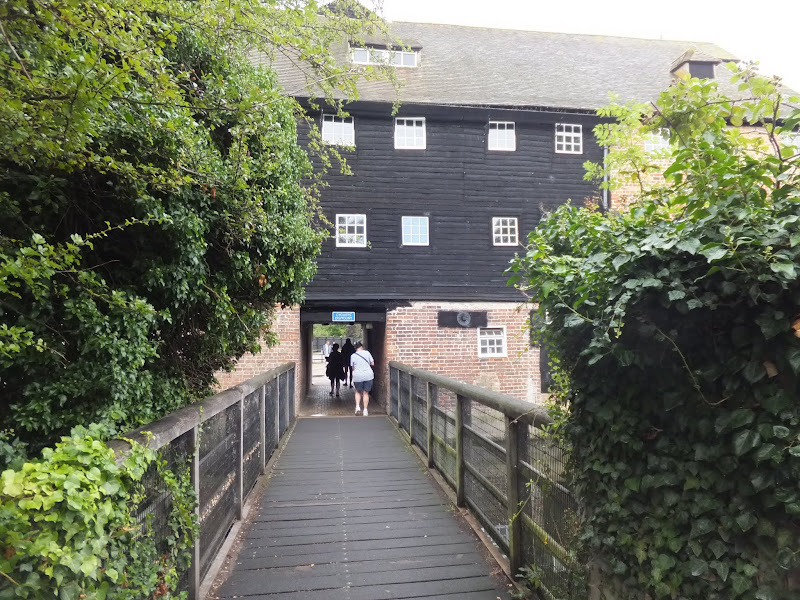
In front of the camping site is the mill pond across which stands the iconic brick and black boarded mill with a waterwheel to the right and a sluice gate to the left presenting a balanced photogenic view. The scene is much the same today as it was back in the 1960s, and indeed decades or even centuries before that. The grass of the campsite leads down an uneven concreted slope to the waters edge where kids and adults can paddle with the more adventurous wading out further in order to swim. Back in the 1960/70s the grassed area around this was reserved for day trippers to park their motors, the limits bounded by a simple rope slung between poles.
The mill pond probably still presents lurking hazards in its waters which as kids we would be warned against. There are plenty of reeds around the edge of the pond that could easily snare a swimmers foot and I do remember being told about a lad who drowned after getting caught up in these. The main hazard was in front of the mill wheels when the water was in flow. This was a very deep area and my dad once had to rescue a swimmer who managed to get into trouble around these, picking the tiring victim up in his canoe and paddling back to the safety of the shallow waters.
The walks around the area have also changed little over the decades, the trail to St Ives still being a broad paved track allowing access for both cyclists and pedestrians. The villages of Hemingford Abbots and Hemingford Grey, commonly known as the Hemingfords, stand timeless in their rural setting. Thatched cottages. Thatched barns. Traditional old pubs. Stereotypical rural England in all its glory. Noticeable in present day are all the thatch sculptures that adorn the cottage roofs. Sculptured cats, bowlers hats and pheasants provide items of interest as one strolls through the quiet streets.
The river bridge at Hemingford Abbots provides particularly relevance to the holidays back in the 1960s. Back then, this bridge had lateral wooden planks throughout its span with small gaps between them where the river would be evident underneath. These have now been replaced with a more substantial surface, although in those days there was never anything unsafe about the boards and nobody ever gave them a thought as they trundled across, the timbers rattling as they went.
During those holidaying years, our family had a sort-of-Labrador-come-57-varieties dog who was scared of bridges. Whether brick, metal, wood or concrete, bridges were something to definitely avoid in his little dog world. Jason was the dogs name and he was as mad and stupid as any over-exuberant Labrador. His main talent was having a pee without halting his walk. No cock of the leg, but a constant drip and dribble as he meandered along, completely oblivious, and much to the hilarity of us pre-teen kids. Of course being impressionable youngsters we would seek to imitate such a talent and I can honestly say my brother was very good at such a feat. It was a pity it was never added as an Olympic sport as he would surely have been a candidate for a British entrant in the 100 metre pee.
Anyway back to Hemingford Bridge. Jason particularly hated the Hemingford bridge. Probably it was the wooden slats that was the cause, the gaps between them making it obvious that it was indeed a bridge. After all he would wander across some bridges without a care in the world until it was pointed out that it was indeed a bridge that he had traversed. In the case of Hemingford, his memory of locations was never too good and, given a good distraction, he would follow the family onto the bridge unaware until he looked down. One could see the cogs of his brain turn as a casual glance to the ground would slowly bring the conclusion that he was not on solid ground. That a river lurked below. There was a gap between himself and the river. At that meant only one thing. He was on a bridge. Yes, a bridge . A BRIDGE. Run for it!
With the revelation firmly confirmed in his brain, he would turn and run back to what he considered firmer ground. Even if he was only a couple of feet from the completion of the traversal, it was always a run back to the Houghton side of the bridge. There, on solid ground he would turn back to gaze at those fools who still stood on the terrifying bridge, unperturbed. And there he stood, whimpering, legs quivering, tail between legs, head down but eyes up as if to say in doggy voice '.....its a b-b-b-bridge'. No matter how much coaxing and bribery was applied, he would stubbornly resist in proceeding and eventually he would have to be dragged, carried or manhandled across to the other side where he would whimper off down the road in every hope that he would not have to return across the bridge later in the day. Little did he know....
One must not forget to mention the locks at Houghton. Many hours of youth were spent here watching the boats navigate their way through. It was always something to marvel over and would never disappoint ones fascination. On this occasion, the fascination was still evident and one could not proceed with ones walk until the waiting boats had successfully passed through. This was all the more rewarding for Kat who was brought up on the broads where locks were something of a rarity in such a flat landscape and hence the mystery of their purpose was slowly revealed.
So take a stroll along this lovely walk. Peruse the images on this site, which includes some from the family photo album including shots from 1949 when my dad stayed at the Mill Youth Hostel. The walk is everything that an English countryside should be. And for the like of my family and myself there's a thousand happy memories from times gone past.
Directions
Riverside circular walk between Houghton and St Ives
From the centre of Houghton village take Thicket Lane that leads off the square by the Three Horseshoes pub. Keep to this ignoring all side turns. At the point where it meets Meadow Lane, the route chicanes across therefore keep headin in the same general direction. The Lane turns to a path that leads through Thicket Wood, borders the river then continues onto All Saints Church as it enters St Ives.
Walk into the churchyard and follow the path around the right hand side of the church, passing through the iron gates that lead out onto The Waits. The road branches here with Crown Street to the left and Merryland to the right. These roads run parallel and both junction with Bridge Street some 300 yards onwards. Turn right onto Bridge Street continue across the bridge and past the Dolphin Hotel on the right, beyond which is a footpath that leads onto the meadows behind the hotel. The path cuts across the meadow and then follows a tree lined ditch and out onto Meadow Lane which is no more than a single lane track before becoming a wider metalled road through housing. At the end of this road, where it meets Mill Lane, a footpath leads straight ahead. This is Love Lane and leads through to Church Street.
Turn right onto Church Street and continue down to the church where a footpath leads off to the left, following the river bank. Alternatively take the first left from Church Street onto Church Lane. At the end of this road, on the left where it junctions with High Street is the Cock pub. Turn right onto High Street and follow the road down to the river where it meets the footpath along the river bank.
Eventually it meets a grassed field where the path cuts across to emerge out onto High Street in Hemingford Abbots. Follow the High Street through the village. The road continues as Common Lane just pass the Axe and Compass pub. Keep to this for approx 600 yards until Meadow Lane leads off on the right. Take this, cross the river bridge and follow the path to Houghton Locks. Cross the bridge and follow the path around to the mill, through the mill walkway and out onto th road that leads into the campsite. Continue down Mill Lane to return back to the starting point at the village square.

Pubs
The Cock, Hemingford Grey View in OS Map | View in Google Map

- Address
- High Street, Hemingford Grey
- Website
- www.cambscuisine.com/the-cock-hemingford
An award wining pub in the centre of the village that is popular with locals and visitors alike. A dedicated restaurant area offers an extensive fish board, meat, game, and excellent home-made sausages. There is a beer garden and occasional beer festivals. There are always a variety of gurst ales on top featuring such diverse examples as Brewsters Hophead, Elgood's Cambridge Bitter, Great Oakley Wagtail.
We could not have picked a better day to visit this pub as there was a beer festival under way with a marquee full of barrels. Admittedly we had missed the best of the weekend event but nonetheless there was still plenty to choose from. Top marks!
Axe and Compass, Hemingford Abbots View in OS Map | View in Google Map

- Address
- High Street, Hemingford Abbots
- Website
- axeandcompass.co.uk/
This 17th century thatched cottage is in keeping with the rest of the village. The interior provides a welcoming atmosphere and features exposed beams, pew style seating and an open fireplace. Food is available. Kids are catered for in a play area and pool and darts on offer in the bar .Two guest ales usually on offer, with local breweries targeted.
In truth, the pub offered shelter from a passing storm. Well a rain shower anyway. A bustling little local full of charm and how a pub should be.
Three Horseshoes Inn, Houghton View in OS Map | View in Google Map

- Address
- Three Horseshoes, Houghton
- Website
- https://www.threehorseshoesinnhoughton.co.uk/
A 17th century inn located on the village square. Accommodation available. Lunchtime and evening meals. Guest ales. Outdoor seating facing the square where one can watch the world go by.
Friendly hostelry and despite having problems with power they still provided a group of us with a decent meal. Changing ales provided some fine drinking.

Features
Houghton MillView in OS Map | View in Google Map
The name of Houghton is synonymous with its iconic five storey timber and brick watermill that straddles the mill stream of the River Ouse. Houghton Mill has been the destination for generations of tourists and visitors to view this impressive structure and bath in its pond waters.
The history of the mill dates back to 10th century when a mill for grinding flour is recorded as being owned by the Benedictine Abbey in Ramsey. Back in those days it was said that the mill presented an obstruction in the river so we may deduce from this that it used the full force of the river and the course with the lock gates was added at a later date.
The present building is thought to date from the 17th century with additions to structure in later centuries. Little is known about the mill or its millers until Potto Brown became the miller in the 1800s. Even then its recognition appears to be secondary to Mr Browns philanthropist activities. Despite this, it is known that he built up a thriving milling business employing eighteen men and sparing no expense in his choosing of millstones to produce the finest of flours.
The mill survived as a going concern until 1928 when it was decommissioned, at which point it had three watermills which survived and were subsequently retained although the millstones and the internal gearing and shafts were all removed.
The redundant mill was put in the ownership of the Water Board who soon leased it to a consortium of villagers for a peppercorn rent. The villagers then sub-let the building to the Youth Hostel Association. This arrangement lasted until 1939 when the National Trust bought the property for £1, allowing the YHA sublet continuing. The YHA considered that the internal wooden structure was a fire risk and provided fire extinguishers and a Davey line for navigation to the upper stories which were used as dormitories.
Mabel Pratt, a YHA guest during June 1949, is quoted as describing the building as
...a grand jumble of old beams, pillars, balks of timbers and machinery, much of it in wood. Floors are at different levels, trapdoors (filled and unfilled in) abound, and stairs are mere broad-treaded ladders. Many of the beds just straddle existing impedimenta
Another guest, Pat Packham, who stayed at the hostel during a cycling tour in 1961 stated
It certainly was a quaint old place and the women’s dormitory on the second floor was reached by a step ladder. The holes in the dormitory floor reminded me of Crickhowell [Presumably this was another YHA asset in the Brecon Beacons].
Finally, in 1976 another visitor remarked
This is probably the only hostel in the world where you are likely to be knocked down by a motor cycle while carrying your supper from the warden’s kitchen to the dining room – there is a public right of way (strictly a bridle way) through the hostel
The Notional Trust closed the mill in 1982 when refurbishment and reinstatement of the mills components was undertaken with financial assistance from the EU and NAtional lottery. The long tenure as a youth hostel finally came to a close and the mill was reinstated as a fully functional mill. This continues to the present day and the milled flour is sold on a commercial basis.
References

Gallery
Below are a selection of images taken from from the photo album for this walk. Feel free to browse through these or click on an image to view a larger version in the Gallery.


Summary of Document Changes
Last Updated: 2021-12-07
Cambridgeshire, Distance:Short, Features:Mills, full-detail, OSmap:255, Ouse Valley Way, Riverside Walk


0 comments:
Post a Comment