In search of the lost Suffolk village of Hethern
|
Friday 29 November 2019
|
1 comment |
![]()
A 5 mile walk through Dunwich forest to the medieval site of the lost village of Hethern
Dunwich forest is always a good place to walk and find peace amid the fora, fauna and wildlife. There are information boards that provide details of this ever changing world of nature but there is nothing about its history. Little is known of the medieval village of Hethern or the landmarks of Stonehill Bridge and Stonehill Castle which are recorded in the 15th century Westleton Extents. This document records that they stood aside a now lost road directly linking Dunwich to Blythburgh and which cut across the marshes.
Dunwich Forest Trail - Essential Information
Walk Statistics:
- Start location: Dunwich
- Distance: miles ( km)
- Total Gain: ft ( metre)
- Total Descent: ft ( metre)
- Min Height: ft ( metre)
- Max Height: ft ( metre)
- Walk Time:
- Walk type: Circular
- Walk Grade: Easy walking
- Terrain: Forest trials
Maps:
The following maps and services can assist in navigating this route. There are links to printed maps and links to downloadable GPX route data for importing into navigational software and apps.
- Ordnance Survey Explorer Map
- OS Explorer 231 - Southwold & Bungay
- GPX Route File
Route Verification Details
- Date of Walk: 2015-02-08
- Walk Time: 11:30 to 14:30
- Walkers: Griffmonster, Kat
- Weather Conditions: Bright winters day
Walk Notes
The walk starts out from Dunwich and initially follows the Sandlings path before diverting across the marshy area around the Dunwich River where the medieval village of Breggestreet or Bregge was said to have been located. The route then crosses the road and continues through more forest eventually following The Helena Trail. St Helena is a small hamlet of houses in the forest and its names origins are unknown. This part of Dunwich forest is a 20th century creation, currently managed by the Forest Commission. Prior to this, the area was heathland. From this point onwards one can wander without seeing a soul. Few venture to these forest depths despite the thousands that visit the woodland. The walks around Dunwich and the official Coast Path routes are traipsed by throngs of people most weekends, but in this neck of the woods one finds peace. Despite the Helena Trail waymarkers it is either too far or not publicised for most to investigate.
So, it is worth knowing, as one steps slowly onwards, of the ghostly tales that are told of these parts. Don't be afraid, it is a friendly old forest in reality. Even so, back in 2011, a couple walking the Trail purportedly witnessed a pair of disembodied legs wearing dark trousers and boots. This story was recorded on the Eerie Places website created by Essex author Stewart Hare. Unfortunately the website is no longer active and the original page had no citation as to where the story came from. The same story is referenced on Nicola Miller's blog from 2014 and also occurs in the Paranormal Database, again without citation in either case. It could well be that any one of these pages was the original source, or even replicated from this very Griffomsters Walks page and thus is a self-sustaining piece of folklore originating from the web itself! It is certainly not a tale that is widely known locally and despite living in the area for over 20 years, it is not a tale that has been related to me by local folk. Therefore without any provenance or citation of source I think we need to take this with a pinch of salt.
Unlike the ghostly horseman that is reputed to haunt this area which I have heard many a time from local folk who attest that the story has been passed down through the generations, and with one acquaintance attesting that his father had witnessed the ghost himself. The old heathland either side of the marshes is also said to be haunt of the ghost of John Brooke, a 17th century bad tempered lord of the manor who is said to ride his horse across the heathland around Westwood Lodge. Now I thought this was probably just a story made up by 18th century smugglers to deter prying eyes but my acquaintance firmly believed his fathers words when he stated that he witnessed this ghostly apparition bounding across the Blythburgh to Westleton road.
The marshes are also said to be an area for so called Hobby Lanterns or Will-o-the-Wisps. Phantom lights which are reputed to lure victims away from the well trod paths and tracks. Such lights are often linked with marshy areas and some say they are just ignited marsh gas, although how gas ignites in such a damp environment is unexplained. On this occasion there was a distinct lack of disembodied legs following us, John Brook must have been attending other business and Will-o-the-wisp was staying away.
Throughout the forest there are numerous information boards describing the flora and fauna of the area. They are discreetly placed to add interest and education to those visiting the forest. However, one thing that is notable by its absence is the lack of local history on these boards. Dunwich is festooned in history and one would expect the general area would also have tales to tell from centuries past. The forest as we know it today is a 20th century creation, the old woods of Eastwood and Westwood that constituted the ancient forest are now long gone, the the former taken by the sea and the latter but a name on the landscape. It was a chance reading of an old document concerning the Blything hundred that revealed more secrets of the past.
Back in the medieval days when Dunwich was a major port and probably the largest town in East Anglia, the administrative centre was then at Blythburgh. Naturally the two towns were linked together by a road that cut through what is now the forest, across the marsh, past Westwood Lodge and up to Blythburgh. Where this road crossed the marshes there also stood a village by the name of Hethern, together with a fortification known as Stonehill Castle and a bridge across the watercourse called Stonehill Bridge.
This discovery of this information provided the impetus for a search for these ancient locations. A search to see if we could stumble upon something overlooked for centuries. Maybe a lost village with a lost tribe that had lay undiscovered for centuries. Maybe not. But even to locate a semi buried stone, or a remnant of domesticity, or anything to indicate that, once upon a time, there was some habitation in this area would be something of an achievement.
The location is at the northern edge of the forest where it meets the Westwood marsh. The area is peaceful with the landscape providing hills up from the marsh and a view across the flat wetland. The hills are covered in bracken as the trees give way to the open landscape. A hide stands aside a watercourse that bounds the marsh. But, no long lost village. No long lost tribe. No semi buried stone marking a former building. Nothing to indicate that there was a community here, long, long ago, let alone a castle. One could only wander in ones own imagination to find the village that once stood here, somewhere, some place on the marsh. We mused around looking for something to fire that imagination. Nothing.
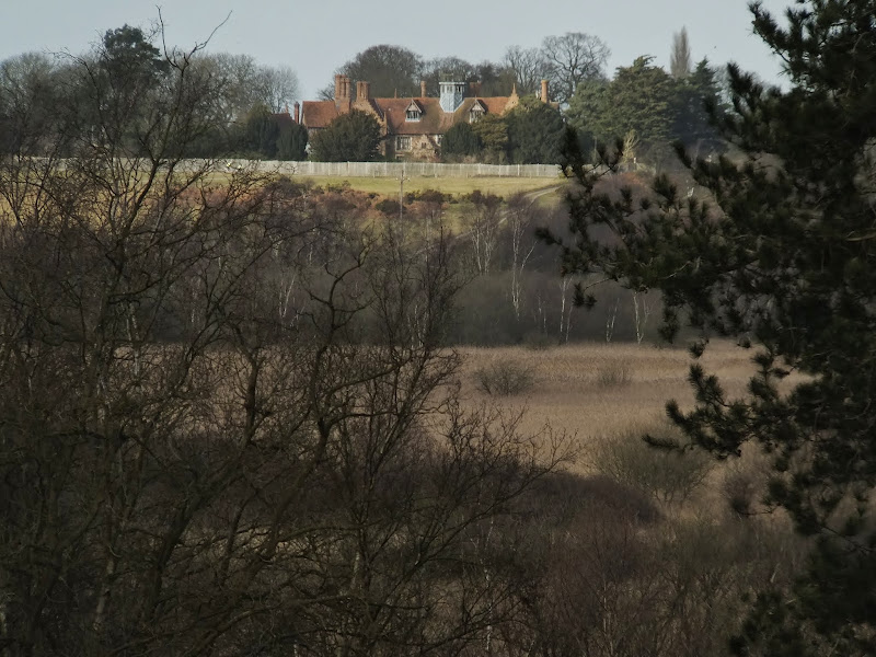
After half an hour of wondering and pondering there was nothing left to do but return to Dunwich. The route back mounts a steep hill back into the forest. At the top one can catch ones breath and gaze back across the marsh. It is at this point that a revelation filtered into ones head. Through the gap between the trees one could see Westward Lodge directly opposite on the far side of the valley, and from this distinctive building a track lead down to the marsh. This was a direct line from Westward house, across the marsh and onto the track we now stood upon, which then lead directly to Dunwich. This had to be the old road. Down on the marsh had to be the location of Hethern and the hill top would have been a superb place to construct a castle. It all seemed to fit together. Although there was no clear evidence from all those centuries ago, it did all seem to fit together. We had located Hethern!

Directions
The walk uses the Sandlings and Suffolk Coast Path to get to and from the St Helena Trail which is marked throughout with prominent markers
Leave Dunwich westwards towards the Church and then take the footpath on the left hand side of the road just beyond the war memorial and marked with the Sandlings moniker. Keep to this track until it meets with Sandy Lane Farm on the right. Take the footpath down the near side of the farm which leads through a marshy area around the Dunwich river. There are several bridges and a board-walk across this section before the path leads up a hill to the road. This area is thought to be the location of the medieval village of Breggestreet.
Cross the road and a proceed onto a path that leads into the woodland. Bear round to the right and head for the car park where an information board displays the forest tracks and trails. Head down the path to the left of the information board and through a metal gate. Follow the trail to the left which is marked out by the green arrows on a circular white background. At the end of the path, the trail turns right and heads through the forest. Keep to this track until it comes to a large metal gate across the track which leads out onto the road at St Helena. Turn right onto the road, then take the track on the left down towards some nissen hut type buildings. Go through the metal gate and continue along the track as it curves through the forest. Eventually it will come to a point where a marker points to the right, with a further marker just beyond that point to the left. Take the path indicated by the first marker which leads along the northern edge of the forest with the Westwood marshes on the left.
Not far along this path, another marker will direct to the right and up the hill, with another path continuing along the bottom of the hill and a wooden hide constructed on the left by a straight watercourse. Keep to the marked track on the right, proceeding up the hill to where there is a viewing point across the marshes. At this point it is worth perusing the area and taking in the sights. The area around this hill was probably the site of Stonehill Castle and the medieval village of Hethern would have been located on the marsh. Looking across the marsh one can see the distinctive Westward lodge on the horizon, atop the hill above the marsh. Just beyond the viewing point, a track leads down to the marsh. This is probably the route of the medieval Dunwich to Blythburgh road which crossed the marshes by way of Stonehill Bridge and continued up to the right of Westward lodge. If one looks carefully across the marsh the old track up to the lodge is still there, leading down to the marsh.
Continue along the marked trail heading back into the forest. Eventually it comes to a point adjacent to a cottage where a marker directs the trail to the right. Ignore the marker and turn left, past the cottage and over the cattle grid until it meets another track. Turn right and follow the track. This is now the route of the Suffolk Coast Path which will lead back into Dunwich, turning left when it meets the road which continues past the church and the pub.


Pubs
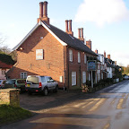
The Ship, Dunwich View in OS Map | View in Google Map
- Address
- The Ship, Dunwich
- Website
- https://www.shipatdunwich.co.uk/
The Ship is part of a portfolio of inns, restaurants and hotels owned and managed by Agellus Hotels Limited which specialises in distinctive properties offering quality food and accommodation and guest ales.
This 16th century Inn was previously known as The Barnes Inn after the family that once owned the village. There is a roaring wood fire in winter, and a garden complete with a 300 year old knarled fig tree for the summer. The pub offers the usual Adnams ales as well as regularly changing guest ales from a local small Suffolk or Norfolk brewers including Mauldons, Blackfriars and Earl Soham.
The pub is said to be home to a ghost in the attic room. A tale told by a previous owner relates how one dark night she awoke to find a mysterious ghostly figure sitting on the end of her bed. The figure got up and walked through the wall. To add to the intrigue, years later it was found that there was a hidden door in this wall which led to another room which the landlord had no previous knowledge of.
Always a good place to visit in the winter when the fire is roaring and warming. A good selection of local ales is usually on offer as was the case on this occasion, with the rich, smokey and fruity Red Herring ale from Green Jack, a worthy reward after a winters walks.

Features
The lost village of HethernView in OS Map | View in Google Map
The location that this feature concerns is the northern edges of Dunwich Forest where it abuts the Westwood marshes, namely the area of Foxburrow Wood, Little and Great Dingle. Despite the enveloping forests name, this land is part the northern extremity of Westleton parish. Dingle marshes, that adjoin the coastline, are currently part of Dunwich parish although these were also once part of Westleton's land which can clearly be seen on the OS maps from the late 19th century. Today the area is covered by Dunwich forest, most of which is a modern creation of managed woodland currently under the stewardship of the Forestry Commission. Prior to this, the area was heathland with small sections of woodland such as at Foxburrow Wood and the original Dunwich forest known as Eastwood, or Kings Wood which is now long lost to the sea.
The source of most of the information contained here is from a Thesis entitled Blything Hundred: A Study in the Development of Settlement AD. 400-1400 which was prepared for the Department of English History at the University of Leicester by Peter M Warner. Written in 1982, this document made ample reference to sources held by Ipswich Records Office and many notable historic publications, some of which are referenced in this account. This publication is worth reading in its own right and covers a much wider scope than the details focused upon here, namely the medieval village of Hethern and the nearby Stonehill Castle.
The first reference to Hethern in Mr Warner's publication is on page 16 and is a speculation that defences around Pallifen, also known as Pauls Fen and located in the present day Westwood Marshes, were built to protect the village of Hethern, citing a document titled The Westleton Extents, held by the Ipswich Records Office (IRO) (HA3O:372/2 fol.3, 56b, 71 & 85b). This document places the village south-west of the old road which once ran directly between Blythburgh and Dunwich across the salt-marshes of Brakenest Common
which interprets to a grid reference of TM 466728. A map on page 8 of the Thesis helps to put this into perspective and depicts a road that runs directly to Blythburgh from Dunwich church, passing across the marsh, then up past Westwood Lodge on the opposite side of the valley. A present day track exists from Westwood lodge down to marsh which proceeds to the immediate east of the lodge up to the Walberswick road. Old OS maps from the 19th century indicate it continuing through to Blythburgh appropriately meeting up with Lodge Lane. It is therefore tempting to surmise that this is the route of the medieval road. However, more research concerning the location of Deadmans Cross which is documented on the Southwold to Blyburgh walk on this site does draw doubt upon such a conclusion. From the late medieval period Westwood Lodge was surrounded by a hunting park and this road may be dated from this period. The Deadmans Cross research appears to point to a crossing of tracks which would have been at the Walberswick parish boundary to the east of the present track. Either way, the general position of the road would have been in this vicinity and where it met the marsh, was the location of Hethern. To the east of this was Stonehill Castle and the river flowing through the marsh is crossed by means as Stonehill Bridge. None of this exists in present day, and there is no information about these historic features offered by the numerous information boards that are placed throughout the forest. It is interesting to note that viewing the Google earth image, one can clearly see what appears to be raised banks around the area purported to be the location of Hethern. Whether this is a modern feature or the sunken outlines of the old defences is unclear. These do coincide with features on the 1900's OS Map which appear to represent defence banks.
The IRO document also states that in the year 1463, these defence banks were already described as ancient and both Hethern and the village of Breggestreet, situated closer to Dunwich, just north of the present day church, were both in a ruinous state. Dunwich, prior to the 14th century, was one of the primary ports in East Anglia, with a wealthy trade and an important religious centre and borough with a royal charter. Major loss of land by erosion is recorded in the Domesday book with subsequent storms and surges reducing the towns importance and prosperity. One could guess that this loss affected trade to the wider area and may well be a reason why such satellite communities as Hethern soon fell into ruin.
The Domesday Book provides a reference to the village of Alneterne which is thought to be an alternative spelling for the same village. This spelling is also used on pages 58-59 of the 1905 book The Manors of Suffolk which mentions Alneterne as a manor of Dunwich.
By the time of the Survey the burgesses had increased to 236, of whom 80 were attached to the Manor of Alneterne belonging to the Abbot of Ely. There were 178 poor persons in the town (pauperos homines}, and the number of churches had risen to three, rendering 4 pounds 10 shillings. In the Confessor's time the manor rendered "10, but in the time of the Domesday Survey it was valued at "50 and 60,000 herrings by way of gift.
Returning to the Domesday Book, there are references in the Thesis to the translated copy of the Domesday Book used in the 1911 publication of Victoria County History for Suffolk Vol.II stating that Hethern was described as having half a church. Thus far I have been unable to find this reference in the the publication as found online. However there is a reference in Walter Arthur Copinger's 1904 publication of County of Suffolk , where on page 32 it states:
Alneton (Alrietune) ? in Blything Hund. Land of St. Etheldreda. Held as a manor in King E.'s time 2 caruoates. A church with 2a., 2a. meadow. To this manor belong 20 burgesses in Dunwich and they dwell upon 14a., and to the township belong 3 freemen dwelling in Besemere (?) with 14a. Dom. [Domesday Book, 1783] 3856.
The indication that this was the Land of St Etheldreda relates to daughter of King Anna, who became queen and foundress and abbess of Ely. This suggests that Hethern was part of the lands of Ely Abbey which is in agreement with the extract from The Manors of Suffolk.
Stonehill castle comes from another reference in the 1463 Westleton Extent (IRO., HA3O:372/2.fol.87) where it states Stonehill Mount on Castle Heath
. The thesis also states that this location is marked as a circular wood on the first series OS map and can be placed at TM 47157270, although this certainly isn't marked on the historic on-line OS maps from that period.
A reference on page 25 of the 16th century The itinerary of John Leland also refers to a castle which could well be Stonehill Castle.
Mr. Hopton of Blitheburg told me that there appere at a litle village caullid Wenhestun about half a mile above Blitheburg on the same side of the ripe that Blitheburg is on certen dikes and tokins wher sum great notable place. And sum devine that ther was sum great place of the kinges of the Easte Angles, and that ther about was the olde abbay that Bede spekith of in historic.
Sum say that the castelle and abbay that Bede spekith of was on the farther side of Blithe, wher a creke cummith yn a mile from Dunewiche, and about a mile and a half from Blitheburge at a place caullid . . . hille wher yet appere dichis and hilles, wherof one is notable : and this is more likely to be the place that Bede spekith of.
The directions a creak a mile from Dunwich and about a mile and a half from Blythburgh
certainly fit in well with the location close to Hethern.
It interesting to note that in Thomas Gardners 1754 publication An Historical Account of Dunwich there is a passage on page 111 under the heading of Dingle that states
Dingle Great, and Little, lying between Dunwich and Walberswick, appertain to Westleton, and each have one Dwelling, convenient for a Husbandman.
By Tokens, the former has been accommodated with more Edifices, On the Hill are the remains of some Structure, supposed to have been for Signals to People at Sea.
At the House is a Stone Coffin misused for a Trough'.
Could these remains of some structure on the hill have been the castle? This is unclear as there are also two hills at Dingle named Dingle Great Hill and Dingle Little hill which would be closer to the coast although it is unknown if any structures ever stood on these. The house with the stone coffin could also refer to what is known these days as Stone House. The fact that we have Stone House in the vicinity of Stonehill Castle and Stonehill bridge could indicate some connection. Stone certainly isn't a common mineral in these parts.
There are few other references to either Hethern or Stonehill castle in later publications and these places appear to have been forgotten about, even in the local knowledge of the folk around the area. A post medieval brickworks did exist in this area which may have destroyed any evidence of Hethern or the castle. As far as can be determined from on-line resources, no archaeological digs have ever taken place in this area. It would be interesting if such an activity went ahead as to what it may turn up. Unfortunately this lies in the shadow of Dunwich which is so rich in archaeological remains and garners the main attention.
References
- BLYTHING HUNDRED: A Study in the Development of Settlement AD. 400-1400
- Open Domeday Website page for Alneterne
- Victoria County History for Suffolk Vol.II, Page, William,1907,
- County of Suffolk, Copinger, Walter Arthur, 1904
- The itinerary of John Leland, Leland, John, 1908
- An Historical Account of Dunwich, Gardener, Thomas, 1754
- Dunwich Museum Website
- The East Anglian Vol 3, S. Tymms, 1869, pp304-7
- Dunwich: a tale of the splendid city, Bird, James, 1828
- The Suffolk traveller, Kirby, John, 1735
- Dunwich website

Gallery
Below are a selection of images taken from from the photo album for this walk. Feel free to browse through these or click on an image to view a larger version in the Gallery.


Summary of Document Changes
Last Updated: 2021-12-07


Fascinating read. The forest in and around Dunwich is one of my favourite places to be. Anything historically linked is always of great interest to me. I will definitely be doing that trail though, in the very near future.
ReplyDelete