Coast Path around The Wash
|
Wednesday 5 December 2018
|
1 comment |
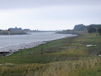
![]()

An overview of a walk around the Wash from Boston to Kings Lynn
Three rivers flow out into the Wash, namely the Welland, the Nene and The Ouse. Public footpaths follow the defence banks that border these rivers and the marshes that adjoin the coastline in between. The A17 provides bridges across these watercourses at Fosdyke, Sutton Bridge and West Lynn respectively. The walks are typical of this fenland area with vast open landscapes and huge skies which provide a unique charm to this part of the English coast.
Boston to Kings Lynn Walk - Essential Information
Walk Statistics:
- Start location: Boston
- End location: Kings Lynn
- Distance: miles ( km)
- Total Gain: ft ( metre)
- Total Descent: ft ( metre)
- Min Height: ft ( metre)
- Max Height: ft ( metre)
- Walk Time:
- Walk type: Linear
- Walk Grade: Easy walking but long sections with no shorter alternatives
- Terrain: The walking is predominantly along defence banks using public footpaths
Maps:
The following maps and services can assist in navigating this route. There are links to printed maps and links to downloadable GPX route data for importing into navigational software and apps.
- Ordnance Survey Explorer Map
- OS Explorer 261 - Boston
- Ordnance Survey Explorer Map
- OS Explorer 249 - Spalding & Holbeach
- GPX Route File
Walk Notes
There are recognised footpaths around the Wash that enables one to walk the coast between Boston and Kings Lynn. As the Rivers Welland, Nene and Ouse flow out into the Wash it necessitates navigation to the first bridge across each of these rivers, at Fosdyke, Sutton Bridge and West Lynn respectively. Only West Lynn offers an alternative ferry crossing and this cuts a paltry three miles of paths to get around to Kings Lynn.
The information on this page was garnered during the investigation for 4 days of walking around The Wash during September 2015. The walks will appear on this site in the coming months with full details of directions, features and pubs. This overview serves as a guide to any walker who has the intention of walking around the Wash. It should be noted that there are no shorter alternatives as facilities and public transport are severely limited to the area immediately around the main A17 trunk road. This means that once one embarks upon each section then you are committed to continuing to the end or turn back and retrace ones steps. As such, with mileages varying from 11 to 18 miles, these sections should only be undertaken by fit and healthy individuals and adequate supplies of water and food taken for such a distance.
The landscape throughout this coastal section that links the counties of Lincolnshire and Norfolk consists of marsh, flat farmland and defence banks with some distant views of the sea. On clear days both the Lincolnshire and the North Norfolk coasts can be viewed on the horizon. A lot of walkers have described this part of the British coast as monotonous, however it has its own charisma and one can only be impressed by the quietness and solitude together with the wide open skies that can be enjoyed throughout. A notable feature of this walk is that it follows the legendary route that King John's entourage undertook in the 13th century when they lost his treasure, including the crown jewels, to the marshes on the incoming tide. The treasure has never been found so maybe some lucky walker will stumble upon it some day.
The route can be broken down into distinct sections determined by the river crossings. These are listed below, and the links will take you to the individual walk.
Boston to Fosdyke: This 11 mile walk makes use of the Macmillan Way throughout. On this occasion a section alongside the Haven, close to Boston was almost inaccessible. This required a certain amount of perseverance to push through the uncontrolled undergrowth as well as re-routing across a riverside meadow - it would appear to have been a section of closed path that had not been cleared since it had reopened, hopefully this will be resolved in the near future.
There are few public transport links to Fosdyke, with a solitary bus service run by the Brylaine Bus Company that runs once a day in each direction between Boston and Long Sutton. An alternative is to walk an additional 7 miles alongside the river into Spalding where there is a regular bus service linking the town and Boston.
Fosdyke to Sutton Bridge: This is an extensive 18 miles walk with no place to break so needs to be undertaken by experienced and fit walkers. The path follows alongside an extensive military bombing range but is always open to public access - keep to the landward side of the defence bank on the track provided and do not stray onto the defence bank when the red flags are flying. On the western side of the range the track passes through barriers which prevent access when an helicopter is about to use the adjacent landing pad. This requires the walker to wait until the operation is over when the barriers are lifted. The OS map indicates that the public footpath around Fosdyke Wash proceeds around inland defence banks rather than keeping to the coastal bank. However there is access along the entire coastal bank and there is nothing to prevent or deny the public from walking these sections.
As mentioned above, there is very limited public transport to Fosdyke with the only alternative being an additional 7 miles walk from Spalding which would make this a substantial 25 mile walk. Although the flat terrain may appear easy, the hardened defence banks does put a severe toll on feet over such distances.
Sutton Bridge to West Lynn: This 14 mile section is known as the Peter Scott walk after the eminent a British ornithologist, naturalist and painter. A road leads out from Sutton Bridge to the Peter Scott lighthouse where there is a car parking area which is used by many dog walkers and casual strollers alike. Few venture far beyond this and one can probably walk all the way around to the river Ouse without seeing a soul. The last couple of miles into West Lynn is through the riverside meadows although these are bounded by thick hedgerows that severely limit the views of the river and as such provide a disappointing end to the trek.
West Lynn to Kings Lynn: There is a ferry at West Lynn across the river Ouse but it is worth walking the additional 3 miles into the port of Kings Lynn. In this instance a walk around the historic attractions of the town was also included and is worth perusing.
Transport
The principle bus services throughout this section are the Stagecoach (formerly Norfolk Green) 505 service between Kings Lynn and Spalding linking West Lynn, Sutton Bridge and Holbeach with a regular 20 minute service. The Brylaine bus company also provides an hourly service between Spalding and Boston and offers a daily service between Long Sutton and Boston via Fosdyke. This is to serve a school contract and the morning service is the return from that contract with an afternoon service to complete the days contract. As such this service cannot be guaranteed that it will run in the long term and it certainly does not appear to be well patronised. The locals in the Ship Inn at Fosdyke had no knowledge that such a service was running, claiming that all bus services to the village ceased many years ago. It should be noted that there is no designated bus stop at Fosdyke, but on phoning the bus company they stated that one should choose a location close to the Ship Inn pub where the bus has ample opportunity to pull in, from where one can hail the driver when the bus comes into view. This is the very busy A17 and extreme care should be taken.
Refreshments
There are no places to break for refreshments other than the ends of each route. Unfortunately the local area has seen many of the local hostelries cease trading for good. West Lynn currently has no public houses, Sutton Bridge has shops and a couple of bars close to the Bridge and Fosdyke boasts the Ship Inn which appeared to be well frequented. If the route through to Spalding is taken, then it is well worth seeking out The Priors Oven, a town centre micro pub that has made use of the 12th century former priory bakery. The small octagonal building is worth admiring in itself, and inside it offers a central round bar serving a variety of ever changing guest ales including their own Austendyke brews.
Accommodation
There are a few campsites throughout the area. The one chosen for this specific walk expedition was Delph Bank at Fleet Hargate which was central to the whole walk and provided the best bus connections. This was an excellent secluded site, well maintained, clean, friendly and close to the bus stop at Fleet Hargate village serviced by both Norfolk Green and Brylaine buses. It should be noted that this is an adult only site. Fleet Hargate currently hosts only one pub, the Rose and Crown which appeared to be little used during the weeks stay in the village. Within easy walking access there is also a very good Chinese restaurant called The Beijing Palace which is located at the eastern end of the village on the main A17.
Adjoining Walks
There is a commitment by Government, laid down in legislation, to provide an all England coast path by 2020. Details of this particular section and the adjoining sections have yet to be published but it is thought the route will use the existing paths detailed on this page. To the north of Boston one can walk the Lincolnshire coast through to the Humber bridge - details are described in The Lincolnshire Coast Path although access between Boston and Gibralter Point is limited and an alterntive route inland route is suggested. Going eastwards there is the Norfolk Coast Path which starts at Hunstanton although coastal access is limited between here and Kings Lynn. An alternative route is to use the Iceni Way, a Ramblers Association designated route that makes use of existing footpaths.
Directions
The route overview is described in the notes
Full details can be found on individual walk pages on this site
Links and Bibliography:
Walks around The The Wash Coast Path
An index of the walks around the long distance path of The The Wash Coast Path that are contained on this site. Each walk details pubs en route, transport linking start and end and features to look out for.
 An 11 mile along the sea defence banks from Boston to Fosdyke...Read More Long
 An 18 mile along the sea defence banks from Fosdyke to Sutton Bridge...Read More Hike
 The 14 miles Peter Scott Walk from Sutton Bridge to West Lynn, crossing the border from Lincolnshire to Norfolk...Read More Hike
 A short walk from West Lynn to Kings Lynn including the Lynn Town Trail...Read More Short
Summary of Document Changes
Last Updated: 2021-12-07
Distance:Multi Day Hike, England Coast Path, full-detail, Lincolnshire, Lincolnshire Coast Path, Long Distance Trail, Norfolk, OSmap:249, OSmap:261


Regarding the transport links on this walk, I walked from Sutton Bridge to Fosdyke. Rather than walk into Spalding for a bus as you suggest there is a frequent service from the village of Sutterton, which is a good deal closer than Spalding and can be reached along quiet roads. The bus route is Brylaine 13.
ReplyDelete