Norfolk Coast Path Extension
|
Tuesday 29 July 2014
|
No comments |
![]()
A 21 mile extension has recently been completed to the Norfolk Coast Path taking it through to Sea Palling
As part of the English Coast Path project, the Norfolk Coast path has now been extended to Sea Palling with waymarkers and direction signs being added during the first half of July. This includes a redirected section between Beeston and Cromer that now follows the coast rather than its original route which headed inland through the hills above Cromer.
Norfolk Coast Path Extension - Essential Information
Walk Statistics:
- Start location: Sheringham
- End location: Sea Palling
- Distance: miles ( km)
- Total Gain: ft ( metre)
- Total Descent: ft ( metre)
- Min Height: ft ( metre)
- Max Height: ft ( metre)
- Walk Time:
- Walk type: Linear
- Walk Grade: A mixture of cliff top footpaths and beach walking. A small amount of roadside walking
- Terrain: Sandy Beaches plus well used cliff top paths
Maps:
The following maps and services can assist in navigating this route. There are links to printed maps and links to downloadable GPX route data for importing into navigational software and apps.
- Ordnance Survey Explorer Map
- OS Explorer 252 - Norfolk Coast East
- Ordnance Survey Explorer Map
- OS Explorer OL40 - The Broads
- GPX Route File
Walk Notes
It has been known for sometime now that one of the first stages of the All England Coast Path would be the Norfolk coast. Well, it has started to happen. Without any fanfare or announcement the waymarker and sign posts have appeared along the Norfolk Coast declaring Norfolk Coast Path and enabling the walker to continue from Cromer all the way through to Sea Palling. This does not officially open until the winter of 2014 as detailed by the Norfolk Trails website. Even so, it is still currently accessible to the would be coast walker.
The response from the Secretary of State to the petitions and objections for the path can be viewed at www.gov.uk.
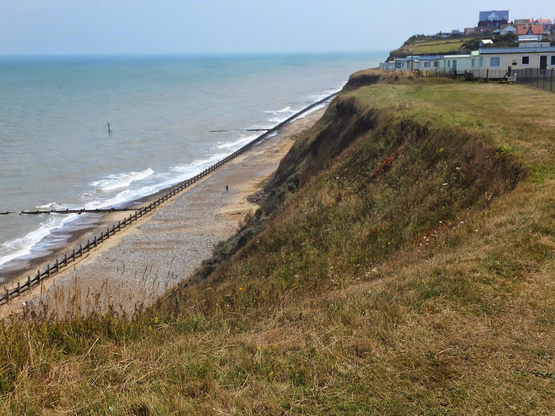
The route has used a mixture of existing public and permissive footpaths and the legislation will enable the path to recede landwards with any ensuing erosion. Some of this can already be seen between Overstrand and Trimmingham where erosion has already taken some of the existing footpath forcing the walker to rightfully take a route at a safe distance from the cliff.
In addition the route taken from Sheringham to Cromer has now been altered to take a coast route rather than diverting away from the cliff top and up to Roman Camp before coming back down to Cromer. This certainly is more in keeping with the coast path status.
The extension provides a contrast to the North Norfolk section which is typified by salt marsh and flood defences. From Sheringham the scenery changes to tall cliffs and broad beaches. Beyond Happisburgh the cliffs recede and the final section is low level dunes with acres of sandy beach. Although the path uses a mixture of both cliff top paths and beach, it can nonetheless be completed along the beach throughout providing the tides are suitable.
The sections where the official route does take to the beach there are also alternative permissive paths along the cliff top. These can be used when high tides prevent access, especially the section in front of Bacton which is regularly cut off by tides. Walks on this site provide details of both cliff top paths and beach routes.
Transport Connections
The route from Hunstanton through to Cromer continues to be served by Norfolk Greens Coasthopper service. Beyond this there is a regular service that links Cromer, Overstrand and Mundesley served by Sanders Coaches. The far reaches of the new path out to Sea Palling are unfortunately not currently well served at all. There is a bare bones service that offers just two weekday journeys between Happisburgh and Sea Palling during the morning and two in the opposite direction during the evening. Saturdays , this is reduced to a single journey in each direction. There is no service that connects Mundesley to Happisburgh which would necessitate a connection with other services from North Walsham.
Beyond Sea Palling
Consultations are already underway to extend the coast path through to Hopton with the expectation of this being opened during 2015. This section can already be walked by both beach or navigating along the low cliffs and through the housing and holiday camps that adorn the seafronts of Caister and Scratby.
Directions
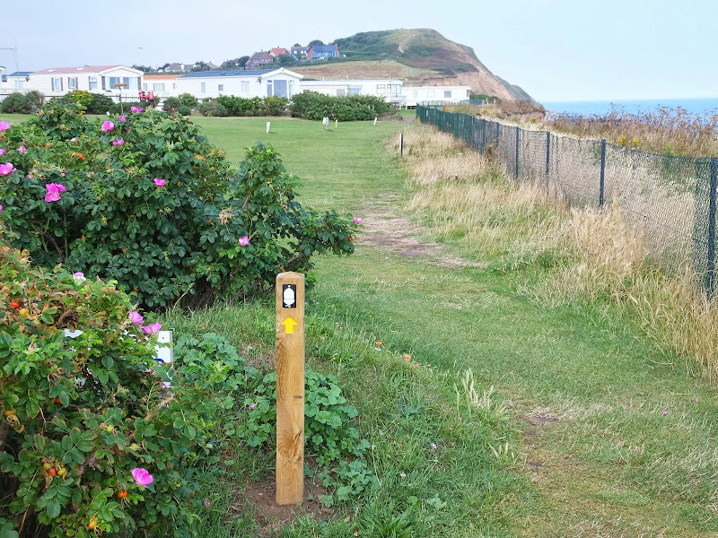
The Norfolk Coast Path extension is well defined throughout with the usual acorn symbol waymarkers that typify a national trail
Beeston to Cromer
This section follows the original route over Beeston Bump although new steps and hand rails have been implemented for this climb. Beyond this the new route uses the old permissive paths in front of Beeston Campsite and along the clifftop, past the beach road at West Runton and on to Woodhill Park campsite. It then follows the western and southern perimeter of the campsite before exiting onto the pavement to continue into East Runton village. As the road leaves East Runton there is a track on the left between two caravan sites. The path follows this for several hundred yards before returning to the road via a footpath on the right. There is a short distance along the pavement past a terrace of cottages and the Wyndham Caravan Park before it cuts across a grassed area to the clifftop where it continues down into Cromer. There is currently no additional marker on the waymarker post in front of the pier. However the path does continue onwards along the promenade towards Happy Valley.
Cromer to Overstrand
The path proceeds along the prom and then up to the path that leads along the cliff tops to Happy Valley. Opposite an octagonal shelter is a waymarker pointing down the cliffs via a set of steps. The path then continues along the beach to Overstrand following the route of the Paston Way. It is unknown why negotiation with the golf club to use the permissive path beyond the Cromer Lighthouse was not undertaken as this would have been a much more favourable route with some spectacular views. The beach route is accessible during most states of tide but given an unusually high tide the route will be unpassable and this permissive path can act as a viable alternative route through to Overstrand.
Overstrand to Trimingham
The path follows Overstrand Prom until its end where it then ascends the steep roadway into the Eastern end of the village. This leads out onto the main coast road where there is a pavement through to a track just beyond Manor Farm. This leads up to an old permissive footpath along the cliff tops through to Trimmingham.
Trimingham to Mundesley
The route follows the coast road out of Trimingham. After a couple of field boundaries, a country lane bears off to the right. The signage here is a little poor as there is no clear indication that this lane should be taken but this is most certainly the correct route. Proceeding along the coast road is hazardous as there is no verge or pavement throughout the double bends in front of the radar station. Not far down the lane there is footpath on the right that leads around the back of the radar station and back to the main coast road. From here a high verge has been trimmed down to allow walking access alongside the road through to a junction with another lane. Opposite this junction is the entrance to the Trimingham House Holiday Park where a Coast Path waymarker directs down the entrance road. Continue on the access road, beyond the barrier and follow the road through the holiday park. At the far end another waymarker confirms that this is the correct route. The path continues along the cliff top, crosses a beach road to continue along the cliffs, in front of another holiday park. Eventually the way ahead is barred by a low wooden fence, but a path leads into the holiday park and then out to the main Coast Road where finger posts once again confirm this is the correct route. Follow the road down into Mundesley village where a waymarker then directs down to the prom adjacent to the Mundesley Maritime Museum.
Mundesley to Bacton
This is a beach walk following the route of the Paston Way. This can be blocked at the Bacton end by high tides, therefore tide times need to be consulted. The adoption of this route appears to have been taken as the making a public right of way from the permissive path that runs along the clifftops in front of the Bacton Gas Terminal is deemed a security risk for the site. Nonetheless if the tide is not right then the permissive path can be a viable alternative. This can be found by following the road out of Mundesley and just past the sharp turn inland take the left hand lane and follow this to its end where it leads into a path along the cliff tops through to Bacton.
Bacton to Happisburgh
This follows the concrete defences in front of Walcott then negotiates its way thorough Bush Estate at Ostend to the clifftop path to Happisburgh
Happisburgh to Sea Palling
The route continues along the cliff top path to Eccles and then follows Doggetts Lane behind the chalets to Cart Gap where the beach is followed to Sea Palling. An alternative route here is the track that is on the landward side of the dunes.
Summary of Document Changes
Last Updated: 2021-12-07


0 comments:
Post a Comment