Bromeswell Village Walk
|
Tuesday 17 December 2019
|
No comments |
![]()
A very easy 2 mile walk around the Suffolk Village of Bromeswell
The Sandlings Path avoids the busy road between Melton and the footpath across the Heathland to Rendlesham Forest by navigating around the quiet village of Bromeswell. Although only a short distance, it is worth taking ones time to explore this quiet village with its typically East Anglian church of St Edmund.
The Sandlings Walk - Bromeswell Village Walk - Essential Information
Walk Statistics:
- Start location: Bromeswell Turn
- End location: Melton
- Distance: miles ( km)
- Total Gain: ft ( metre)
- Total Descent: ft ( metre)
- Min Height: ft ( metre)
- Max Height: ft ( metre)
- Walk Time:
- Walk type: Linear
- Walk Grade: Easy
- Terrain:
Maps:
The following maps and services can assist in navigating this route. There are links to printed maps and links to downloadable GPX route data for importing into navigational software and apps.
- Ordnance Survey Explorer Map
- OS Explorer 212 - Woodbridge & Saxmundham
- GPX Route File
Transport:
Details of public transport that is required for the walk
First Group - Bus Service
- Service Details
- 800 - First Group 800 Service linking Ipswich, Woodbridge, Melton and Rendlesham.
- Timetable
- Suffolk On Board Website
Route Verification Details
- Date of Walk: 2012-11-17
- Walk Time: 10:30 to 11:30
- Walkers: Griffmonster
- Weather Conditions: Overcast with light rain showers
Walk Notes
The Sandlings Path, along with the Suffolk Coast Path are probably my most walked long distance paths. Living in the area means that most sections get walked multiple times throughout the year. However, despite this, until this walk I had never wandered around the short section through Bromeswell. There may be a couple of reasons for this, firstly the river walk from Melton through to Woodbridge does not lend itself to extend across the bridge and up to Bromeswell, which would be going out of ones way. Secondly the section through Rendlesham Forest starts at the bus stop on the opposite side of Bromeswell leaving the village as just a short lane linking these two sections.
Looking at the OS map the official path appears to go out of its way just to go into the village but this is intentional as the direct route along the B1084 is definitely not advisable. This road is a very busy highway without any pathway, presenting a clear hazard to walkers. Therefore the quiet single track lanes through Bromeswell are a natural choice and if you venture up these you will not be disappointed by this typical Suffolk Village.
This particular occasion was a Saturday in late Autumn and with a planned visit to Ipswich Hospital scheduled for 3pm it left a few spare hours to find something worthy to occupy the time. Therefore, not having the time for a full scale day walk a day ticket on Anglian Buses was purchased with which I could explore the route of the 165 service between Leiston and Ipswich which runs the general route of the Sandlings long distance path.
Unfortunately this part of Suffolk has seen a succession of cutbacks to public transport making shorter sections of the Sandlings trail somewhat difficult to achieve. The 165 service was one of the first cutbacks, and this was not down to profitability but due to Anglian buses being taken over by the national company GoAhead which maintains a higher level of profit to consider a service viable. One has to question who benefits from this, which certainly appears to be large corporate concerns and definitely not the general public. Despite First Group instating a replacement service, this was short lived and has also been discontinued. The only present (winter 2017) services for this part of the world are the First Group 800 service between Woodbridge and Rendlesham and the 64 service which connects Leiston and Woodbridge. Therefore this walk is still achievable using the 800 service from Melton.
There is a bus stop at Bromeswell turn by the junction with the Orford/Rendlesham roads,from where one can walk into the village and then return to Melton where there is a bus stop at the railway station. From here, dependant upon the remaining time, I could continue a walk at any point onwards knowing the the Sandlings Path ended at the hospital. There cant be many hospitals that have a long distance path at their entrance!.
Included in this walk is the Wilford Bridge pub which is just over the bridge across the Deben. Unfortunately it was not open by the time I arrived, Rather than waiting half an hour for the pub to open and with the bus arrival imminent it seemed pertinent to continue my journey and stop for refreshments further along the route.

Directions
A simple walk following the lane into Bromeswell then out to Melton
There is a bus stop at the Bromeswell turn, just beyond the junction with the Eyke and Orford roads from where the Sandlings waymarker directs one up the lane on the north side of the road. Follow this lane into the village and the Church can be found along Church Lane on the right. Continue along the road through the village until there is a junction centred with a triangle of grass. Turn right and follow the lane out of the village.
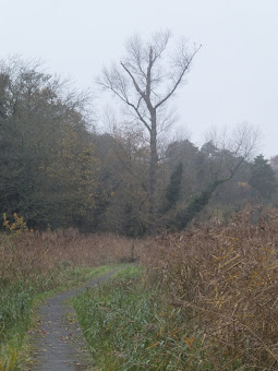
As the lane approaches the Melton road look out for a waymarker on the right which leads onto boardwalks. Keep to this until there is access up to the road. Cross the river bridge, cross the road and follow the path alongside the river bank. Keep to this until the river bends around to the left. At this point there is access down to the car park. Walk out of the car park, turn left and cross the railway line. Melton Station is located on the left and the bus stop is adjacent.
Pubs
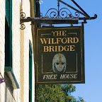
The Wilford Bridge, Melton View in OS Map | View in Google Map
- Address
- Melton Road, Melton
- Website
- www.debeninns.co.uk/wilfordbridge/
Prior to being known as The Wilford Bridge, this pub was known as the Railway Tavern, a name that dates from the building of the East Suffolk Railway Line between Ipswich and Great Yarmouth in 1859. Records show that the pub predates this but there is no indication as to what it was known as prior to the coming of the railway.
Currently owned by the Deben Inns group, this well presented establishment offers restaurant food, a patio area and cask ale
Did not visit on this occasion

Features
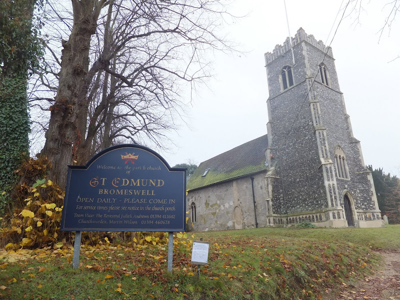
St Edmunds ChurchView in OS Map | View in Google Map
It is thought that a church has occupied the present site in Bromeswell since Saxon times. This would most likely have been a structure of wattle and daub or wood. The Normans rebuilt the church and there is evidence from this era with the 11th century slit window in the north wall of the nave and a 12th century south doorway. The rest of the building dates from other eras with the tower and nave being constructed in the 15th century, the south porch in the 16th century and the chancel in the nineteenth century when the whole church was altered.
The north side of the church, which faces the road, is curious in the fact that it has few windows and a bricked up door given the appearance of a blank wall. A path leads around to the south entrance. According to Simon Knotts Church Website the modern vestry was built on ground that had a number of burials. As this was the north side of the church it was assumed that the unearthed skeletons were those of either suicides or the unbaptized and as such they were reburied without ceremony.
The most striking sight on entering the church are the angelic figures clutching shields that protrude from the roof timbers. The two at the east end of the church are wooden carvings whereas the rest are fibreglass copies. The two original ones were carved in the 1920's by the vicar of Eyke, the Reverend Darling. The intention was to mount them in Rendlesham church but they turned out to be the wrong size and were donated to St Edmunds.
At the west end of the church, there are holes the size of a fist on opposing walls. These extend into the wall, though not through it. IT is not known what these were used for and they appear too low down to be for a supporting beam for a floor.
The tower originally contained three bells, but the smallest fell down and broke and was sold. Of the remaining bells, the smallest is known as the Mechlin Bell having been cast by the Mechlin foundry in Belgium. The bell is decorated with two scenes of rosary mysteries, the Annunciation and the Presentation, as well as the flight into Egypt, and St Michael confronting a dragon. On it, in old Flemish, is written Jesus am I, cast by Cornelis Waghevens in the year of Our Lord 1530. Illustrations can be found in Church Bells of Suffolk, an 1890 publication by John James Raven.

Gallery
Below are a selection of images taken from from the photo album for this walk. Feel free to browse through these or click on an image to view a larger version in the Gallery.


Summary of Document Changes
Last Updated: 2021-12-07


0 comments:
Post a Comment