South West Coast Path - Porthleven to The Lizard
|
Sunday 23 December 2018
|
No comments |
![]()
An 15 mile walk along the Cornish section of the South West Coast Path between Porthleven and The Lizard
A walk to Britain's most southerly point, The Lizard. There are a few challenging climbs along the route although the path is predominantly across grassy cliff-tops with some fantastic views along the coast. This walk crosses the renowned Loe Bar in front of Loe Pool which is said to have been where King Arthur's sword Excalibur was thrown upon his death.
Porthleven to Lizard Village Walk - Essential Information
Walk Statistics:
- Start location: Porthleven
- End location: Lizard Village
- Distance: miles ( km)
- Total Gain: ft ( metre)
- Total Descent: ft ( metre)
- Min Height: ft ( metre)
- Max Height: ft ( metre)
- Walk Time:
- Walk type: Linear
- Walk Grade: Not too strenuous, a few climbs
- Terrain:
Maps:
The following maps and services can assist in navigating this route. There are links to printed maps and links to downloadable GPX route data for importing into navigational software and apps.
- Ordnance Survey Explorer Map
- OS Explorer 103 - The Lizard
- GPX Route File
Accommodation:
Mill Lane Camping and Caravan Park, PorthlevenView in OS Map | View in Google Map
- Website
- https://www.facebook.com/MillLaneCampsite/
- Description
- Mill Lane Camping and Caravan Park, Mill lane, Porthleven, Cornwall TR13 9LQ
Transport:
Details of public transport that is required for the walk
Bus Service
- Service Details
- At the time of walking this route the local 2 bus service was provided by First Kernow and linked Penzance, Helston, Falmouth and Truro. Due to the ever changing landscape of public transport it is advised to use the Traveline website to get the latest timetables and operators
- Timetable
- Traveline Website
First Group - Bus Service
- Service Details
- 37/34 - At the time of walking this route the local 37/34 bus service was provided by First Kernow and linked Helston and The Lizard. Due to the ever changing landscape of public transport it is advised to use the Traveline website to get the latest timetables and operators.
- Timetable
- Traveline Website
Route Verification Details
- Date of Walk: 2012-07-01
- Walk Time: 07:30 to 13:30
- Walkers: Griffmonster, Kat
- Weather Conditions: Sunny and warm with cloud bubbling up as the day went on
Walk Notes
This was the eighth day of a two week walking expedition along South Cornwall section of the South West Coast Path.
Choosing the walk for the day
As this expedition along the South West Coast Path was being undertaken as a sectional walk using base-camps and public transport, the direction of travel and the daily sections to walk was dictated by the availability of the local bus services. Being a Sunday, only a few bus services run which means that the sections from Helford to Coverack and Coverack to The Lizard were inaccessible and had to be left for a weekday. The next section along the route is The Lizard to Porthleven, but to give the optimum amount of time to achieve the distance it is beneficial to walk this in the opposite direction from where there are buses back into Helston. I have to admit that ending at The Lizard is a worthy climax to a days walk.
The day started as a fine English summers morning with blue sky and plenty of sunshine. Early morning on a Sunday is such a glorious time to wander through any town or village as it is one of the few times that one can truly appreciate the place without the hustle and bustle of everyday life. Porthleven was just that. A picturesque little Cornish fishing village with an inner and outer harbour. Not a soul about. Tranquil in the morning sunshine, the tide out, leaving numerous little fishing boats beached on the sand of the harbour. Two canons stand on guard on either side of the entrance to the inner harbour. The church tower stands ominously at the head of the harbour looking striking against the deep blue sky.
Churches and Museums
The walking is easy to begin with, over the cliffs to Loe Bar, then across the shingle and over the next stretch of cliffs. Eventually the path leads down to the curious cove known as Church Cove where there is a Church with a detached bell tower built into the surrounding rock. The church is dedicated to St Winwaloe, a little known sixth century saint who was born in Brittany to Cornish parents. The building dates from the 13th Century though there has been a place of worship on the site from the 6th century.
Beyond the church the path crosses the sandy cove where a stream runs down the beach, spreading out in delta fashion as it trickles down to the sea. A makeshift dam sits at the head of the beach made from piles of pebbles and stones, ineffective in holding back the waters but presenting a method to cross the water course without getting ones feet wet. A simple procedure of balancing and pivoting across the stones resulted in a little bit of challenging fun with the chance of missing a footing or treading on a loose pebble and falling in the shallow waters. Kat took the easy approach and hopped and jumped across the many streamlets that the stream fan-tailed out into at the bottom of the beach.
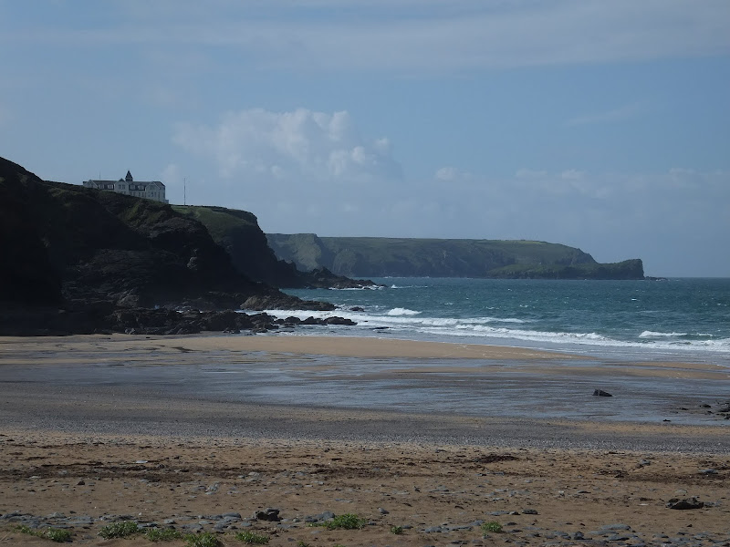
The walking becomes a little more strenuous as the path navigates up and over the cliffs to Poldu Cove where there is the former Marconi radar station, which is now a museum, and a little further on a monument dedicated to Marconi's work. The path then drops down to Polurrian Cove which is the closest it gets to the village of Mullion, a mile inland. Across another cliff-top and the path once again drops to the next cove, Mullion Cove, a little fishing hamlet with a pretty harbour that dates from 1895. Here we found a cafe which was just opening up for business and took time out for a pot of tea and flapjacks and to reflect on the scenes we had witnessed along the route thus far.
The easy way and the hard way to get down to Kynance Cove
Past Rill Point and the cairn known as Apron String the route heads to Kynance Cove. The broad grassy downs on this section have numerous worn tracks where people have trampled over the years and it is not clear what is the official route. On a day such as the glorious Sunday that we were treading our way southwards, there were many people about and it was easy to follow those ahead. In this case, a couple of ladies could be seen some distance in front of us, casually strolling as we slowly caught up with them. The cove lay ahead behind a craggy formation atop the cliff. With the multiple tracks I made a brief consultation with the OS map but this did not offer much of a revelation it only marked the coast path and a route up the valley from the cover. The figures ahead disappeared from view beyond the crag and we headed towards where they were last seen, arriving at the scene to be confronted with these two middle-aged ladies attempting to clamber down a 12 foot near vertical drop of cliff face. One had managed to get herself down and was guiding the second lady. They seemed totally unperturbed by the difficulty this was causing. We gazed on with nervous hesitation as this did not seem right that the coast path should have such a treacherous way to get down to the Cove. I retraced my steps to see if there was any other obvious path but the only other route appeared to be the one that led inland. After several minutes the two ladies had successfully scaled the cliff and I called down to them to ask if this was the correct route in the hope that they knew the area. They were tourists themselves and assumed it must be the coast path as they had seen no other way down. More dubious hesitancy. I called out to the two ladies to be certain that the path continued down to the Cove. I didn't fancy trying to get back up if it led nowhere. They assured us that there was a pathway beyond. I sheepishly edged to the drop and carefully started lowering myself down. There were enough crags on the granite that could be used to step down though it wasn't the easiest of tasks. I do suffer from vertigo but just concentrated on the task in hand and was soon at the base. It did make me wonder how anyone could actually get back up. At least in going down there was the assistance of gravity but going up there was little to assist in leveraging and pulling oneself upwards. It was an effort, but with a little care and time both me and Kat managed to get down. Not frightening but certainly not the thing one expects on the coast path.
The followed the worn track out alongside the crag and onto a flat grassy area atop the cliffs where groups of people stood admiring the scenery. To the left was a trusty coast path waymarker pointing down some craggy stepped stones which zig-zagged to the cove. The other side of the post pointed across the grassy area rather than the route we had just come down. We had taken the wrong route. Looking at where it was pointing revealed several groups of walkers ambling up alongside the cliff edge. The official route hugged the cliff edge and this is where we had gone wrong, taking the broader track which appeared the obvious. Such an easy mistake.
Once on the other side and looking back across the cover we noticed a young chap surveying the same incorrect descent we had negotiated. It appeared that he was having the the same hesitation about the way ahead that we had. Eventually he started lowering himself down. It would appear that this was a common misdirection. Maybe a better waymarker for walkers heading south may resolve this.
The Lizard
It was something of a fulfilment to reach such a renowned endpoint as the Lizard. The sense that a walk was completed, the sense of achievement. The furthest one can walk south in Britain and we were there. No fanfare. No razzmatazz. No accolade. No spectacular monument. Just the rock, the grass, the breeze, the sound of the sea crashing against the rocks and the sense of being somewhere significant. Whether one has walked the 15 miles, 150 miles or 1500 miles it is a sense of completion with only ones own knowledge that the distance is complete. There should be no more than that. A simple plaque declares 'The Lizard' and a small National Trust marker states 'Old Lizard Head'. Thats all one needs to know. Simple. Natural. The way it should be. A group of youngsters sat on the grass atop the highest point of the cliff gazing out at sea. Had they arrived after a journey or were they just day-trippers who had toddled up from the road and wondering what the fuss is about? It didn't matter. Their silhouettes against the blue sky said it all.
After a few moments pause to reflect on the wonders of the natural beauty, we headed off to get onto the lane up to Lizard village. With the lifeboat house and slipway in sight, we passed a group of youths being herded down to the Lizard. About 20 teenage girls and boys who did not seem overawed by the landscape or the prospect of having to walk the coast path to get a view of this so called Lizard. They sluggishly drew up to where one of the leaders had stopped to dish out a few words of advise. A girl spoke up, stating that she was in need of the loo and without any time for an answer she descended to a grassy ledge out of sight of the group, though in full view of the path leading from the lifeboat house, crowded with people. Kids! We were all like that once! Well maybe, I have fond recollections of being led up the mountains of the lake district when I was their age. That was overwhelming. They will learn.
The single track lane down to the lifeboat house was busy with frequent cars heading to a small car park. It made me wonder why people could not just walk down to this point, there was a good well drained path away from the road which led most of the distance from the village to the coast path. On reaching the village of Lizard there were more cars. A sea of motors brashly parked across the village green. Is this what our treasured villages were becoming, nothing more than car parks? Such a shame. After a drink at the Witches Ball we stood alongside the green and waited for the bus to Helston along with a few other people. We watched the scene as more tourists drove into the village. Faces staring from the confines of a car. I'm sorry, but that doesn't appeal to me. You cant admire views from a car. You need to stand in the view. Be part of it. Experience it. More and more tourists arrived in their metal boxes. Carving up the edge of the green as they attempted to deposit their cars so they could spend time wandering around the myriad tourist shops full of mantelpiece clutter. Then armed with their mementos, off they would go. Another location to tick off on their itinerary list of places to visit. IF there was ever a piece of advise to any of them it would be leave your car at home and experience reality. But hey, who am I to judge. Though, I do know we walked to Lizard Point and was rewarded with the beauty of the rock and the grass, the sound of the sea and the sense of achievement and that is pure satisfaction itself.

Directions
Follow the well marked South West Coast Path trail which is marked with the usual National Trail Acorn waymarkers.
The walk uses the official route throughout the entire distance from Porthleven to the Lizard. Take the southerly side of Porhleven harbour and follow this down to the church tower. Keep to the road following the coast until there is a path that leads to Loe Bar.
There is little ambiguity from this point as long as one follows the waymarkers which are frequently posted. There is confusion as the path approaches Kynance Cove and the official route keeps close to the cliff edge. Ignore the wide path that heads to the crag as this results in a 12 foot climb down the rocks.
Once again, beyond Kynance Cove the path is simple to follow all the way through to Lizard Point. From here continue as the coast turns eastwards up to the road where the lifeboat station is located. Walk up this road until there is a path on the left which runs parallel to the road all the way into Lizard village. Continue straight through the village and at its northerly end is the village green where the bus service to Helston departs from.

Pubs
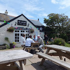
The Witch Ball, Lizard View in OS Map | View in Google Map
- Address
- The Witch Ball, Lizard
- Website
- www.witchball.co.uk/
Although the building dates from the 1400's, it has only been uses as a pub and restaurant for the last 50 years. Before this time it was a farm. The pub is said to be haunted by the ghost of a stable lad by the name of George who was killed when a horse kicked him in the head in 1710. He is reputed to move things around. Another ghost of a soldier named Ferdinand is also said to haunt the bar. He was said to be a soldier who was washed up on the shore from a Spanish invasion fleet which foundered in a storm in October 1597.
The name of the pub is taken from the hollow spheres of plain or stained glass hung in cottage windows in 18th century England to ward off evil spirits which were known as Witch Balls. It is said that if a visitors reflection could not be seen in the ball then that person was either a witch or was possessed by evil spirits and should not be allowed across the threshold. The pub has an example of such an artifact which hangs in the restaurant window and dates from 1721.
Beer is supplied by the local Cornish Chough brewery as well as Skinners of Truro and St Austells. A simple but mouth watering menu uses locally caught crab and lobster. locally sourced meat and even the bread is baked at Fat Jacks next door.
It was so good to find a pub that offered ales other than St Austells. I have nothing against St Austells and their ales are excellent but when one knows there are other local brews then its so refreshing to actually find them. The Witch Ball had four ales on offer including The Cornish Choughs Lizard Storm which was an amber bitter with a light dry palate and a slight hint of citrus. This was followed by a Ginger Tosser from Skinners Brewery. There is something childishly satisfying in going up to a bar and declaring in a firm stout voice, 'I would like a Ginger Tosser please'. Unfortunately the barmaid did not comprehend the humour. She did not comprehend most things spoken in English and struggled to understand orders and was totally confused when it came to changing a barrel. Poor girl! The place was busy with diners and there was soon a queue for beer caused by an ale running out. A little patience resolved the issue and the Ginger Tosser was a golden hoppy ale with just a hint of ginger to it. Certainly not in your face. Very drinkable.
Features
The Legends and Myths of Loe BarView in OS Map | View in Google Map
Jan Tregeagle
If one walks southwards along the coast from Porthleven they will soon find themselves trudging across the shingle at Loe Bar which separates the sea from the natural freshwater lake known as Loe Pool, part of the old estuary to the River Cober which, it is said, enabled ships to sail up to Helston. Walking on shingle is an almost a Sisyphean task at times, where one step forward seems to be accompanied half a step back. Fortunately this is just a short length of beach walking though it does allow some enlightenment to the misfortunes that came to the departed spirit of one Jan Tregeagle.
In life, Jan Tregeagle was an evil man whose wrong doings and wicked ways amassed him a great deal of wealth. It was said that there was not a single sin that he had not committed in order to add to his gains. But as his life wore on and feeling remorse for his dreadful deeds, and no doubt fearful of his own judgement in the afterlife, he donated vast sums of money to the church in exchange that the clergy would petition for his soul to be saved from the fires of hell and all of its demons. It wasn't long before he passed away, and the priests kept their side of the bargain by undertaking constant vigil of reciting prayers for his departed soul.
This worked, until, one day in a court case the defendant requested to summon up the spirit of Jan Tregeagle in order to prove his innocence. The judge surprisingly agreed and the ghostly haggered figure took his place in court and, with the judge unperturbed by the shocking sight, he was allowed to give evidence. However, being returned to this earthly plain allowed Tregeagle's spirit to be at the mercy of the demons that sought to drag his soul to the fiery pit. To prevent this, the priests decided that as long as he was kept busy until the final day of judgement then the demons would not bother him. For this they needed a timeless task and after much discussion and thought they requested him to empty out the bottomless Dozmary Pool, which is found high on Bodmin Moor. To make the task more difficult he was made to empty the pool with a limpet shell... and the shell had a hole in it. Tregeagle set about the task and worked tirelessly day and night, week after week. Nothing stopped him until a storm blew up that was so ferocious that he was forced to seek shelter, just for a brief moment. But a brief moment that was all it took for the demons to pounce. Luckily, Tregeagle managed to leap across the pool and escape their clutches. He ran all the way to the hermitage on Roche Rocks near St Austell where he sought sanctuary. In his haste to get away he managed to get stuck whilst trying to climb through a window leaving his bottom facing both the elements of the storm and the howling demons.
The holy man of the hermitage, not wanting to have a rogue spirit's bottom hanging out of his window, summoned the priests to deal with the situation. They hastily arrived at the hermitage and managed to free Tregeagle from his wedged position. Another task was called for to keep Tregeagle busy and this time it was to weave a truss of sand and spin a sand rope to bind it with. An impossible task but nonetheless Tregeagle set about it with diligence, spending day and night, week after week attempting to craft the sand into a truss. However, yet another storm soon blew up and completely destroyed his work and once again he had to flee from the clutches of the demons and seek sanctuary.
This time St Petroc himself intervened to set Tregeagle a task. Binding him in chains, he was assigned the burden of carrying all the sand from the beach below Berepper across the estuary of the River Cober and over to Porthleven. This was a futile task since the sand that was placed at Porthleven was then returned to its original place by the tide. No matter how big the sacks of sand carried by Tregeagle, they could not defeat the tide. Even so, he toiled day and night, week after week carrying sacks of sand northwards and trudging back with his empty sack for more. All this time the demons watched and waited for a chance to ensnare Tregeagle and carry him off. So impatient the demons became that eventually one of them tripped Jan Tregeagle up as he crossed the estuary, sack of sand on his back. He fell flat on his face and the hefty sack split as it was tossed to the ground with the sand spilling out asunder. Such was the size of the sack that the sand flowed right across the estuary, blocking up the stream, and separating the waters from the sea. Thus it was that Loe Bar was formed and the lake soon formed behind the dam and it is still there today.
So what became of old Jan Tregeagle? Well, it is said that a final task was set for him and one which he still toils over to this very day. Every day, every month, every year he continues to sweep the sand from Porthcurno Cove near Lands End round to Mill Bay. Locals will tell you that on dark stormy nights you can hear Jan Tregeagle moaning and howling as he attempts to complete his hopeless task. Some say you can hear him all over Cornwall wailing away as he toils incessantly on.
The legend of King Arthur and Excalibur
The lake behind Low Bar is locally known as Loe Pool and this is said to be the very lake that King Arthur had his sword Excalibur tossed in his last moments before death.
King Arthur, having been mortally wounded in battle and knowing death would soon take its place, gave instruction to his favourite knight, Sir Bedivere, to take his sword Excalibur and cast it into the lake at Loe Pool. At first, Sir Bedivere thinking the sword to be too valuable an item to willfully cast away, hid it and returned to Arthur stating that the deed had been done. Arthur, suspecting this not to be the case, asked Sir Bedivere what had happened after he cast the sword to which the knight could offer nothing of interest. Once again Arthur instructed Sir Bedivere to return and throw the sword into the lake without any concern to its value. This time Sir Bedivere took the sword and cast it out to the centre of the lake. As it swirled through the air, a hand rose from the waters and caught the sword in flight before slowly sinking back into the depths.
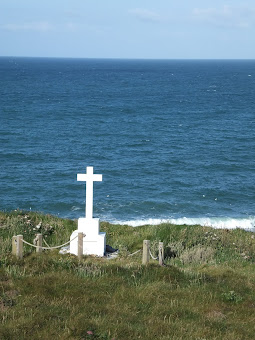
HMS Anson Monument, CornwallView in OS Map | View in Google Map
The HMS Anson Monument is a white cross located on high ground overlooking Loe Bar and Porthleven Sands to commemorate the lives of 'about 100 officers and men of HMS Anson who were drowned in 1807. A plaque reads 'Sacred to the memory of about 100 officers and men of HMS Anson who were drowned when the ship was wrecked on Loe Bar 29th Dec. 1807. And buried hereabout Henry Trengrouse of Helston was so impressed by this tragedy that he invented the life saving rocket apparatus which has since been instrumental in saving thousands of lives. Erected march 1949'
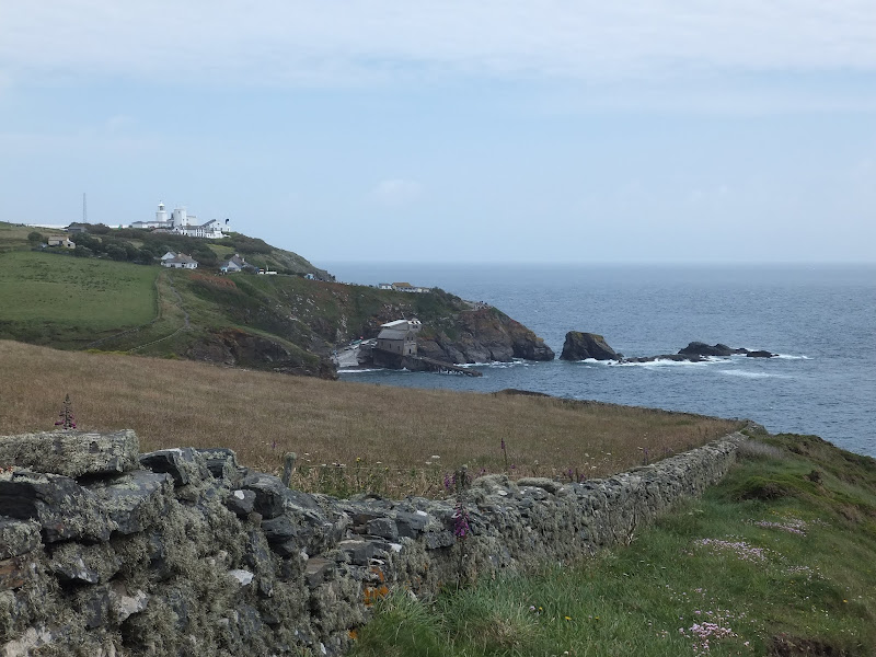
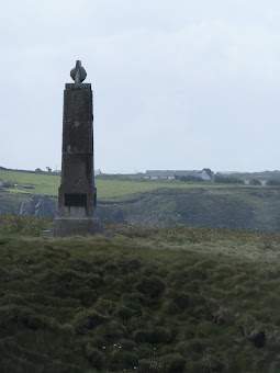
Marconi MemorialView in OS Map | View in Google Map
On the cliffs beyond Poldhu Cove is a memorial consisting of a square base on which is a slightly tapered shaft surmounted by the emblem of a globe within a double triangular frame. Four plaques are mounted on each side of the plinth to commemorate the work of Guglielmo Marconi and his experiments at the Poldhu Wireless Station between 1900 and 1933. It was from the wireless station that the first signals to be wirelessly transmitted across the Atlantic on September 12 1901. The memorial was erected in 1937
The legend of Apron StringView in OS Map | View in Google Map
On the southern side of the Mullion Cove the path steeply climbs to the Lizard National Nature Reserve presenting a wide and fairly flat grassy area and the going becomes easy as the path navigates across to Lower Predannack Downs and Kynance Cove. At Rill Point the direction of the cliffs and path turn from due south to due west and it is here that one finds a small Cairn of rough stones locally known as the Apron String. They were said to have been put there by an evil spirit who intended to use them to build a bridge across to France for the convenience of smugglers. The spirit carried the stones in an apron but as he got to the cliff edge the apron strings broke and the stones fell to form the cairn. The evil spirit then gave up the idea of building a bridge!
Gallery
Below are a selection of images taken from from the photo album for this walk. Feel free to browse through these or click on an image to view a larger version in the Gallery.


Summary of Document Changes
Last Updated: 2021-12-07
Coast Walk, Cornwall, Distance:long, Features:Folklore, Features:Local History, full-detail, OSmap:103, South West Coast Path


0 comments:
Post a Comment