South West Coast Path - Marazion to Porthleven
|
Sunday 30 December 2018
|
No comments |
![]()
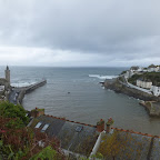
An 11 mile walk along the Cornish section of the South West Coast Path between Marazion and Porthleven
A moderate section of coast walking with few strenuous challenges as the path negotiates the cliffs from Marazion to Porthleven. With disused tin mines, the surfing beach at Praa Sands and the charming buildings around Prussia Cove there's plenty to take in along the way.
Marazion to Porthleven Walk - Essential Information
Walk Statistics:
- Start location: Marazion
- End location: Porthleven
- Distance: miles ( km)
- Total Gain: ft ( metre)
- Total Descent: ft ( metre)
- Min Height: ft ( metre)
- Max Height: ft ( metre)
- Walk Time:
- Walk type: Linear
- Walk Grade: A few challenging climbs
- Terrain:
Maps:
The following maps and services can assist in navigating this route. There are links to printed maps and links to downloadable GPX route data for importing into navigational software and apps.
- Ordnance Survey Explorer Map
- OS Explorer 102 - Land's End
- GPX Route File
Accommodation:
Mill Lane Camping and Caravan Park, PorthlevenView in OS Map | View in Google Map
- Website
- https://www.facebook.com/MillLaneCampsite/
- Description
- Mill Lane Camping and Caravan Park, Mill lane, Porthleven, Cornwall TR13 9LQ
Transport:
Details of public transport that is required for the walk
Bus Service
- Service Details
- At the time of walking this route the local 2 bus service was provided by First Kernow and linked Penzance, Helston, Falmouth and Truro. Due to the ever changing landscape of public transport it is advised to use the Traveline website to get the latest timetables and operators
- Timetable
- Traveline Website
Route Verification Details
- Date of Walk: 2012-07-04
- Walk Time: 15:00 to 20:00
- Walkers: Griffmonster, Kat
- Weather Conditions: Persistent rain before the walk with ever brightening skies.
Walk Notes
This was the 11th day of a two week walking expedition along South Cornwall section of the South West Coast Path using a base-camp at Porthleven and public transport to get to and from each days walk.
This turned out to be the last full days walk of the expedition along the southern Cornish Coast. It was not meant to have been that way but the weather turned against us once again and with an impending storm forecast for the Friday evening we had decided to leave the county a day early. This was a good decision judging by the scenes witnessed on national news programmes once we returned home.
In the full two weeks of walking we had not achieved our aim which was to walk from Plymouth to Lands End. This is probably the first walking expedition that I have not completed the expected distance. The ultimate reason for this was the weather. We had storms, gale force winds, pea-soup fog and persistent and torrential rain. In general I don't mind what the weather may throw in my direction and have walked through the worse of all weathers on previous walks but ultimately safety had to be considered on these unknown paths that navigate around the cliffs. Through both Dorset and Devon we had kept to our targets despite rain and fog but this year the weather had been considerably worse. In all it was the worse summer weather I had experienced for a very long time.
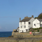
Looking on the bright side, when things do not go to plan, then it provides the potential for future endeavours. A return would be planned for the following summer to continue of the expedition, to fill in the gaps that were missed on this year, to complete the sections from Helford to the Lizard and from Mousehole to Lands End and then to go beyond to the north side of the county. There is a consolation here in the fact that Porthleven was a place that we wanted to return to and would became one of our favourite places to stay along the whole South West Coast Path. Although so many other picture postcard villages looked ideal, Porthleven gained the upper-hand when it came to planning sectional walks. It had plenty of facilities, several pubs and restaurants, the campsite was close to the village and there was a regular bus service with ample connections to other services further afield. A perfect base and a typical Cornish village nestled in a cove between the cliffs with an inner and outer harbour and its iconic church on the harbour front which has been depicted in so many a photograph, video and picture postcard, especially when a storm lashes the coast and the tempestuous waves clear the church tower.
This particular days walk very nearly did not happen. The day started dull with a heavy blanket of grey cloud giving persistent rain from the moment dawn beckoned. The weather forecast held little promise for the rest of the day. Not to be disappointed we decided to spend the day on the buses using the 3-day rover ticket we had purchased to get us to and from the days walks. At least this would give a view of some of the villages that we will inevitable walk through on future visits. The First Group buses enabled us to get to Penzance from where an open top bus went onto Lands End. By this time, luckily, the rain had turned to intermittent drizzle. Then for a brief hour there was clear blue skies and sunshine as we took a short walk from Lands End to Sennan Cove. This is only a mile or so but at least it was something salvaged from the day. The open top bus returned back through St Ives and across to Marazion, arriving there at lunch-time. The weather was now brightening up and a brisk breeze was drying things out.
On old 19th century maps the town of Marazion is accompanied by an alternative name of Market Jew which is derived from the Cornish language Marghas Yow, meaning Thursday Market. The Coast Path uses the road through the town with a simple diversion across to St Micheal's Mount which is well worth taking the time out to explore. The causeway is tidal so walking this has to be timed right otherwise the ferry is required for the crossing. On this occasion it was low tide on arrival so an hour was taken to stroll across to the Mount and look around. This has been both a fortress and a Benedictine monastery in its time but these days it is managed by the National Trust. One could easily spend a lot more time exploring the Castle and Gardens but with the brightening skies the decision was made to tentatively attempt the coast path through to Porthleven.
It is an 11 mile trek following the coastline to Porthleven although the terrain is generally not too strenuous and such a ramble should easily be accomplished given a full afternoon and early evening. There are also plenty of access paths, tracks and lanes back to the main road if the going becomes too dangerous and one needs to curtail the walk. In the event, although there were a few quagmires of boggy mud to negotiate, on the whole the going was none too bad.
The cliff paths are accessed via a track on the eastern side of Marazion and this leads down to the beach for several yards before there is a clamber onto the low level cliff top. It is then easy walking down to Prussia Cove. The headland takes a little more effort to get around and one is rewarded with the architecture of the houses at Porth En Alls which these days are holiday accommodation and wedding venues.
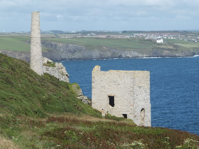
More cliff top walking leads the trekker down to Praa Sands, a large sandy beach that is popular with surfers. The path leads out from the village, across heathland and back to cliff top paths. This section is characterised by old tin mine workings, so typical of the Cornish landscape. In all this was a pleasing walk and by the time we emerged into Porthleven the sun was shining and blues skies complimented a good end to the days walk and indeed the whole of the two week expedition.

Directions
Follow the well marked South West Coast Path trail which is marked with the usual National Trail Acorn waymarkers.
The path can be found on the east side of Marazion, by a cemetery. It descends down to a little beach from where theres a clamber back up the cliffs. From here on it is just a case of following the way markers all the way through to Porthleven.

Pubs
The Kings Arms, Marazion View in OS Map | View in Google Map
- Address
- The Kings Arms, Marazion
- Website
- www.kingsarmsmarazion.co.uk/
The Kings Arms is located on the main road at the heart of the ancient market town of Marazion and dates from the early 18th Century. It is a St Austells hostelry and offers the usual St Austell ales together with varied menu of home cooked food including pasties, sandwiches and meals with fresh Newlyn fish dishes being a speciality.
This busy pub was very friendly. Excellent sandwiches and the ale was top notch.
Sandbar, Praa Sands View in OS Map | View in Google Map
- Address
- Sandbar, Praa Sands
- Website
- www.sandbarpraasands.co.uk/
A modern seafront bar frequented by surfers and holiday makers. Home cooked Mediterranean style food plus food theme nights, Sunday carvery all prepared from the freshest local produce. A selection of ales including Skinners and St Austells.
I am not a lover of modern plastic type bars, but all the same what this bar lacks in history and charm it makes up for in the views. I was surprised to find a selection of ales on offer as so many modern bars only offer keg beer. The Skinners Betty Stoggs was refreshing and well kept.
The Ship Inn, Porthleven View in OS Map | View in Google Map
- Address
- The Ship Inn, Porthleven
- Website
- theshipinnporthleven.co.uk/
A true Cornish pub built into the rocks at the entrance to Porthleven. This 17th century Inn has a history of smuggling and it is thought that it had secret passages though none have ever been found. Home made food from an extensive menu plus daily ‘specials'. The pub is declared to be a chip free zone with all meals cooked to order..
A rustic old pub with plenty to cast ones eyes over on both walls and ceiling. A real charming old local. Sharps Doom Bar was the only ale on offer on this occasion but very nice. Very busy and popular.
The Atlantic Inn, Porthleven View in OS Map | View in Google Map
- Address
- The Atlantic Inn, Porthleven
- Website
- www.theatlanticinn.co.uk/
The Atlantic Inn sits high on the cliffs overlooking Porthleven harbour. Home cooked food including local seafood and homemade steak pies. As well s Skinners and St Austells ales there additional guest ales on offer.
Although we did not visit this inn until our last evening in Porthleven it is worth mentioning. You have to go out of your way to find the pub but it is well worth the effort. Very friendly with welcoming staff and locals. The food was excellent, we opted for an early evening meal deal that entitled us to a 'free' bottle of wine which was very good value. The whole grilled sea-bass was outstanding and the spiced potatoes certainly left a memorable kick to the palate. The evening was rounded off with a few pints of Betty Stoggs which was a fitting end to our two weeks in Cornwall. Only wish we had found this inn earlier.

Features
St Michael's MountView in OS Map | View in Google Map
St Michael's Mount is one of the most famous of Cornwall's landmarks, and is steeped in both legend and folklore. This tidal island located 400 yards off Mount's Bay has stunning panoramic views from Lands End and The Lizard. The island contains a picturesque harbour and a spectacular castle with majestic gardens.
There are tales that The Mount, as it is locally known, may have been the 'Mictis of Timaeus' as mentioned by Pliny the Elder in his Naturalis Historia. According to local legend St. Michael, the Archangel, appeared to local fishermen on the Mount in the year AD495 and it was from this encounter that the island took its name.
A monastery was established as early as the 8th century and became a resort for pilgrims, whose devotions were encouraged by Pope Gregory. The monastic buildings were built during the 12th century and in 1275 an earthquake destroyed the original priory church which was rebuilt in the late 14th century and is still in use today. The priory was seized by the Crown, when Henry V went to war in France and it became part of the endowment for the Brigittine Abbey of Syon at Twickenham in 1424.
In 1954, the then current owner, 3rd Baron St Levan gave most of St Michael’s Mount to the National Trust. The St Aubyn family retained a 999-year lease to inhabit the castle and a licence to manage the public viewing of its historic rooms. This is managed in conjunction with the National Trust.
A local legend tells of a giant named Cormoran who once lived in a cave on the Mount. The legend states that it was Cormoran and his wife Cormelian who were responsible for the construction of St Michael's Mount, building it from granite taken from the West Penwith Moors. When Cormoran fell asleep from exhaustion, his wife tried to sneak a greenschist slab from a shorter distance away. Cormoran awoke and kicked the stone out of her apron, where it fell to form the island of Chapel Rock. Trecobben, the giant of Trencrom Hill near St Ives, is said to have accidentally killed Cormelian while throwing a hammer over to St Michael's Mount for Cormoran. He and Cormoran buried Cormelian beneath Chapel Rock.
Cormoran was greatly feared by the locals as he would frequently wade ashore and steal cows and sheep to feed his gargantuan appetite. One night, a local boy called Jack rowed out to the island and dug a deep pit while the giant was asleep. As the sun rose, Jack blew a horn to wake the angry giant who staggered down from the summit and, blinded by the sunlight, fell into the pit and died.
References
Prussia Cove SmugglersView in OS Map | View in Google Map
One of the most famous smugglers of The Mounts Bay area, and possibly of all Cornwall was a man from Prussia Cove named John Carter. He was known as the 'King of Prussia' and was the most successful and notorious smuggler in the area between 1777 and 1807 running his profitable smuggling operations with his two brothers, Harry and Charles. Even the name Prussia Cove is taken from his exploits having originally been known as Porthleah.
John Carter ran his operations using three small inlets – Pisky’s Cove, Bessie’s Cove and Prussia Cove which gave natural advantages of being sheltered and secluded. It is said that some of the many caves around the coves were connected to the house above by secret passages. Even though being involved in a shady occupation, John Carter had a reputation for honest dealing. One story tells of how on an occasion when he was away, the excise officers confiscated his booty of tea to the Penzance custom house. On his return, Carter and his men broke into the stores at night and carried off all the confiscated cargo, without touching a single article which he did not consider belonged to him.
References

Gallery
Below are a selection of images taken from from the photo album for this walk. Feel free to browse through these or click on an image to view a larger version in the Gallery.


Summary of Document Changes
Last Updated: 2021-12-07
Coast Walk, Cornwall, Distance:long, Features:Local History, full-detail, OSmap:102, South West Coast Path


0 comments:
Post a Comment