South West Coast Path - Looe to Plymouth
|
Sunday 30 December 2018
|
No comments |
![]()
A 20.6 mile walk along the South West Coast Path between Looe and Plymouth.
This is the first section of the South Cornwall part of the South West Coast Path. There is a link between the two ends of the walk using the railways, changing at Liskeard. The walk is fairly easy in comparison with some sections of the South West Coast Path though it does have a few strenuous climbs. This particular walk misses out Rame Head in order to keep the distance down and allow connection of trains on the limited Sunday service.
Looe to Plymouth Walk - Essential Information
Walk Statistics:
Maps:
The following maps and services can assist in navigating this route. There are links to printed maps and links to downloadable GPX route data for importing into navigational software and apps.
- Ordnance Survey Explorer Map
- OS Explorer 107 - St Austell & Liskeard
- Ordnance Survey Explorer Map
- OS Explorer 108 - Lower Tamar Valley & Plymouth
- GPX Route File
Accommodation:
Bay View Caravan and Camping SiteView in OS Map | View in Google Map
- Website
- http://www.looebaycaravans.co.uk/camping.htm
- Description
- Bay View Camping and Caravan site, located 2 miles east of Looe
Transport:
Details of public transport that is required for the walk
First Great Western - Train Service
- Service Details
- Paddington to Penzance/Looe Branch Line - First Great Western trains, Plymouth to Looe changing at Liskeard
- Timetable
- http://www.nationalrail.co.uk/
Cremyll Ferry - Ferry Service
- Service Details
- Admirals Hard to Cremyll - The Cremyll Ferry To And From Admirals Hard In Plymouth Devon to Cremyll In Cornwall
- Timetable
- Available here
Route Verification Details
- Date of Walk: 2012-06-24
- Walk Time: 06:00 to 15:30
- Walkers: Griffmonster, Kat
- Weather Conditions: Misty wet start to the day after a stormy night. Weather improved through the day with a few sunny spells
Walk Notes
This was the first day of a two week walking expedition along South Cornwall section of the South West Coast Path. Having spent the previous few months planning this expedition it was good to actually get down to Bay View Farm camp site just east of Looe which was to be our base for the following four nights.
First Impressions of Looe
Bay View is located on the eastern side of Looe above Bodigga Cliff which commands some great views over Looe town and its accompanying Island of the same name, sometimes known as St Georges Island. The coast path passes the entrance to the site, then leads via a cliff footpath down to Mildenreath, a holiday village that is currently undergoing some reconstruction, then up to Plaidy, a suburb of Looe, finally following a cliff-top footpath which leads around to Looe itself. The Bay View website advertises that it is a couple of miles along the coast path from Looe. On reflection, after walking the distance, this seemed a pretty accurate estimate and despite some steep ascents for unaccustomed Suffolk legs it was only a 40 minute walk to Looe, with a further 10 minutes up to the railway station which was to be our main means of travel to and from each days walk.
Looe lived up to the stereotypical image of a typical Cornish seaside town. A picturesque harbour leads up to a wide estuary of the East Looe and West Looe rivers with a road bridge across the estuary to link East and West Looe. East Looe contains the heart of the town, a busy main street paraded with national chain stores, bakeries offering traditional Cornish pasties of all size and flavours, local shops adorned with tourist paraphernalia and a few old pubs. Numerous narrow lanes lined with old stone houses lead up steep hills away from the town centre each one is a voyage of discovery as to what may lay ahead. Arriving during the late afternoon hours, the town was bustling with holiday makers pushing their way up and down town. Families. Pushchairs. Ice creams. Screaming kids. Tipsy youth way from home. Annoying cars squeezing through the hoards. Overheard voices with accents that were far from Cornish. This was supposedly summertime despite the contradictory weather so I could not argue about the throngs. Despite these annoyances, the town had a good feeling, somewhat different from the Devon coastal towns we had encountered the previous year and a certain Cornishness about the place, though exactly what constituted this ambiance I could not put a finger on.
Walking back into town from the station, rain started to wet the pavements. Not a torrential downpour, but enough to inspire us to find a pub. We tried the Salutation Inn on account that it appeared to be an old traditional pub, which, indeed it was. After a brief pint of Sharps ale we moved on to the Buller Arms which had a little better choice of ales. One underlying intention of the pub visits was to locate a suitable venue where we could watch the England football game that was due to be played the following evening. This crucial match against Italy in the quarter finals of the Euro 2012 competition was something that would hopefully provide a good atmosphere in a pub. Not having any luck in the two pubs, the barman at the Buller pointed to a club by the Post Office which he advised as being probably the only place in town that would be screening the match. The club was up a flight of stairs that opened up into a modern bar and squarish plain room. Modern prints hung on the wall, with a musical theme. Two screens hung in each corner of the far end where glass doors led out to a veranda overlooking the quay. The screens were showing videos with music blaring but not loud enough to overpower conversation. The bar was occupied by a few drinkers sat on tall stools. A barmaid was pushing the furniture to the far edges of the room. One could only assume an event of some description would be happening later that evening. The lighting were bright. Certainly not intimate like a pub. This was a drinkers club. The sort of place where alcohol is imbibed without much relevance about what it may taste like. Not an environment for a pub perfectionist but at least they were serving St Austell Ale and there was nothing wrong with that. If this was the only place in town to show the game, then it did not take much imagination to picture the tightly packed crowds of sweaty boisterous holidaymakers crammed shoulder to shoulder that this venue would undoubtedly entice. Not the most appealing of thoughts. Was a football game really worth such discomfort?
Stormy Night Ahead
On leaving the club, the rain had eased enough to head back to the camp in order to cook up some dinner and then get an early night so we would be fresh and ready for the following days walk. Also, in the back of my mind was the fact that the weather forecast had predicted a storm heading our way and the earlier shower was a prelude to what we could expect and a warning to get back before heavier rain arrived. As it happened, we managed to make it back to camp just 10 minutes before the heavens opened and the wind dramatically picked up. The deterioration of the conditions was so quick that within minutes of settling down the sides of the tent started to violently blow in and out with the gusty onslaughts accompanied by the sound of the rain ferociously lashing across the canvas. For these camp based walking expeditions we use a large Vango Tigris tunnel tent which allows ample area to sit and relax and has a sealed in groundsheet to keep out the elements. The tent had served us well for two seasons but it has never had to go up against a tempest such as that which was currently battering this exposed hillside. It was soon evident that the night was going to be a long one with frequent sorties to secure the pegs holding the guy ropes in place. Despite knocking the pegs deep into the ground the wind would bend them in the soil, then whip them clean out with a heap of unearthed turf marking their original position. I ended up securing each guy with two pegs, hammered in at opposing angles and this appeared to stand up against the storms fury and gave a little more confidence to finally retire for the night. I cant say we slept very well that night. The constant gusts of wind buffeting the tent and unrelenting lashings of rain spraying the across canvas constantly aroused us from our slumbers.
The Walk
Luckily, by the morning, the winds had abated and though rain was still falling it was nowhere near as torrential as the downpours experienced through the night. The guys and pegs had remained secure and the only other damage, unbeknown until we took the tent down three days later, was a length of the pole split laterally which had to be temporarily secured with tape. With just a cup of tea and cereal bar, we managed to set off at 6am, kitted out in wet weather gear in the hope that the day could only get better. It did not take much discussion to determine that we would be far better off taking the little lane known as Looe Hill down into the next village, Seaton, rather than attempt to walk the cliff path which, without a doubt, would have been waterlogged, muddy and possibly treacherous. The lane follows along the cliff-top before descending down into Seaton village and it was on this descent that we encountered a fallen oak tree straddling the width of the road, obviously a victim of the nights storm. There was enough room to get by this but it was a reminder of just how strong the storm had been.
The road continues beyond Seaton and up through a village by the name of Downderry which stretches along the coast road. The rain had now ceased leaving a misty scene, dripping and soggy but with the promise that things were improving. Beyond the village the road heads inland and the coast path continues ahead in a zig zag route up to the top of the cliffs. This path was full of overhanging vegetation with the underlying path very muddy and waterlogged but not impassable. Once on the cliff-top the going became easier, although, after several miles in these wet conditions both boots and trouser legs were soaked through. By the time we reached Tregantle Fort, where the path goes out to the road to avoid the firing ranges, we decided the best option was to stick to the road. This would make easier walking than the muddy paths plus give a chance for us to dry out a little. Beyond the fort the official path repeatedly leads off the road, down the hillside then back up to the road, never being more than a few yards away. The road was no more than a lane with little traffic and walking this gave some better views of the coastline than we could get from the path which tended to be shaded by the vegetation.
At Tregonhawke there is a cafe on the cliff-side simply named The Cliff Top Cafe and this provided a welcome break for a little nourishment and a hearty mug of tea. The cafe was busy, but the service was swift and the one vacant table and chairs provided a well earned rest. This stop gave us the opportunity to review our progress and decide upon the route to take in order to catch the train back from Plymouth in time for the later football match. Being a Sunday trains were few and far between and we would need to get to Plymouth by 4pm, and Cremyll by 3pm. With the total distance along the coast path being close to 25 miles, I had planned a couple of alternative shortcuts which would hopefully get us to the station in time. One option was to take the lanes across to Millbrook from where we could follow the estuary up to the ferry crossing at Cremyll and this would reduce the distance to 16 miles. However, with ample time left in the day, we decided to continue along the official route and just cut across Rame Head to Cawsand. This would give a total distance of nearer 20 miles and was the much preferred route if time allowed. And time was allowing. We were ahead of time. Things were looking good.
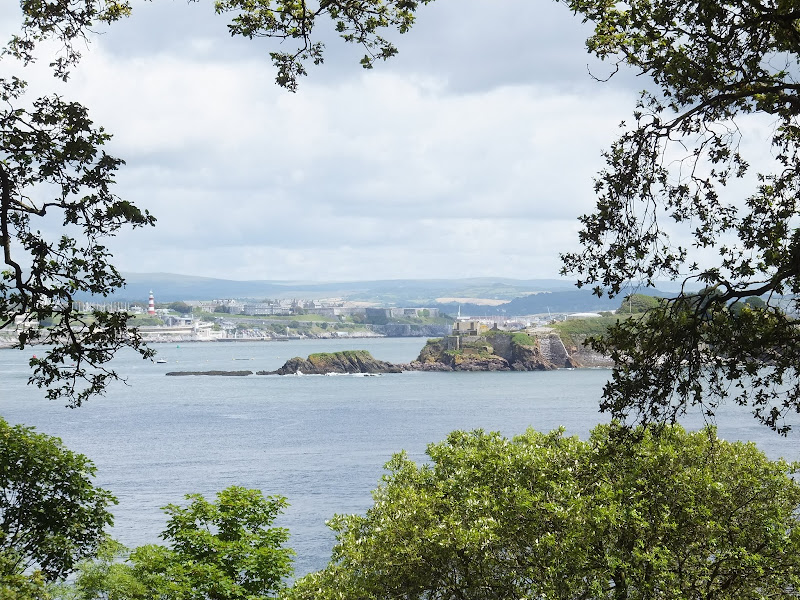
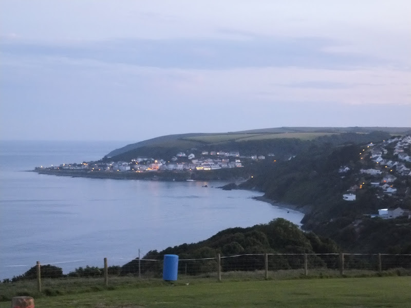
Cawsand is a small village at the centre of Cawsand Bay overlooking Plymouth Sound and within Mount Edgcumbe Country Park. By the seafront is a small square centred on a stone cross and surrounded by buildings including a pub called the Cross Keys. Narrow lanes lined with old houses lead away from the square, some so narrow it is hard to imagine just how a car can squeeze down them, but judging by the road markings, traffic was allowed access. As we wandered into this scene a little sign of sunshine sparkled into the cloudy sky. A patch of blue in the grey, and despite a spatter of fine rain it was a heartening sign. From Cawsand the path follows the coastline through Edgcumbe Park, firstly as an easy path along the cliffs but soon ascending into woodland with some tricky and slippery climbs and descents. All along this path are numerous architectural oddities. Stone seats in stone arches. Other arches containing either either a spring or water fountain. A folly ruin sitting on the hill above the path. A circular Ionic temple with inscribed plaques. Forts and defences. A lake. An orangery with landscaped garden including huge wire-framed insects and a spider climbing the central fountain.
The Cremyll to Stonehouse ferry is found just beyond Edgcumbe House and opposite the Edgcumbe Arms pub. The ferry runs every half an hour and arriving here just after 1pm, we had ample time to sit and relax over a well earned pint of ale and watch the ferry come and go. A chance to reflect over the days walk. Maybe, just maybe we should have included Rame Head in the walk. It could have been done. Maybe. Possibly. I always allow a speed of 2mph including stops, with an extra hour added for every 10 miles on more strenuous terrains. That should have been sufficient if the going was kind to us. But with the rain, the mud, slippery climbs, we could never be certain we would keep to time. Maybe one day we will return to walk Rame Head to walk around this and spend a little more time in the country park.
As it happened we managed to catch the earlier 3:35 train which got us back to Looe by 5pm. The journey had its own highlights. Brunel's bridge across the Tamar. The almost eccentric Looe branch line which loops around a valley and then has to reverse back down to Looe. At this point the guard has to exit the train and change the points to allow the train to run back on itself. These are the fascinations of a train-spotting childhood. I always remember that the Looe branch line was served by a single car DMU. It still is. This was my first experience of travelling on it. Delight!
It had been a long day and with the prospect of a further long days walking the next day I think I am safe in relating that both mentally and physically we were knackered. The idea of spending a few hours amid a crowd of rowdy drunken football fans was certainly not luring and it didn't take much to elect to return to camp and listen to the England match on the radio from where we could happily roll into bed for a good nights sleep. This turned out to be the best choice. England's performance was dreadful. Both TalkSport and Radio 5 live derided the way England had played. Italy commanded the game but despite this dominance it was 0-0 after extra time and once again England bailed out of a major competition on penalties but from the reports it was no less than they deserved.

Directions
Follow the well marked South West Coast Path trail which is marked with the usual National Trail Acorn waymarkers.
Alternative Route Cutting out Rame Head
As the path heads towards Rame Head, close to Captain Blakes Point, take the unclassified road through Trehill to Cawsand. This cuts off Rame Head and reduces the total distance of the official route of 24 miles down to a more manageable 20.6

Pubs
The Edgcumbe Arms, Cremyll View in OS Map | View in Google Map

- Address
- The Edgcumbe Arms, Cremyll
- Website
- www.edgcumbearms.co.uk/
A St Austells Inn on the banks of the River Tamar opposite the ferry offering accommodation, food including caraveries and a selection of St Austell ales.
By the time we reached the Edgcumbe Arms the sun was shining and there was plenty of people seated on the benches outside the pub enjoying views across the busy Tamar estuary. Three St Austell ales were on offer and I elected for the Diamond Jubilee special ale named Hop and Glory, at 4.7% this was a rewarding and refreshing golden coloured pint with hints of citrus. Went down a treat.
The Union Rooms, Plymouth View in OS Map | View in Google Map
- Address
- The Union Rooms, Plymouth
- Website
- https://www.jdwetherspoon.com/pubs/all-pubs/england/devon/the-union-rooms-plymouth
JD Wetherspoon's establishment offering the usual range of competitively priced food and drinks. Local ales on offer.
Typical JD Wetherspoons establishment but nonetheless having several ales on offer. I went for the Ein Stein from Stafffordshires Lymestone brewery - a full bodied 5% ale with flowery overtones, Kat went for the East Street from RCH but we had to swig the beer rather hastily in order to catch our train!
Bullers Arms, Looe View in OS Map | View in Google Map
- Address
- Bullers Arms, Looe
This 15th Century Cornish Ale house comprises of a single bar. Popular for live music, it also offers bar meals and a selection of 3 ales including offerings from Skinners, St Austell and Sharp breweries.
Very friendly staff who made us feel welcome from the outset. Good to see a variety of ales and the Skinners Cornish Knocker was a refreshing golden ale, slightly fruity but with a malty balance.
Ye Olde Salutation Inn, Looe View in OS Map | View in Google Map
- Address
- Ye Olde Salutation Inn, Looe
Traditional 16th century Inn featuring oak beams, log fires and typical olde world charm. The bars walls are adorned with local photos. Sharp's Doom Bar and guest ale on offer. Fresh crab sandwiches are available all year round along with lunchtime and evening meals.
Cosy little pub. They only had Doom Bar on offer when we visited but it is still a decent drop of ale even though I think it has paled a little since I first sampled it a couple of years ago.
Features
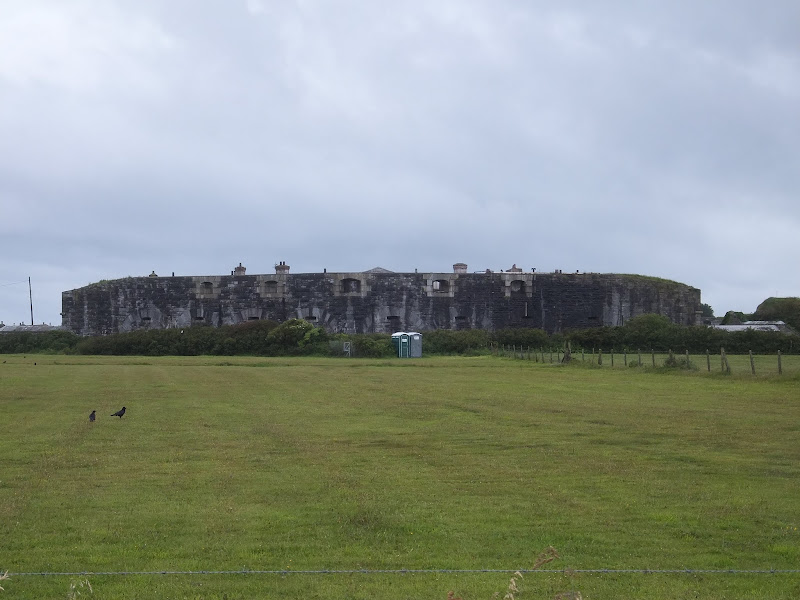
Tregantle FortView in OS Map | View in Google Map
Tregantle Fort is one of several forts surrounding Plymouth that were built during Lord Palmerston's premiership in the 19th century to deter the French from attacking naval bases on the Channel coast. Completed in 1865, the barracks had accommodation for 1,000 men and provision for 35 large guns though it has never been utilised to its full potential. After 1918 the fort was abandoned until 1938 when it was used by the Territorial Army Passive Air Defence School. The fort is presently used as a Royal Marine training area and is renowned for its rifle ranges which are located on the steep slopes down to the sea.
The fort has an irregular six-sided plan, with the gatehouse to the south east, the keep to the east, barrack blocks along the south and three caponiers facing west. It is built of snecked rockfaced limestone rubble with stone dressings.
References
Mount Edgcumbe Country ParkView in OS Map | View in Google Map
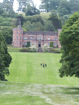
Mount Edgcumbe Country Park is an expansive area on the Rame Peninsula which includes a Grade II listed Manor House and gardens which are all under the ownership of both Cornwall County Council and Plymouth City Council. Built between 1547 and 1553, Edgcumbe House was the residence of the Earls of Mount Edgcumbe. During WWII the house was completely gutted by German bombs and was eventually restored in 1958 by the 6th Earl before the 7th Earl sold the entire estate on to its present owners. The site is a popular tourist attraction and has been open to the public since 1988. There are numerous structures and features to be found within the park including:
The Barn Pool which is a sheltered deep water anchorage,
A Bronze Age barrow
The Blockhouse which is a fort built in 1545 to defend the mouth of the Tamar
Milton's Temple, a circular Ionic Temple, built in 1755 and includes a plaque inscribed with lines from John Milton's poem Paradise Lost
The Picklecombe Fort Seat made from a doorway and enclosing a small niche with a piscina at the back. The carved stone comes from the churches of St. George and St. Lawrence at Stonehouse.
Thomson's Seat dating from 1760, a Doric pavilion with seats looking across to Plymouth Sound. Verses from Thomson's "The Seasons" are inscribed on the wall.
An 18th century folly made to look like a ruin and built from stone from the churches of St. George and St. Lawrence, Stonehouse.
An orangery built in the 18th century which is now a licencesed restaurant with landscaped gardens
References
Summary of Document Changes
Last Updated: 2021-12-07
Coast Walk, Cornwall, Distance:Hike, Features:Castles and Forts, Features:Parks, full-detail, OSmap:107, OSmap:108, South West Coast Path


0 comments:
Post a Comment