Paston Way to Gunton - Pubs, Churches and Wartime Conspiracies
|
Wednesday 18 December 2019
|
No comments |
![]()
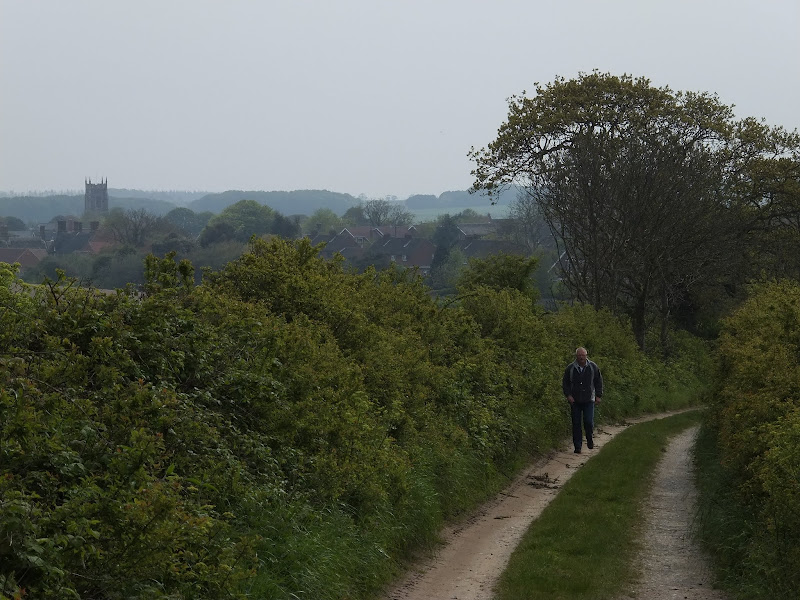
A 7 mile walk along Norfolk's Paston Way from Cromer to Gunton.
The Paston Way has a few alternative paths that stray from its main route between North Walsham and Cromer, and this walk takes the optional route out to Gunton from where a train can be taken back to Cromer. There are some worthy country pubs along this simple walk so a good old English pub crawl can also be had along with taking in the sights of the impressive churches at Northrepps and Southrepps plus local tales of wartime German conspiracies!
Cromer to Gunton Walk - Essential Information
Walk Statistics:
Maps:
The following maps and services can assist in navigating this route. There are links to printed maps and links to downloadable GPX route data for importing into navigational software and apps.
- Ordnance Survey Explorer Map
- OS Explorer 252 - Norfolk Coast East
- GPX Route File
Accommodation:
Woodhill Park CampsiteView in OS Map | View in Google Map
- Website
- https://www.woodhill-park.com/
- Description
- Located on the clifftops at East Runton, half way between Sheringham and Cromer, this highly recommended touring site is ideal for exploring North Norfolk with public transport available to many destinations from the entrance to the site.
Transport:
Details of public transport that is required for the walk
Greater Anglia Trains - bus Service
- Service Details
- 4/5 - The Bittern Line - Railway line linking Norwich, Cromer and Sheringham
- Timetable
- https://bitternline.com/
Route Verification Details
- Date of Walk: 2012-05-18
- Walk Time: 14:00 to 17:30
- Walkers: Griffmonster, Kat
- Weather Conditions: Overcast but dry
Walk Notes
We started and ended the walk at Woodhill, East Runton, making the total distance of 10 miles. This certainly is a good easy afternoons walk. Unfortunately the weather wasn't its best with a lot of low cloud and a chill north-easterly breeze that blew against us. As the coast curved to Overstrand, the wind appeared to get warmer and then leaving the coast it dropped completely. Even so, the beach section from Cromer to Overstrand is always a pleasure to walk. There is something fascinating about clambering over seaweed encrusted groynes, and bridging the riverlets and sand pools that the outgoing tide leaves.
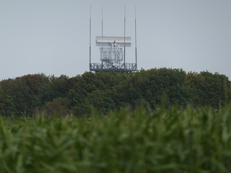
Coming out of Overstrand, up the lane and over the old railway, the most striking thing that immediately catches the eye, poking enigmatically above the hedgerows, is the revolving NATS Air Traffic Control Radar Station. This sits on Hungry Hill, which is the official route of the Paston Way and can also be taken to get to Northrepps. This route is well worth investigating if you have never walked it previously, the highlight being the legendary shrieking pit which is detailed in the post for the full length route of The Paston Way Walk.
As the lane starts to descend to Northrepps, one can see St Mary's church nestling in the hills of what some would say is untypical Norfolk countryside. Most folk probably associate Norfolk with being flat but the views here would certainly dispel any such notion. With the misty haziness, this rural scene could easily pass as a picture from Yorkshire rather than Norfolk. So don't dispel this fine county as being a flat and featureless landscape when it has such fine scenes as this.
The trains that stop at Gunton are few and far between, restricted mainly to peak hour times so one needs to plan this walk carefully, either taking the train to Gunton at lunchtime and walking back or making certain there is enough time to meet with the train back. On this occasion, having set out after the last lunchtime train to Gunton, we were aiming to catch the 5.20pm service back to Cromer. Starting out at 1.30pm, we considered there was ample time to stay within our schedule, until we found the White horse open at Overstrand...... and the Foundry Arms at Northrepps.... it would have been rather rude not to pay these hostelries a visit, but with time ticking away especially after taking time out at Northrepps church, it soon became apparent that we needed to up our pace to stay on schedule. It was with a little regret that we had to miss out the Vernon Arms at Southrepps, it looked very inviting. Never mind, it will still be there for another walk, another time, another occasion, probably Southrepps to Mundesley. Unless it succumbs to the same fate as the unfortunate Suffield Arms, opposite Gunton Station, which we found closed down, fenced off and boarded up. I truly hope not, we need to keep our traditional English Inns open and alive. They are part of our heritage. They are a part of our social make-up. They are what makes the English countryside what it is. The way things are going the typical English country postcard will soon be changed to depict the village green with a game of cricket in progress and a church clock tower in the distance and the boarded up old pub that was sacrificed as part of the British Governments crusade against alcohol. The Suffield Arms was once a fine pub, and, so I have been told, it was built by Lord Suffield for the commoners such that they did not visit the nearby Gunton Arms which was for the gentry. In my times in Norfolk, this pub was a regular host for beer festivals, and always had a good range of guest ale. In 2011 it closed its doors for good and in the intevening years it became an empty decaying building. In 2016 it was bought by one Ivor Braka, an art dealer and current owner of the Gunton Arms with the intention renovating the building and reopening it as a pub. He has been quoted as saying the reason for this is ...because I genuinely don’t want to see the life-blood sucked out of the countryside
. Good on him.
To end on a more positive note, Gunton Station is worth the visit just to witness the preservation it has undergone. The Station name is peculiar in the fact that there is no village by that name, the station is actually located in the parish of Thorpe Market and was built for the convenience of Lord Suffield who lived at Gunton Hall. The northbound platform and buildings were bought by the Lord of Thorpe Market, Stanley Hurn in 1989 and have now been restored and renovated and has received multiple conservation awards for the results.

Directions
A beach walk to Overstrand is followed by tracks, lanes and footpaths across to Northrepps, Southrepps and ending at Gunton railway station.
The Paston Way officially starts at Cromer Pier and then follows the promenade east out of Cromer. At the end of the promenade a ramp leads down onto the sandy beach. Below high tide there is firm sand which can be walked across with ease, negotiating around the groynes as best as possible. Overstrand is signalled by another promenade. Walk up onto this then up the steep path to the top of the cliffs. Follow the road to the left, keeping to it as it bends round to the right, past the cafe. At the end of the road is the White Horse pub. Turn left and follow the road through the village, keeping to this road as it turns sharp right and up to the main road. Officially the Paston Way continues left along this road to the turning up to Hungry Hill on the right, but for this walk there is a track opposite the junction. Take this, around the double bend, over the old railway and down to Northrepps. The track turns into a road that leads into the centre of the village. Continue straight ahead until the road bends sharp left. The Foundry Arms is just around this corner. The Paston Way continues turning right and following the road around past the church. Once out of the village take the lane on the left and keep to this until the Rectory on the right. Take the track down the side of the Rectory and follow it around the corner. Keep to this track, over the road until it emerges at a corner on a road. Turn right and follow the road into Southrepps. Continue straight ahead through the village until it junctions with B1436, with the Vernon Arms to the left of the junction. Go straight over and follow the footpath along the field boundary. This emerges at a road junction. Go straight over and follow the road down to the next junction. Turn right and the railway station is on the left.

Pubs
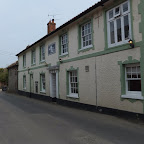
The White Horse, Overstrand View in OS Map | View in Google Map

- Address
- The White Horse, Overstrand
- Website
- www.whitehorseoverstrand.co.uk/
This AA awarded 4 star guest-house and hostelry offers eight individually furnished en-suite rooms, a first class restaurant serving top quality cuisine, an extensive wine list and a well stocked bar with guest local Norfolk ales. There is a tidy garden at the rear and a minimalist clean bar area. Guest Norfolk ales and a variety of food.
On the last visit to The White Horse they had a Humpty Dumpty ale on tap so I was hoping for some more. I was not disappointed and, even better, was the fact that it was an ale that I had not sampled before. Humpty Dumpty East Anglia Pale Ale was a blonde beer with a dry finish to it, very refreshing and typically Humpty Dumpty.
The Foundry Arms, Northrepps View in OS Map | View in Google Map
- Address
- The Foundry Arms, Northrepps
- Website
- https://www.northnorfolkpub.co.uk/
A charming family run Norfolk country pub serving good, honest locally sourced food. The pub has been around since the mid 19th century and has had several similar names including Foundry and Mark Lane Arms and The Market Lane and Foundry Arms. Each name reflects the location of a nearby foundry where the Gallas plough was developed in 1830 which became widely used across Norfolk until the 1920s. The church weather-vane depicts a plough in commemoration of this innovative design.
The pub has its smuggling connections, with a wheelwright known as 'Old Summers' being the ringleader of the smuggling activities. Local folklore tells of one occasion when the smugglers tied the chief preventive officer to a post while they hid away their booty. Of course no-one had witnessed this when the village folk were questioned. Their activities were aided by a lady called Sally Bean who used to live in a cottage on what is now known as Nut Lane, but was commonly called Shucks Lane after the legendary ghost dog. Her cottage sat atop a hill, the highest ground around and consequently had good views all around so that early warning could be given if the preventive men were on the prowl.
In 1880 the pub was taken over by Bullards brewery before Watney Mann took the Norwich brewery over. It is currently a free-house The pub bar is open all day, every day from 12 Noon for drinks and coffee. Food is served lunchtimes and evenings and available on Sundays from 12 Noon until 3.30pm.
Charming village pub and remarkably busy for the time of the day with the bar surrounded by locals busy in talk and chatter. Some First Bittern ale from Woodfordes was on offer along with Wherry. A splendid country pub and well worth a visit
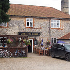
Vernon Arms, Southrepps View in OS Map | View in Google Map
- Address
- Vernon Arms, Southrepps
- Website
- www.vernonarms.com/
Dating from the mid 19th century, this brick and flint building was formed from three cottages. It is said that manor courts were held here in the 1800's.
Today the pub is a popular old-fashioned village pub serving food including local crab and lobster specials and guest ales. Children, dogs and muddy walkers are always welcome.
Unfortunately, due to time constraints we could not stop at this inn, though judging by the number of people that appeared to be standing at its door, it was a popular little pub.

Features
The Conspiracy of The Norfolk German Landing GroundsView in OS Map | View in Google Map
Although not specific to Southrepps this curious story nonetheless involves buildings around this area and many claim some of these red roofed constructions still exist.
During World War II, with the threat of an invasion by Germany, East Anglia was at the forefront of the defences as can still be witnessed by the numerous pill boxes that dot the coastline, and even, if one looks close enough at the landscape, the remains of trenches designed to counteract any attempt by the German Luftwaffe to land their gliders. One story, which probably has not had as much attention, and some say borders on conspiracy, is that of the German Landing Grounds that were said to have been discreetly laid out across Norfolk with red roofed barns marking out the flight-line. Although this was just folklore and locals' tales, in 2006 former Flight Commander Peter Meston broke his years of silence to reveal some insights into the truth of the stories.
During the war Peter Meston was stationed at RAF Watton and was flying missions in Blenheim bombers along with a New Zealander called David Watson. Returning from one mission Watson happened to notice a peculiarity on the landscape below. Strategically placed across the landscape were numerous mounds of lime laid out in long lines with what appeared to be arrowheads on one end. On his return, he immediately told his comrade of his findings. At first Peter Meston refused to believe him but on accompanying the pilot on a further flight, the signs stretching over the villages of Sporle, Beighton, Cantley, Halvergate, Paston, Guestwick and Southrepps were unmistakable. It was true that lime mounds were a common sight in Norfolk as it was a major part of the sugar beet industry, but to have these mounds forming straight lines across the landscape seemed very suspicious.
Returning to base, they informed their superiors and despite reservations about what the pilots had found, eventually word got through to high places and soon the airbase was swarming with MI5 agents and the two pilots who had broke the news were told that the information was top secret and they should not speak to anyone about their findings which they have done until now.
Although Peter Meston does not mention any red roofed barns, he is still convinced there was German infiltration into Norfolk and they had managed to mark out the flight-paths ready for an invasion. This is supported by evidence in an obscure file coded Air2/4557 and found in the public records office by a 1998 researcher. This reputedly reveals details of how the German Luftwaffe had prepared a series of landing grounds in Norfolk during the lead up to the war. There were seven separate locations each with one or two distinctive red roofed barns and each of these sites was owned by the same property company, registered as Dutch but with German connections. This ties in with an account from Geoffrey Claxton who remembers as an 8-year old just before the war and living in the village of Guestwick in Norfolk. He recalls a Dutch agriculture firm using German builders to construct large red roofed barns. His folks had two of these workers as lodgers and each morning they would give the customary 'Heil Hitler' salute before heading off to work.
Other unsupported tales and folklore reveal that these farms even had chicken hutches arranged in swastika formation and claims that some of the farms had removed hedgerows and laid flat the land to accommodate airstrips on them.
Yet another story comes from my own locality in Suffolk. This tale was revealed a few years ago by a lady from Aldringham whom I shall call Mrs P. She recalled the time when she was younger and worked as a housekeeper to a seemingly wealthy family by the name of Burrows, who lived in a large country house in Aldringham. The Burrows had moved to the area prior to the war and they were an odd family who seemed to have no connection with the locality. It wasn't until after the outbreak of war that Mrs P's suspicions were aroused when one of their children let it slip that the family name was not Burrows but Burrowitz and they were of German origin. This was obviously a great cause for concern and despite reservations about informing on her employees, Mrs P. decided to pass the information on to the authorities. She was told to carry on her work as normal so as not to arouse suspicion and the matter would be investigated. This she did, but it was not long before one day, out of the blue, the family up and left in a hurry, taking little of their belongings with them.
Wanting an explanation, Mrs P was told that the gentleman, Mr Burrows aka Burrowitz, was indeed a German and had spent the years prior to the war buying up property in East Anglia, being funded by the German government. The farms and houses that he had bought formed a straight line across the landscape and each of these buildings had their roofs painted red which were to act as a flight-line for the German Luftwaffe to follow in the event of hostilities.
Of course the story is still controversial and sceptics have suggested that the formations were merely decoy markers bent of tricking German bombers to attack dummy targets. Another theory suggests that the tales are all just fiction based upon a Biggles novel. Despite this there appears to be too much evidence and memories to suggest otherwise and the fact that the tales come from a wide range of sources would support that there must be some grain of truth within them.
References
Church of St Mary the Virgin, NorthreppsView in OS Map | View in Google Map
The church dates from the 15th century though some aspects are from earlier with the stone being transported from Yorkshire. Most of the present building owes much to restoration undertaken during the 19th and early 20th century including the east window in the south aisle which depicts the archangels Gabriel, Michael and Raphael with a host of angels above them. Above the door is a frieze of the royal arms depicting the lion and the unicorn and labelled for George III. However these are actually the early Stuart arms of Charles I of a century and a half earlier. I think that they are the arms of Charles I. Curiously, the lion appears to have had his manhood erased, but not the unicorn. There is also a 15th century rood-screen which was said to have been found in a local barn by rector of the church, John Cresswell, in 1912.
Church of St James, SouthreppsView in OS Map | View in Google Map
The huge church at Southrepps can be seen for miles around and its tower is one of the tallest in the county. The base of the tower is decorated with scallop shells, the pilgrim symbol of St James. The building was constructed in the 15th century with the chancel being restored in the 19th century.
References
Gallery
Below are a selection of images taken from from the photo album for this walk. Feel free to browse through these or click on an image to view a larger version in the Gallery.


Summary of Document Changes
Last Updated: 2021-12-12
Coast Walk, Distance:Medium, Features:Churches and abbeys, Features:Folklore, Features:Local History, full-detail, Norfolk, OSmap:252, Paston Way, Pub Crawl


0 comments:
Post a Comment