A Walk to Languard Fort
|
Tuesday 4 December 2018
|
No comments |
![]()
A 10 mile walk from Trimley to Languard Fort via Felixstowe Ferry
This walk navigates from the village of Trimley down to Kings Fleet and along the banks of the River Deben to Felixstowe Ferry, the setting of an old Black Shuck tale from many years ago which is a feature to this walk. A coastal walk follows, along the seafront of Felixstowe through to the where the River Orwell meets the sea, a strategic point of defence against attacking enemies attempting to sail up the estuary. Key to that defence is Languard Fort which has stood here for many centuries and has played key parts in the world wars of the 20th centuries. A fascinating place to visit with a certain eeriness within its confines.
A Walk to Languard Fort - Essential Information
Walk Statistics:
- Start location: Trimley
- End location: Languard Fort
- Distance: miles ( km)
- Total Gain: ft ( metre)
- Total Descent: ft ( metre)
- Min Height: ft ( metre)
- Max Height: ft ( metre)
- Walk Time:
- Walk type: Linear
- Walk Grade: Easy
- Terrain:
Maps:
The following maps and services can assist in navigating this route. There are links to printed maps and links to downloadable GPX route data for importing into navigational software and apps.
- Ordnance Survey Explorer Map
- OS Explorer 197 - Ipswich, Felixstowe & Harwich
- GPX Route File
Transport:
Details of public transport that is required for the walk
First Group - Bus Service
- Service Details
- 75/76/77 - First Group 75/76/77 bus services connecting Ipswich, Trimley and Felixstowe.
- Timetable
- Suffolk On Board Website
Route Verification Details
- Date of Walk: 2012-04-07
- Walk Time: 10:00 to 15:00
- Walkers: Griffmonster, Kat
- Weather Conditions: Cold and blustery day with showers
Walk Notes
The route taken here was part of the old Stour and Orwell Walk, a long distance path around the Stour and Orwell river estuaries that started at Felixstowe Ferry and ended at Manningtree with an inland option via Trimley to miss out Felixstowe. The path route was reconfigured during 2012 when the inland route was removed altogether and the seafront section past Felixstowe to Languard Fort was re-classed as part of the Suffolk Coast Path. The Stour and Orwell Walk now starts at Languard Fort and follows the Suffolk Coast Path for several hundred yards along the coast before heading inland to rejoin the estuary coast beyond the docks.
There is a regular bus service between Felixstowe and Trimley going onto Ipswich, with one bus each hour that continues on from Felixstowe down to Languard Fort, operating as the 77 Service. An alternative option for this walk is to continue up the estuary to Loompit Lake where there is a footpath through to Trimley to make a circular route. This path formed part of the old inland route of the Stour and Orwell Walk.
This walk was undertaken on a blustery, overcast day which had regular showers of fine rain blowing across the meadows around the Deben estuary. The first encounter with the river is a creek known as King's Fleet, named after Edward III assembled his fleet on its waters in 1338 in preparation for a French campaign that was to be the start of The Hundred Years War over the right to rule the Kingdom of France. The creek is no longer navigable being cut off from the Deben by the earthen defence banks.
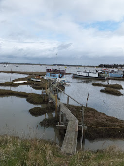
As the fishing hamlet of Felixstowe Ferry is approached, one is greeted by a menagerie of river craft moored in the sheltered haven just north of the village. A mixture of old houseboats, weathered vessels that look like they have not move from the moorings along with more modern pleasure and sailing craft. A decaying hull rests on its side on a mud bank. Particularly amusing is the boat named Potamus with a fine display of caricatures, comical cartoons and effigies of hippopotamuses. Inside the boat are a multitude of faces staring out of the windows. One assumes they are no more than dummy heads rather than something sinister. The boat, surrounded by precarious wooden boardwalks is always a feature to stop and amuse oneself each time of passing this way. There is always something new to witness. Another sign. Another model hippo that had not been noticed before. Signs are emblazoned across the boat. Beware of the hippopotamus
, another in capital letters screams HUTOMUS
. A left-belt is marked with Pottering About
. When the tide is out the boat rests on the mud and more hippos are revealed along with a diver at the base of a ladder, his helmet and one hand appearing out of the mud. The boat, a 1940s liberty boat that had been converted into a fishing vessel was purchased in 1984 after the previous owners had run up large mooring fee debts and the boatyard took possession of the craft. The new owners, Mick and Sandra Goddard had an old VW camper that they had named Hippo on account of it resembling such a beast. With the purchase of the boat it was soon agreed to continue the theme and consequently the name of Potamus was chosen. The full story can be found in the Spring 2013 edition of The Deben
Felixstowe Ferry is always a curious name for the uninitiated who visit the area. It is a hamlet in its own right and not part of or connected to the town of Felixstowe other than by name. The village is still home to fishing boats and the ferry which operates across the mouth of the River Deben to Bawdsey. The area is popular with day trippers and tourists and the Ferry Cafe and the Ferryboat Inn are always busy at weekends, as are the various shacks selling freshly caught fish. The village church of St. Nicholas's is a modest building that is not much more than a prefab hut that is sited behind the Martello Tower. A plaque informs that it was built in 1954 on the site of the former church which date from 1878 but was destroyed in 1943 during an air raid. The village once boasted a second pub, The Victoria which permanently closed its doors to the public in 2010.
The walk route now follows the promenade that runs through to the start of Felixstowe. A walkway that passes two Martello Towers and is a popular route for many locals and visitors. The first section of the path which faces the open sea is a former Roman burial ground, probably part of a Roman settlement or port. In 1850 four bronze armlets with two skeletons after the cliffs eroded and just out to sea are the remains of a Saxon Shore fort, part of the 3rd century Roman coastal defences. Known as Walton Castle after the parish it was located in, it fell over the edge of the cliff in 1766. Nothing can be seen of the remains of the structure although drawings from the 17th century depict a fort similar to that of the Saxon Shore Fort at Burgh Castle in Norfolk.
Beach huts mark the start of Felixstowe although really we should call this side of the town Walton after the village that got amalgamated into the expanding town. These days it is just marked as old Felixstowe on maps and the name of Walton has been forgotten. Felixstowe proper does not start until although and one has to head up to the road in order to get around Cobbolds Point such is the extent of erosion of the beach. Given a low tide the beach route is accessible and is certainly a preferable route than using the urbanised roads.
Languard Fort was originally known as Langer Fort according to John Kirby, writing in 1764, adding that it takes its name from Langer Common on which it was built from which the name was vulgarly corrupted to Landguard. Eventually the d
dropped out of the name. Further to this, William Camden writing in 1610 states that the name came from a ridge of land stretching out into the sea which was called Langerston on which the local fishermen laid their nets. It was this ridge that gave the name to the fort, the common and the marshes.
The Fort is an impressive structure although it is pretty much hidden until one is virtually standing in front of it when approaching from the coast, masked by the dunes on Languard Common on one side and the vastness of Felixstowe Port on the other. If one wants to visit, it is best to allocate a full afternoon as there is a lot to explore. Indeed, our visit occured some weeks later, the photos which can be found here.

Directions
The walk follows the former route of the The Stour and Orwell long distance path, initially along the old inland route, and then along the coast from the Deben to the Orwell. From February 2012 Suffolk Coast and Heaths cut the inland route and the coast path section of the The Stour and Orwell Walk from its official route. The start to the route is now at Landguard Common, Manor Terrace Car park, and joins the original route where it cuts inland along Beach Station Road. Nonetheless there are still waymarkers along the former inland section and the coastal section is marked with the Suffolk Coast Path waymarkers.
Trimley to the River Deben
The route follows Mill Lane on the Ipswich side of Trimley which leads out across the A14 trunk road and then along the country lane towards Falkenham. After leaving the A14, just before a wood on the left, there is a footpath diagonally across the field, through the wood and then diagonally across another field. At the far end it emerges back onto the Lane down into the valley of the Falkenham Brook. As the lane leads back out of the valley there is a footpath on the right which leads along the field boundary, eventually crossing this and a field to the lane to Deben Lodge Farm. Keep on this lane, past the farm, where the lane turns into a track and leads down to Kings Fleet. Keep along the side of the Fleet through to where the river defence blocks its navigation to the Deben. Climb up onto the earthen defence, taking the path to the right, following the Deben into Felixstowe Ferry.
Felixstowe Ferry to Languard Fort
The footpath leads onto the concrete walkway alongside the sea. Keep to this all the way down to Felixstowe. Just before Cobbolds Point it is necessary to climb up the cliff on the public steps, and walk along Cliff Road, then left into Maybush Lane back down to the seafront. Keep to the seafront all the way through to where the official route turns inland to navigate behind the docks. At this point continue along the seafront, past the last Martello Tower and onto Languard Common. Take either route along the common which eventually emerges at Languard Fort.

Pubs
The Ferryboat Inn, Felixstowe Ferry View in OS Map | View in Google Map
- Address
- The Ferryboat Inn, Felixstowe Ferry
- Website
- www.ferryboatinn.org.uk/
The site of the inn was originally a fisherman's hut for selling fish and dates back to 1043. The present building dates from the 15th Century when it was the home to the Ferry master. It became a hostelry in the 16th Century. The hamlet it sits in is presently known as Felixstowe Ferry which dates from the 19th century. Before this time is was known as plain Felixstowe and the present town that bears this name was then known as the Waltons.
The Inn offers a range of food with daily specials displayed on a blackboard. Guest ales are available.
Pub oriented to the tourist trade but has some good old photos and a table set out with newspapers and books including a book of old photos from the area which proved to be very interesting. Three ales were on offer, Adnams bitter, Woodfordes Wherry and Timothy Taylors Landlord. I opted for the Landlord as I had not sampled this ale for a few years. A good accompaniment to a beef baguette.
St Judes Brewery Tavern, Felixstowe View in OS Map | View in Google Map

- Address
- St Judes Brewery Tavern, Felixstowe
Formerly known as The Old Millars on Felixstowe seafront, this grand building has now become the outlet for Ipswich microbrewery St Judes. The pub offers up to 30 real ales straight from the cask, a wide variety of European lagers, ciders and wine. Bar snacks and hot pies available everyday. An ale drinkers paradise!
Sadly, due to difficult trading conditions the St Judes brewery closed for business in May 2012. This is a big loss to both local micro-brewing and as an exceptional real ale pub that offered probably the largest range of ales in Suffolk. More recently the Brewery has relocated to Matthews Street, Ipswich
When we stepped into this large seafront pub we were confronted with a blackboard listing 24 ales including a selection of their own St Judes beers. Initially we thought this must have been a beer festival, but no, this is the selection of ales that are regularly on offer. I opted for the Raven ale from Sinclair brewery, part of the Orkney brews, a hoppy golden bitter that was very refreshing. Kat went for Hopbacks Spring Zing, a golden ale with a hint of grapefruit and very drinkable. This pub is well worth seeking out and I will make an excuse to visit it again!

Features
Martello TowersView in OS Map | View in Google Map
Three Martello Towers sit alongside the seafront at Felixstowe
Between Felixstowe Ferry and Languard Fort there are three Martello Towers, all in a good state of repair. These formed part of an original defence of 103 towers along the east and south coasts of Britain. They were built between 1805 and 1812 during the time England was at war with France and were a measure against the potential invasion by Napoleon which never took place. There were 29 of these distinctive round structures built along the Suffolk and Essex coasts, each one constructed of brick with their walls up to 13 foot thick on the seaward side and approximately 30 foot tall, originally equipped with a canon on the roof.
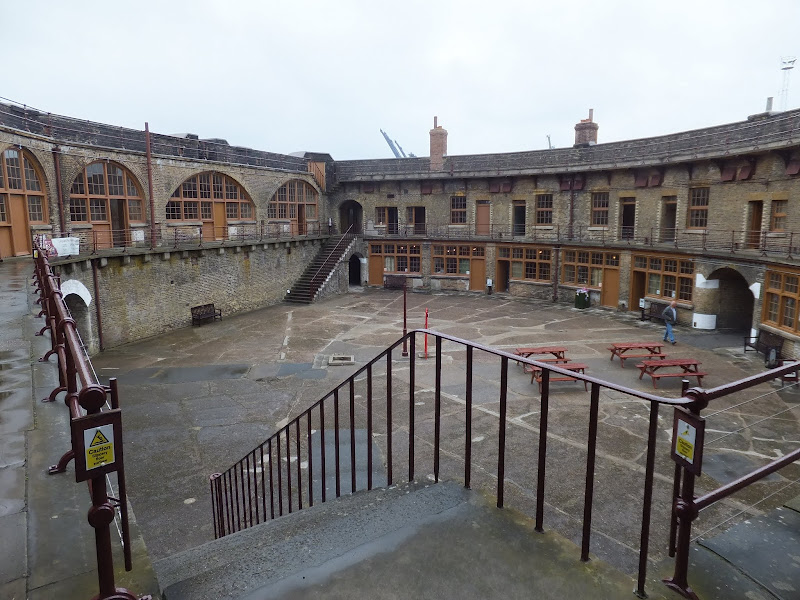
Languard FortView in OS Map | View in Google Map
An historic Fort that defends the mouth of the River Orwell and dates from 1543
The north side of the point where the Orwell joins the open sea is known as Languard Point and it was here that a fort was originally built in 1543 by order of Henry VIII. Within a few years these blockhouses had deteriorated and their defensive guns were returned to the Tower of London. A replacement fort was built in 1628. This was a square structure of earth and wood with a bastion on each corner. This was strengthened with a brick wall around the fort in 1666 and the following year seen its first combat as an invasion from the Dutch navy was repelled by the Duke of Yorks Albany Maritime Regiment of Foot.
A new brick Fort was constructed in 1717 and this only lasted until 1744 when it was replaced with a red brick fort in the shape of a pentagon, the walls of which still remain to this day. The structure was remodelled in 1871, and in a 1878 submarine mining establishment was excavated from a room within the walls of the fort. More alterations occurred in 1901 and for the most part of the 20th century the fort was used as barrack accommodation, with a control room set up in 1951 for use during the 'cold war'.
The fort was finally vacated in 1956 when it was considered as no longer needed as part of the national military strategy. The complex was sealed up and left to decay until the 1980's when local interest set about restoring the fort, eventually falling into the hands of English Heritage who now maintain the building and open it to the public.
The Fort has several ghost stories and is the subject of frequent Ghost hunts and ghost tours. A solitary musketeer was seen by several soldiers during the second world war. A Victorian Artilleryman has been seen to step through the wall of what is now the shop which is also said to be the scene of poltergeist activity including things being thrown off the shelves. The bathroom is said to be haunted by another soldier who was believed to have hanged himself there.
The ghost of a Portuguese lady named Maria who cries out in the night and occasionally whispers in a foreign tongue. Maria was the wife of the forts paymaster sergeant during the mid 18th century. She was not particularly liked by the wives of the other soldiers and when a silk handkerchief went missing, the finger of blame was firmly pointed at Maria. Set on proving his wifes innocence, the paymaster sergeant set off to find help in gaining evidence. He was gone from the fort for four days and on his return was accused of desertion and promptly executed by firing squad. Maria was so devastated that she flung herself from the ramparts to her death. From that point her ghost has been heard by many unsuspecting visitors.
The Chapel Bastion, which used to have a chapel attached to it, is reputed to be haunted by a young Georgian soldier who died from a tropical disease that he contracted during his posting abroad. On his return the symptoms manifested and he was secretly quarantined in order not to spread fear and panic amongst the other soldiers. He was the only son of a widow and had wanted his mother to know that he had not deserted her but due to his illness was not allowed to see her. He is sometimes heard crying and has been seen crouching in a corner of the room. Whenever the door to this part of the fort is propped open it mysteriously shuts on its own.
References
A Curious Tale of Black Shuck at Felixstowe FerryView in OS Map | View in Google Map
A piece of folklore of the East Anglian canine spectre, Black Shuck
This is an interesting tale from a publication by Morley Adams that was published in 1915. As many will well attest East Anglia is the haunt of a ghostly black dog with fierce red eyes, commonly known as Black Shuck, portender of doom and death. Even to the modern day there are reports of sightings of this menacing hound whose hunting grounds are predominantly the Norfolk and Suffolk coast. It is said that occasionally Black Shuck will assume the form of a human and this story from the beach-folk of Felixstowe Ferry attests to such an occurrence.
The tale starts with the arrival in the small hamlet of Felixstowe Ferry of a strange gentleman with a darkened complexion. No-one knew where he came from and although he could speak English well he never spoke of his origin. The locals had assumed him to be of Mediterranean origin, soon giving him the simple name of 'The Italian'. As time passed he became accepted by the village folk, in particular by a local fisherboy whom appeared to warm to his company. Eventually, The Italian confided with the boy that he had to return to the 'foreign parts' from whence he came and tried to persuade the lad to accompany him on the journey. The lad refused and The Italian was left to depart alone but entrusted the boy with his large black dog during his absence. Although the locals, and indeed the boy, had seen this large black hound around the village ever since The Italian had arrived, they could not help but notice that the two were never ever seen together. In fact no-one had seen them within sight of each other and this was a topic of many a conversation.
Despite his initial qualms, the fisherboy soon became attached to the dog and it wasn't long before they could both be seen out swimming in the sea as was the lads custom. Then one fateful day he swam out a little further than was usual. On attempting to come back to the shore he was horrified to find that the dog would not let him, growling and snapping at his legs and neck and driving the lad further and further out to sea. The lad was fearful that he would end up drowning but with the fierce growling and panting behind all he could muster was to swim further out into the sea. Eventually he plucked up the courage to turn and confront the hound but was horrified to see not the large black shaggy dog but the scowling face of The Italian staring straight at him with a hellish grin. Then, in an instant he resumed the form of the dog and immediately went for his neck with a savage snarl. As luck would have it, a sailing ship had heard the boys cries and raced to his aid, hauling him from the waters to find his neck lacerated from the dogs teeth. Looking back they saw the dog dive beneath the waves like a whale and was gone from sight. From that moment on the dog was never seen again and The Italian never returned.
There is no date to the story, other than the copy date of the original book by Morley Adams, who declares that he spent many fascinating hours listening to the legends and folklore from Norfolk and Suffolk village folk.
References

Links and Bibliography:
Gallery
Below are a selection of images taken from from the photo album for this walk. Feel free to browse through these or click on an image to view a larger version in the Gallery.


Summary of Document Changes
Last Updated: 2021-12-07
Coast Walk, Distance:Medium, Features:Folklore, Features:War Heritage, full-detail, OSmap:197, Suffolk, Suffolk Coast Path


0 comments:
Post a Comment