Ouse Valley Way - Oakley to Carlton
|
Tuesday 24 December 2019
|
No comments |
![]()
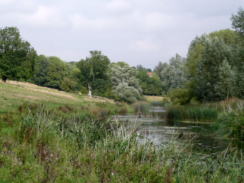
A 13 mile North Bedfordshire walk along the Ouse Valley Way between Oakley and Carlton taking in the charming villages of Pavenham, Sharnbrook, and Odell.
Although the Ouse Valley Way does not actually go into Oakley, there is a convenient bus stop here that links the two ends to this walk. The bus stop is a mile or so from the river, from where there is a footpath which joins the official route at Stevington and then winds its way through the rolling Bedfordshire countryside. There's plenty to see and explore along the route with medieval river bridges, the Holywell at Stevington, the ghostly tales of Odell and the picturesque villages of Pavenham, Radwell, Sharnbrook, and Harrold. Although many of the villages pubs have finally closed their doors for good in recent years, there are still convenient refreshment stops on route.
Oakley to Carlton Walk - Essential Information
Walk Statistics:
Maps:
The following maps and services can assist in navigating this route. There are links to printed maps and links to downloadable GPX route data for importing into navigational software and apps.
- Ordnance Survey Explorer Map
- OS Explorer 208 - Bedford & St Neots
- GPX Route File
Transport:
Details of public transport that is required for the walk
Grant Palmer - bus Service
- Service Details
- 25 - Grant Palmer 25 Service from Rushden to Bedford
- Timetable
- https://www.grantpalmer.com
Route Verification Details
- Date of Walk: 2011-09-03
- Walk Time: 11:30 to 17:30
- Walkers: Griffmonster, Kat
- Weather Conditions: Sunny day
Walk Notes
This area of north Bedfordshire was where I first started walking during my teens and early twenties. In those days it provided me and several friends ample opportunities to pub crawl around the numerous country hostelries. No matter what time of year or what the weather, we would willingly walk the seven miles from Rushden out to Sharnbrook then meander through the villages, often heading all the way through to Turvey and back. With these memories, it was somewhat sad to come back and witness the numerous pubs that have now closed down for good. Harrold used to have three, The Magpie, The Globe and The Oakley and this has now been reduced to one although The Oakley is still under ownership by Charles Wells but definitely closed throughout the weekend we was there (NOTE - this has subsequently reopened and as of 2018 is open for business). Other pubs now gone include The Swan at Radwell, The Red Lion at Stevington, The Mad Dog at Odell and the Royal Oak at Carlton. Such wholesale closures is a sad reflection on these village communities and their social life. As we walked out of Radwell it was all too clear that the inhabitants of this village were no more than city slickers who used the village as their dormitory. Very sad indeed.
Together with these pub closures it would appear that my favourite pub game of Cheese Skittles is going the same way. Many happy hours of my youth were spent throwing cheeses against the 9 skittles on the leather table. This game was unique to North Bedfordshire and Northamptonshire. It was noisy, skilful, some times dangerous but fun and free. I would have loved to have shown Kat how to play a game but, alas, not once did we encounter a single table throughout this expedition. Having said that, I have since been reliably informed that a few do still exist - these being in the Bedford Arms at Souldrop, The Swan at Newton Bromswold and the Bell at Little Addington plus one located in a railway carriage at the Rushden Historical Transport Society. If you see this game DO please play and keep the old traditions alive, its a fantastic game without a doubt and probably one of the few things I do miss from the area since I left.
The reason for this particular visit to the area was a family occasion, but we couldn't resist going a day earlier and camping in a friends garden at Harrold in order to do a little walking. There is a bus linking Harrold, Carlton and Oakley and terminating in Bedford but the timetable that we downloaded from the Internet was totally wrong. Nonetheless, there was still an hourly service which is more than I remember from the days of my youth. Bedford was a little too far to walk for the time we had on this occasion so we walked to Carlton, got the bus to Oakley then walked back to Harrold. There are parts of this which I had not walked before including Pinch Mill islands which is quite a magical little place. I cant believe I have never explored these before, having walked the path between Sharnbrook and Felmersham on many occasions. The waters here are very shallow owing to the years of silting up and as on passing we encountered a gang of kids, one who excitedly exclaimed, 'We have caught a crayfish, do you want to see it mister?' What a truly brilliant way to spend ones childhood. I really had forgot exactly how good this part of Bedfordshire was.
Directions
Follow the river from Oakley through to Stevington where The Ouse Valley Way is clearly waymarked all the way through to Carlton
The number 25 Grant Palmer Rushden to Bedford bus stops at the crossroads on the edge of Oakley. From here head down the High Street, then left into Church Lane at the bottom. Keep a look out on the right for a footpath which will lead between the houses and comes out by the river bridge. Proceed over the bridge and take the footpath on the right, following the river, before it heads up to the road into Stevington. Here it meets the Ouse Valley Way. At the Stevington crossroads turn right and head down to the Church following the Ouse Valley waymarkers back down towards the river which it follows through to Pavenham. Here it goes up to the road and passes through the village heading back towards Oakley. Once out of the village, the path leads off on the left by a playing field, then around a golf course and through to Radwell coming out opposite the old village pub. Turn right and bear to the left following the road out of Radwell. At the end of the houses on the left a footpath eventually takes you down to the river. Just past the caravan park keep a lookout in the trees for the path which leads across a series of footbridges across the Pinchmill islands and over to the other side of the main river. This is easy to miss and if you end up walking with the river on your left then you have gone too far. Once of the far side of the river turn right and through the fields to come out into Sharnbrook by the old windmill. At the road, turn left up through the High Street, then left onto Church Lane. Pass the church then turn right into Lodge Road, then at the end turn left onto Yelnow Lane. As the road bends round to the right, keep straight on along the footpath. This eventually comes out in Odell by the church. Take the lane down by the Bell pub and keep straight on into Harrold country park. When this exits onto the road at Harrold, turn left, over the river bridge and continue into Carlton on the elevated walkway.

Pubs
Bedford Arms, Oakley View in OS Map | View in Google Map
- Address
- Bedford Arms, Oakley
- Website
- https://www.thebedfordarmsoakley.co.uk/index
This 16th Century Inn has recently been refurbished in what it calls a stunning mix of original features and contemporary comfort. It is minimalist although it does have some curious objects such as a grand piano and table top chess. Newspapers and magazines are available to read, contemporary style food is on offer together with two ales.
Directors and Charles Wells Eagle on offer. The pub appears upmarket and the beer is expensive but the food was good, the tomato soup very tasty. Certainly not the old local it used to be many years ago but at least this is still open for business.
Swan with Two Nicks, Sharnbrook View in OS Map | View in Google Map
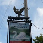
- Address
- Swan with Two Nicks, Sharnbrook
- Website
- https://www.facebook.com/swanwith2nicks/
Charles Wells local style village pub offering bar meals and Eagle ale. Probably the most striking part of this pub is its name, The Swan with Two Nicks. Swans have traditionally been the property of the reigning Monarch. However, in the 16th century, Queen Elizabeth I granted the right to ownership of some swans to various guilds and influential families including the Worshipful Company of Vintners. In order to be able to tell which Swan belonged to whom, it was decided that Vintners' swans should have their beaks marked with two notches, or nicks. Thus the name depicts a swan under the ownership of the Vinters.
The only ale on offer here was Charles Wells Eagle. A local, who was sitting at the bar when we arrived, told me that they had tried other ales but they would not sell and ended up throwing most away!. Where I grew up, a few miles north of here, Charles Wells beers were either loved or hated there was no half-way. In my younger years I thoroughly hated them! It wasn't until the 1990s that I started to enjoy drinking their beers, but by then the brewery had switched from using their own well to the water mains as a water source. Maybe it is this that has made their beer more agreeable with my palate. Certainly this pint of Eagle was refreshing!
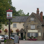
Muntjac, Harrold View in OS Map | View in Google Map
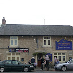
- Address
- Muntjac, Harrold
- Website
- www.themuntjac.co.uk/
This 17th Century Coaching Inn formerly known as the Globe, is now a Freehouse with accompanying Indian restaurant offering both sitdown and take-away meals. A variety of guest ales are on offer in this busy village local. En-suite accommodation is available.
Not quite the old local that I remember when it was called the Globe but I cant fault this pub for its selection of ales including Wooden Hand Brewery's Pirate Gold. There were three on offer in total and all most excellent. We had a meal in the accompanying Indian restaurant and this was excellent food and very reasonably priced too. The restaurant area is quite small and it took some time before a table became available which meant having to sample more of their ale! On one of the walls in the restaurant was a print of "The Singing Butler" by Jack Vettriano which was rather curious and thought provoking. I couldn't help but think I have seen this painting somewhere before but cannot recall where.
Features
HarroldView in OS Map | View in Google Map
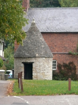
This ancient attractive village, consists of a mixture of old stone houses and thatched cottages together with a village green, mature trees and a bridge with medieval origins. On the green there is a Lock-up built in 1824 which was used to house criminals until they could be dispatched to Bedford, it is one of only about three hundred surviving in the country. The Butter Market is also situated on the green and was built between 1710-20 and is a reminder that Harrold had its own market charter. A horse fair was also held regularly, and on these market days villagers could sell beer without licence by displaying a green bough by their door, this custom known as 'tapping' was stopped in 1858.
References
OdellView in OS Map | View in Google Map
The name of Odell is derived from saxon times when it was known as Woadhull on account of the amount of woad, a plant used for its blue dying properties, that was grown in the area. A Saxon stronghold stood on the banks of the river and when this fell to the Normans, the land was granted to Walter the Fleming who erected a motte and bailey castle. By Tudor times the estate was in ruins and in 1633 William Alston purchased and restored the entire estate. This remained as the Alston family home until 1931 when the property was gutted by fire. Today, a modern building stands on the site.
Dramas from the past include that of Reverend Peter Baulkley, who in 1635 rebelled against established Church rule under Archbishop Laud, and led his congregation on a voyage to America, where they founded the town of Concord, Massachusetts.
Probably the most famous story of this hamlet happened in the 1700's and concerns a local squire by the name of Sir Rowland Alston who owned most of the farmland around the village, renting portions of it to tenants from which he lived well on the profits. It is said he was a most wicked of squires who drank and ate too much, picked fights, gambled and neglected and terrorised his tenants. Then one stormy night, a tall stranger riding a black stallion called upon Sir Rowland. What happened between Sir Rowland and the stranger as they conducted their business behind closed doors will never be known but Sir Rowland rushed out from the meeting, jumped onto the strangers stallion and headed for the church with the stranger in hasty pursuit. The next day the villagers made their way to the church in search of the squire and found the hefty door locked and bolted from the inside and five burn marks in the shape of fingerprints marked on the stone porch. Eventually a window was prised open and a young lad pushed through the gap. He was the first to witness Sir Rolands dead body, its face contorted into a look of sheer terror. The story soon got around that Sir Roland had sold his soul to the devil whom had come to claim his debt and he had headed to the church in desperation to be on hallowed ground.
From that date his ghostly spectre sat astride a ghostly black stallion would ride into the hall of his family home leaving hoof prints in the flagstones. This became such an occurrence that an exorcism was performed by twelve clergymen all with bell, book and candle and his spirit consigned to the village pond. Villagers who passed that way were said to be able to hear him snoring. However his ghost did not rest here as local legend states that once every one hundred years his ghost rises and repeats his frantic ride to escape the Devil and gallops down the bridleway towards the church. The next occurrence of this ghostly event is said to be in 2044. The devils imprints on the stonework have unfortunately been removed by an over zealous builder during maintenance work.
References
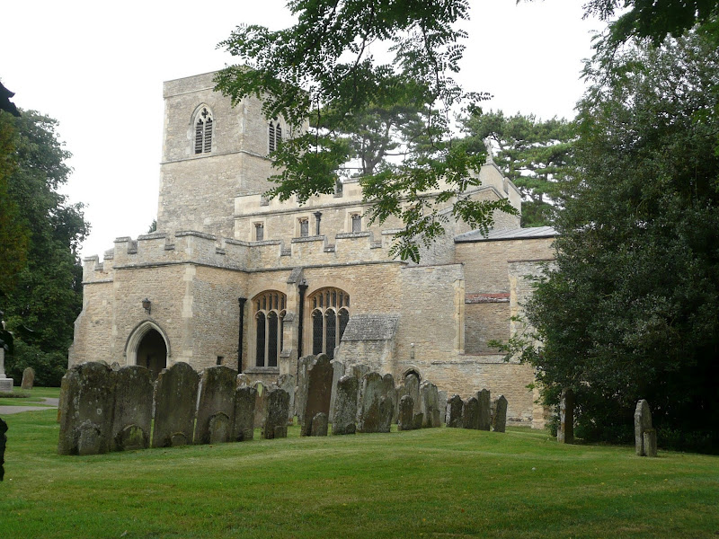
St Mary the Virgin Church, StevingtonView in OS Map | View in Google Map
A church has stood on the site of the present church of St Mary the Virgin since 880 AD and the tower still survives from this period with additions to the building in 1480 and 1872. Local legend states that the body of Napoleon Bonaparte's valet from his exile on St Helena is buried in the churchyard, however, parish records are incomplete and the brick vault that is said to contain the remains is too weathered for identification.
In the boundary wall of the churchyard, to the north of the church, is a spring of clear water known as Holywell. This spring is said to never freeze and never fail in times of drought. During the middle ages this became a site of pilgrimage as the spring was said to have miraculous powers to heal eye ailments.
The lane by the church is said to be haunted by a shadowy figure dressed in a large hat and cape. The identity of this figure is unknown.
References
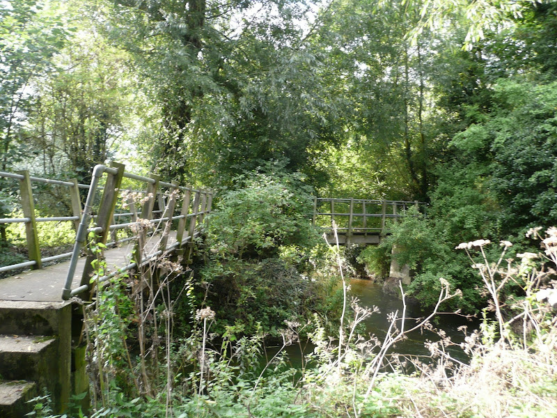
Pinchmill IslandsView in OS Map | View in Google Map
Between Radwell and Sharnbrook the River Ouse branches into numerous channels creating a natural miniature archipelago whose islands are covered with a dense mass of undergrowth and trees. These islands are commonly known as the Pinchmill Islands and the Ouse Valley Way navigates across them using six wooden footbridges that link them together. The name Pinch mill, sometimes referred to as Pynch Mylne, is thought to come from a former water mill which had stood on the islands. There is documented evidence of this mill going back to 1278 in the Hundred Rolls of the hundred of Wilye, referring to it as Molendinium de Pynches. It has been suggested that the Mill may well have been owned by a small manor or farm named Pynche lying within the parish of Sharnbrook or Felmersham though an alternative explanation is that the mill was built at a natural narrowing, or pinch, in the river. The mill was eventually demolished in 1880 after the water courses had silted up, and a new cut dug out to allow river traffic to pass from Sharnbrook water to the Felmersham reaches. Today the islands form a natural water playground for local children.
References
Harrold and Odell Country ParkView in OS Map | View in Google Map
Harrold and Odell country park occupies some 144 acres of former sand and gravel quarries between the two villages of Harrold and Odell. The main features are two lakes named Grebe Lake and the smaller Kingfisher Water. Alongside these are river meadows, marsh, woodland and the River Ouse which presents a picturesque scenery of wildlife and fauna. Herons, Canada geese and mute swans are frequently seen with rarer visits from Bitterns and Little Egrets. Foxes, weasels, shrews and rabbits abound together with bats at dusk and a family of otters close to Grebe Lake. Frogs, toads and newts can be seen in the wetlands and grass snakes can be seen in summer. There are numerous walks and trails including a section of the Ouse Valley Way which runs the length of the park.
References

Gallery
Below are a selection of images taken from from the photo album for this walk. Feel free to browse through these or click on an image to view a larger version in the Gallery.


Summary of Document Changes
Last Updated: 2021-12-07
Bedfordshire, Distance:long, Features:Churches and abbeys, Features:Folklore, Features:Local History, full-detail, OSmap:208, Ouse Valley Way, Riverside Walk


0 comments:
Post a Comment