Exploring the Suffolk Coast and Heaths area of Oustanding Natural Beauty around Aldeburgh
|
Tuesday 10 December 2019
|
No comments |
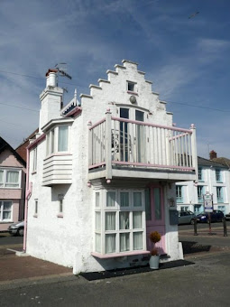
![]()

A 12.5 mile walk between Aldringham and Aldeburgh through the Suffolk Coastal Area of Outstanding Natural Beauty
There is a variety of differing scenery along this route, gentle hills around Aldringham, boardwalks across the marshes at The Fens, a walk along the old Aldeburgh railway and an estuary walk along river defences of the Alde. With such treasures as the pretty little church at Aldringham, tucked away in the trees and away from civilisation and the magnificent church of St Peter and St Paul at Aldeburgh, there is plenty to see and explore.
Exploring the Suffolk Coast and Heaths AONB around Aldeburgh - Essential Information
Walk Statistics:
- Start location: Aldringham
- Distance: miles ( km)
- Total Gain: ft ( metre)
- Total Descent: ft ( metre)
- Min Height: ft ( metre)
- Max Height: ft ( metre)
- Walk Time:
- Walk type: Circular
- Walk Grade: Easy
- Terrain:
Maps:
The following maps and services can assist in navigating this route. There are links to printed maps and links to downloadable GPX route data for importing into navigational software and apps.
- Ordnance Survey Explorer Map
- OS Explorer 212 - Woodbridge & Saxmundham
- GPX Route File
Route Verification Details
- Date of Walk: 2021-03-06
- Walk Time: 09:30 to 15:30
- Walkers: Griffmonster, Kat
- Weather Conditions: Bright and sunny spring day with a cool southerly breeze
Walk Notes
The walk can be extended to start and end at Leiston with a simple addition to the route
On this occasion there appeared to be an organised hike along the Sandlings. We first encountered a group of youngsters with full gear including camping equipment walking along the Sandlings near North Warren. We then encountered another group looking decidedly lost just off the trail near the radio mast before Aldringham. They sauntered off down a track not marked on the map and certainly not a public right of way. As this happened, another group walked through on the Sandlings, the other side of the field and soon attracted their attention, and off they traipsed along the field edge to rejoin the correct route. Methinks some map reading exercises are needed!
Directions
Leiston to Aldringham
To get to and from the walk from Leiston, head out of town on Haylings Road. Just past Fridays Orchard, on the left there is a footpath that leads round to Goldings Lane. Cross this road and a path cuts diagonally across the field and then runs parallel with the road into Aldringham.
Aldringham to Aldeburgh Circular
At Aldringham head south on the B1122 from the Parrot and Punchbowl pub to the first bungalow on the
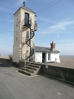
At the edge of Aldeburgh take the path on the left through the caravan park. This leads through the site on a tarmaced road. Pass the reception and when you get to the toilet block another site road joins on the right, turn back on yourself up this for a few yards and there is a metal gate to the public road with a footpath to the church on the opposite side. Continue through the church grounds and onto the road, turn left and walk down to the sea front. Turn right and follow Crag Path. Continue until you reach the old Lookout with the external spiral staircase on the beach. On the right there is an alleyway through to the High Street, take this and turn left on the High Street. The White Hart is a few yards down the road.
Continue along the road until it turns to a gravel track to the boatyard. On the left, a path along the river defences is marked with a general waymarker. Take this path and keep to the defences, past the first and second footpath markers pointing down across the marshes. The path will follow the bends in the river until it is facing north-east. Once you meet a set of wooden steps with a handrail that leads onto a footpath across the marshes then it is time to head inland. There is no marker here but if you attempt to carry a on along the defences the path tapers and eventually ends. Follow the worn path across the meadows and up through the allotments to a paved path. Turn left and walk through Kings Meadow recreation ground and onto the main A1094. Turn left and follow the road out of town.
Just before the last houses on the right there is a broad track waymarked with the Suffolk Coast Footpath blue and yellow sign. Walk down here for 10 yards and an opening on the left will lead onto a footpath which goes across the golf course. Keep to the footpath which is clearly marked across the course and then on between the woods at the top of the hill. Here it joins a farm track. Take notice that as the track bends to the right there is a gate on the left where the footpath will lead diagonally through the trees and through another gate on the opposite side. Follow the field edge for 50 yards and then cut diagonally across the fields heading for the radio mast. Here it rejoins the Sandlings. Turn left and follow the Sandlings for the short distance to Round Covert woods where a track leads down the side of the woods. 2/3rds of the way down the track bends to the right. Keep with the track to the first field boundary and keep on the woods side of this field boundary. When the path meets Fitche's Lane which is no more than a footpath itself, turn right and almost immediately left to follow a footpath through the heavily treed heathland to Aldringham. The path joins a road which leads back down into the village just down form where the walk started.

Pubs
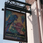
The Parrot, Aldringham View in OS Map | View in Google Map
- Address
- Aldeburgh Road, Aldringham
- Website
- parrotandpunchbowl.co.uk/
Taken over in 2017 the pub was renamed simply The Parrot
from the more distinctive name of The Parrot and Punchbowl
which, despite its quirky modern moniker, had existed for many centuries. The pub is currently owned by the management team of the nearby Thorpeness Dolphin pub.
The establishment dates back to the 16th century and its more familiar original name was adopted in 1604 when the Kemp family took over the premises. Throughout the ages the pub has been linked to the infamous smuggling stories that surround the area. It was the holding place of smuggled stock with the last recorded seizure being 300 tubs of gin. A tunnel is reputed to lead from the grounds of the inn to Aldringham church. You may also notice a flat stone to the left of the main door of the pub. Once a mounting block, folklore has it that a poor unfortunate shepherd met an untimely death there, his skull later found in a pond that used to be at the back of the property.
Excellent food and ales on offer including Adnams and Woodfordes Wherry. Not open Sunday evenings.
White Hart, Aldeburgh View in OS Map | View in Google Map
- Address
- High Street, Aldeburgh
- Website
- www.whitehartaldeburgh.co.uk/
Plenty of nautical memorabilia adorns this single wood panelled bar which used to be the public reading room. Next door to the town's renowned fish and chip shop and a few yards from the beach it is popular with both tourists and many locals.
A Grade II listed building and former chapel room which is now a sparse single roomed alehouse with benches in front of the building. Dont be put off by this basic appearance as this is the best pub in town for ale with a range of Adnams plus guest ales.
In my opinion this is the best alehouse in Aldeburgh. It is very basic, you are fined if you use a mobile phone and there is little in the way of food. However, there are always guest ales available and on this occasion we sampled a pint of Preservation ale from Castle rock Brewery in Nottingham, a very hoppy and well balanced bitter.
Features
St Andrews Church, AldringhamView in OS Map | View in Google Map
Built in the 12th century by Ranulph de Glanville and part of the possessions of Leiston Abbey, this small village church is tucked away on the heathland and some distance from the village. It used to have a and a thatched roof and a tower, which was built in the 15th century, but this structure was in ruins by the mid 1800's and was demolished when the church was completely refurbished by the Victorians.
References
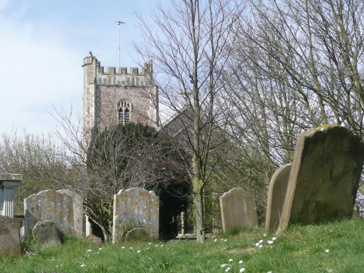
St Peter and St Paul Church, AldeburghView in OS Map | View in Google Map
This traditional East Anglian flint church dates from the 17th century though the tower is 14th century. Most notable features are the Benjamin Britten Memorial Window, which depicts three of Britten`s best known operas; a bust of the Aldeburgh born poet and clergyman Gorge Crabbe and the royal arms of King Charles II. Benjamin Britten and his partner, the singer Peter Pears, are buried in the churchyard extension, and nearby is their friend Imogen Holst, and at the front of the building is buried George Crabbe.
References
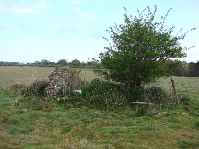
Hazelwood Chapel RuinsView in OS Map | View in Google Map
Approximately 2 miles out of Aldeburgh in a field between the Leiston and Saxmundham roads is the position where a former Hazelwood chapel stood. Today this land is part of a farmers field with strong messages to walkers warning them of trespass if they continue along the track after the footpath diverges. It has been stated that human remains and coins have been found in this field though little else is known of this former chapel.
AldeburghView in OS Map | View in Google Map
The name Alde Burgh means "old fort" and it is thought to date from Roman times. Most of the town has been lost to the sea over the years and to give an idea of this, the Moot Hall which presently stands on the sea front was once the centre of the town. The main industry during the middle ages was ship building and the port produced Sir Francis Drakes ships Greyhound and Pelican, which was later renamed to the better known Golden Hind. Ship building declined when the Alde silted up and the town became a small fishing village until the railway was built in the 19th century which popularised the place as a seaside resort. Today it is still a fashionable resort with rows of fishing shacks offering freshly caught fish and curious buildings and architecture.
References
Leiston Manor GibbetView in OS Map | View in Google Map
In 1606, there was a tragedy in the Browne family. Agnes the wife of John Browne son or grandson of Robert Browne, murdered her husband ; and, Suckling says that one Peter their servant was gibbeted for the crime. What happened to Agnes we do not know; we have depositions, taken upon an enquiry as to the King's right to her goods, which shows that she had been condemned as a felon. The gibbet on which Peter was executed was the manorial gibbet of the manor of Leiston, the site of which according to a perambulation of that manor, made in 1620, may be found :—by following "the brook between Thorpe and Hazelwood manors, until you come unto Friday Market Heath, and then, leaving the water-course, following the hedge south-west until you come next a green way," which will be "beyond the gibbet."
An in depth piece of research was undertaken to determine the location of LEiston Gibbet and this was documented on this site at In Search of Leiston Gibbet. It is highly recommended that this is read for those who are interested in this subject.
References
Links and Bibliography:
Gallery
Below are a selection of images taken from from the photo album for this walk. Feel free to browse through these or click on an image to view a larger version in the Gallery.


Summary of Document Changes
Last Updated: 2021-12-07
Circular Walk, Distance:long, Features:Churches and abbeys, Features:Local History, Features:Ruins, full-detail, OSmap:212, Suffolk


0 comments:
Post a Comment