The Icknield Way - Linton to Herringswell
|
Sunday 30 December 2018
|
No comments |
![]()
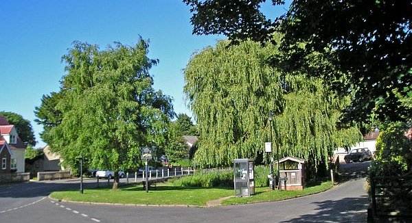
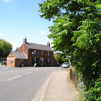
A 26 mile walk along the Icknield Way between Linton and Herringswell
This section of the Icknield Way passes through some idyllic and typical English landscapes where village greens, thatched cottages and traditional country pubs nestle in with babbling brooks and the gently swaying fields of barley that cover the rolling hills. It is a sheer pleasure to wander through. The only issue with this walk is the lack of accommodation unless one makes diversions away from the trail.
The Icknield Way - Linton to Herringswell - Essential Information
Walk Statistics:
- Start location: Hinton
- End location: Woods south of Herringswell
- Distance: miles ( km)
- Total Gain: ft ( metre)
- Total Descent: ft ( metre)
- Min Height: ft ( metre)
- Max Height: ft ( metre)
- Walk Time:
- Walk type: Linear
- Walk Grade: Easy
- Terrain:
Maps:
The following maps and services can assist in navigating this route. There are links to printed maps and links to downloadable GPX route data for importing into navigational software and apps.
- Ordnance Survey Explorer Map
- OS Explorer 209 - Cambridge
- Ordnance Survey Explorer Map
- OS Explorer 210 - Newmarket & Haverhill
- GPX Route File
Accommodation:
Herringswell WoodlandWild campView in OS Map | View in Google Map
- Description
- Wild camp in woods south of Herringswell
Route Verification Details
- Date of Walk: 2009-06-22
- Walk Time: 08:30 to 21:30
- Walkers: Griffmonster
- Weather Conditions: Clear blue summer skies, hot
Walk Notes
From the research done in the weeks prior to setting out on the Icknield Way I had come to the conclusion that I would need to wild camp on this section. That was not a decision taken lightly but something deduced from other hikers attempting to walk the extensive section between Linton and the end of the trail at Knetteshall Heath. It is true that wild camping is not actually legal in England but given a lack of accommodation on route and no alternatives then a discreet, out of sight location is the last resort. Providing one leaves no mess, no litter then what harm can be done? In my book one has to leave any site as if you had never been there.
Therefore with this in mind, I started out the day in leisurely mood without any clear destination and with the idea of just getting as far as I could by the end of the day! After a good mornings walk I stopped off at the Bull at Burrough Green and it was such a pleasant experience sitting there in the sun that I spent a full hour lazing in that pub garden. This set the trend for the day, stopping off at The Marquis of Granby in Stetchworth to sit and watch the world go by, then lazing on the green at Cheveley before continuing with pub stops at Ashley, Dulham and Gazeley. The most disappointing part of the pub crawl was the fact that all the inns apart from the Affleck Arms at Dulham were Greene King houses. This brewery appears to have a virtual monopoly in the area. The Affleck Arms was a real treat though, this is just off route but well worth searching out and I thoroughly recommend it. Excellent ale, excellent company and excellent old pub.
This was the day of the kissing gate - the previous day had been all about styles in all manner of construction and glory and now it was the day of the kissing gate. Although their construction was similar throughout they became the accustomed entrance and exit to every boundary and every new footpath. It is strange how the method of footpath restriction changes and I can only put this down to the crossing of the county borders.
This trail also led through some excellent landscapes that portrayed typical English countryside, the sort of scenes that would aptly fit on chocolate box tops and jigsaw puzzle scenes. Vast open landscapes of gently rolling hills; Fields of gently waving barley bowing majestically in the breezes under deep blue skies; Traditional old pubs and thatched cottages adorning village greens; Babbling brooks and streams and villages full of tumbledown cottages. This truly was the heart of England.
There was obviously a lot of money in these villages and no doubt the inhabitants merely commuted to their senior jobs in the affluent centres of commerce such as Cambridge or were connected to the horse racing industry with Newmarket also being close by. Indeed there was much to connect to such an industry with a multitude of horse paddocks along the route. This was even more evident in the Crown pub in Ashley where at 6ft tall I was positively a giant amongst the clientel. On entering the establishment I witnessed a group of men sat on barstools around the bar. These were not so much as bar stools as height compensators for when one of their group jumped down he reduced his height by a considerable amount and scurried off to the toilets like a small child. These were obviously all professional jockeys.
Maybe it was the fact of incurring constant refreshment stops but by the end of the day I had covered well over 25 miles and was still feeling as fresh as a daisy. The only reason that prevented pursuing more miles was the failing evening light. I had started looking for suitable places to pitch after the village of Dulham and this was after enquiring of the possibility of a room for the night at the Affleck Arms. Unfortunately the rooms were all taken, the last lodging being reserved just a matter of hours earlier.
The the light well and truly fading as I traipsed along a track that led through the woods near Herringswell. This woodland looked quite a suitable location with plenty of space between the trees and the ground covered in soft forest litter. I waited for a dog walker to wander out of sight before nipping into the woodland and springing up the tent. Once cleared of the fallen twigs and branches I found the ground to be very soft and comfortable, in fact I would say you could not have got a better bedding to sleep upon. No sooner had I pitched than the light was gone and it was pitch black. I couldn't see a thing in the tent, I have never known such complete darkness.
I attempted to drift into sleep but there is always the nagging feeling that I may get disturbed from some angry land owner. An animal came and sniffed at the tent then went away. Then I heard distant barking and then another bark called back its sound distinctively closer. This continued every few seconds. At first I thought it was dogs from the nearby village but it was soon quite apparent that the noises were emanating from the forest. I convinced myself that this country does not have wolves or any other nasty creatures that eat humans and tried to ignore the noise. It carried on until I eventually drifted into sleep. Later, on my expeditions, I was informed that the barking was muntjac deer - they sound the same as a dogs bark and it is quite common to hear them calling to each other in woodland.
Directions
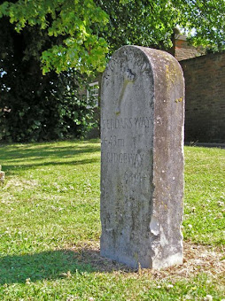
From Linton High Street turn down Meadow Lane on the left as the High Street bears to the right. After 150 yards there will be a waymarker on the right, follow this through the built up area and finally the path will lead up the hill to the water tower from where a good view of Linton is to be had. The trail now leads via a roman road through to Balsham where there is an Icknield Way milestone declaring 'Peddars Way 43 miles' and 'Ridgeway 63 miles'. A broad farm track now leads to Willingham Green and down into Brinkley from where a path across the fields takes you to Burrough Green. The path continues down by the side of the Bull public house, this leads across a series of paddocked fields through to Stetchworth. Walk along the road into the village and the path is located opposite the Marquis of Granby public house and leads across a housing estate road and down the back of a series of houses before going downhill to Devils Dyke. Continue following the paths through some very typical english contryside and paddocks, past Woodditton, through Cheveley and onto Ashley. Follow the Gazeley road out of Ashley downhill to where it meets the river Kennet, turn right and walk through the meadows to Dalham. At Dalham village turn left and head for the church. A path turns right and leads through woodland and across fields to Gazeley where it follows road out of the village towards the A14. There is a path through the fields just prior to reaching the A14 but this rejoins the road to go under the dual carriageway. There is an industrial area on the left, walk through this and a track then leads up through woodland towards Herringswell.

Pubs
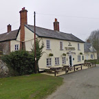
The Bull, Burrough Green View in OS Map | View in Google Map
- Address
- The Green, Burrough Green
- Website
- www.burroughgreen.com/Pub/pub_home.htm
Lovely little village pub set back from the road just off from the village green serving Greene King ales. There is a garden in front of the pub. Food served.
Sitting on the benches in front of the pub watching the world go by was most excellent waste of an hour. Had a pint of Greene Kings Delgardos Heros, a one-off brew to mark the occasion of the rugby world cup.
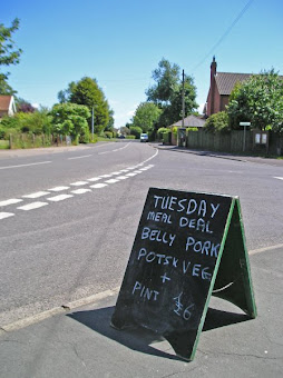
The Marquis of Granby , Stetchworth View in OS Map | View in Google Map
- Address
- High Street, Stetchworth
Greene King pub on the junction of the main roads through Stetchworth. Home cooked food.
I arrived as the pub was about to close. The A-board outside advertised Belly Pork with Potatoes and Veg plus a beer for £6 - had I been earlier I would have certainly gone for this excellent deal.
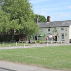
The Crown, Ashley View in OS Map | View in Google Map

- Address
- Newmarket Road, Ashley
- Website
- www.ashleyvillage.org.uk/the-crown-pub/
This pub dates from at least the 1700's when records show that it was owned by a James Langley. In 1866 it was put to auction with the details recorded as a newly erected brick, stone and tile built carriage house, a loose box, stabling for six horses, a small barn, a cart lodge and a range of piggeries plus a small yard. The property finally passed to Greene King ownership in 1890 to which it has remained ever since.
When I entered the pub I appeared to be the only person over 5ft tall. It then dawned upon me that the this was close to Newmarket and was probably a popular haunt for jockeys. Standard Greene King ales.
The Affleck Arms, Dalham View in OS Map | View in Google Map

- Address
- Brookside, Dalham
- Website
- dalham.com/new/?page_id=88
Charming thatched village pub dating from the 16th century. The pub's name is derived from the Affleck family whom owned the estate that it was built upon. Formerly a Greene King house, the pub is now free of tie and regularly has four guest ales on offer. Accommodation and food available. Reputedly haunted by a Grey Lady.
Very friendly and popular and both the choice of ale and the ale itself was most excellent. IT wasnt long before conversatio sparked up and it soon became apparant that I had missed out on an available room by a mere hour. Well worth searching out and highly recommended.
The Chequers, Gazeley View in OS Map | View in Google Map
- Address
- The Chequers, Gazeley
- Website
- https://www.munsons.co.uk/contact-munsons-brewery/
Village pub said to date from the 16th century that was a Greene King house up until 2018. It has subsequently been taken over by an independent owner and is brewing their own beer under the Munsons Brewery name.
On entering the pub I felt distinctly out of place. That moment when all eyes focus on the stranger walking through the door. I was served with minimal conversation. All eyes kept a cautious focus on me, the stranger. I supped up quickly and made my way.
Features
Via DevanaView in OS Map | View in Google Map
Between Hinton and Balsham the Icknield Way joins a short section of Via Devana, an old Roman Road linking Colchester with Chester. The name Via Devana was coined in 1750 by Charles Mason, a Cambridge geology professor. The name reflects the Roman name for Chester, Deva. An information board details the natural flora and fauna along this section.
BalshamView in OS Map | View in Google Map
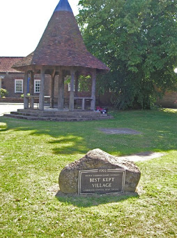
Originally settled during Saxon times, the village of Balsham was totally destroyed by Viking raiders in 1010. A sign on the village green commemorates the sole survivor of the attack who escaped by hiding in the parish church. The church of The Holy Trinity is an impressive building, the bell tower dates from the 13th century, whilst the chancel dates from the early 14th century.
Devils Ditch (Devils Dyke)View in OS Map | View in Google Map
Devil's Dyke is generally assumed to be an Anglo-Saxon earthwork which starts on flat farmland and then passes to the west of Newmarket and runs along the edge of the July Course at Newmarket Racecourse before rising gently to an altitude of 100m as it reaches the wooded hills around Woodditton. It crosses the Icknield Way just to the northeast of Stetchworth. In places it is 20 feet wide and 30 feet deep and is thought to have been used to demarcate the boundary of a tribe's influence as well as a barrier to the British tribes to the west.
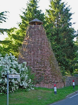
DalhamView in OS Map | View in Google Map
Dalham is a pretty liitle village full of thatched cottages that sits on the River Kennet. Dalham Malting Kiln is a curious feature sitting on the roadside in Dalham. The former malting kiln is listed in the Register of Historic Buildings and was built in the early Victorian era. There is an inscription on one of the hand-made bricks which reads 'J.D 1846', though it may have been constructed significantly earlier than this as the Enclosure Map of 1820 indicates it was then owned by William Ruffell, who also built and owned the windmill on Stores Hill. Dalham Hall is a Grade 2 listed country house and 33000-acre estate. There is no recorded date as to when the Hall was first constructed though there are records dating back to 1313. Thomas Stuteville bought the estate in 1417, when it is presumed that he rebuilt the house and his family occupied the residence until it was bought by Gilbert Dolben in 1697. There have been numerous other owneres including Cecil Rhodes, although he passed away before taking residence. The hall and its associated stud are currently owned by the ruler of Dubai, Sheikh Mohammed bin Rashid Al Maktoum.

Links and Bibliography:
Gallery
Below are a selection of images taken from from the photo album for this walk. Feel free to browse through these or click on an image to view a larger version in the Gallery.


Summary of Document Changes
Last Updated: 2021-12-07
Cambridgeshire, Distance:Hike, Features:Local History, full-detail, Icknield Way, OSmap:209, OSmap:210, Suffolk


0 comments:
Post a Comment