Angles Way - Belton to Oulton Broad
|
Tuesday 10 December 2019
|
1 comment |
![]()
A 14 mile walk along the Angles Way between Belton and Oulton Broad, crossing the border from Norfolk to Suffolk
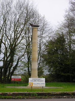
The Angles Way roughly follows the River Waveney down to Oulton Broad from Belton although there are very few locations where the river can be viewed. Most of the route is across fields, along country lanes and through little bits of woodland. It is a pleasant full afternoons walk with a couple of pubs en route for refreshment. The main place of interest is Somerleyton, named after a peace loving Viking, Sumarlithi, who arrived in the 10th century. It is now a sleepy little village, famed for being the home to Christopher Cockerell, the inventor of the hovercraft, but more renowned for its connection with Gradabor, a giant who once ransacked the area. Some say his ghost still returns to re-enact this destruction.
In search of the Somerleyton Giant. - Essential Information
Walk Statistics:
- Start location: Wild Duck Camp Site, Belton
- End location: Lowestoft
- Distance: miles ( km)
- Total Gain: ft ( metre)
- Total Descent: ft ( metre)
- Min Height: ft ( metre)
- Max Height: ft ( metre)
- Walk Time:
- Walk type: Linear
- Walk Grade: Easy
- Terrain:
Maps:
The following maps and services can assist in navigating this route. There are links to printed maps and links to downloadable GPX route data for importing into navigational software and apps.
- Ordnance Survey Explorer Map
- OS Explorer OL40 - The Broads
- GPX Route File
Accommodation:
Wild Duck Camp SiteView in OS Map | View in Google Map
- Website
- https://www.haven.com/parks/norfolk/wild-duck/
- Description
- Wild Duck Camp Site (part of Haven Holidays), Belton
Transport:
Details of public transport that is required for the walk
First Group - Bus Service
- Service Details
- X1 - First group bus service 1 Lowestoft to Great Yarmouth
- Timetable
- Available here
First Group - Bus Service
- Service Details
- 7 - First group bus service 7 Great Yarmouth to Belton
- Timetable
- Available here
Route Verification Details
- Date of Walk: 2010-04-30
- Walk Time: 11:00 to 17:00
- Walkers: Griffmonster, Kat
- Weather Conditions: After some very persistent rain in the morning, the afternoon slowly brightened up. Cool.
Walk Notes
For this walk we camped over at the Wild Duck campsite in Belton and was due to set off first thing in the morning. However, come the morning rain was teeming down in torrents. It is a good feeling hiding under canvas when its raining, a feeling of protective isolation. Even so we did not want to sacrifice the day to listening to the pitter patter of rain on canvas and it ws a disappointment that it was raining so heavily. We stuck it out until 11 o'clock when the downpour eased and then ventured forth with waterproofs and determined spirit. This was a good move as the afternoon brightened up with the result of a very pleasant afternoons walk.
It was unfortunate that when we arrived at Outlon Broad we could find no alternative but to walk through the busy town streets to Lowestoft in order to get the bus back to Great Yarmouth.
Although not part of the walk, an interesting development occurred in the Wild Duck entertainment and food building that evening. This is basically a bar come restaurant and we decided to have a look in there rather than pop to the local pub. As expected, it was a typical holiday camp venue geared towards family based clientel. Now, unconnected with this is the fact that as part of my employment I am have to meet clients within London. This usually happens upon a Wednesday and this coincides with a fire alarm practice. During the meeting we stop all discussion and ride out the loud messages and sirens which are very distinctive but nonetheless annoying due to the interruption of business. Anyway, back to the Wild Duck venue, that evening we ordered a curry which they served from hotplates. We chose our dishes and retired to a table to consume the food. Within the first mouthfuls the fire alarm went off which was pretty much the same as I have come to experience in the London office. Therefore, instinctively I stopped conversation and waited for the messages and sirens to cease. Unbeknown to me the rest of the hall was evacuating and it was a minute or two before I realised this was not a rehearsal and put the curry aside to find the nearest exit. This only goes to highlight the 'cry wolf' effect that fire alarm rehearsals can have. Those precious couple of minutes could in certain circumstances have dire consequences and it does make me wonder if these policies are just Health and Safety overkill made up by bureaucrats in offices. As it happened, this was a small fire in the kitchens which was promptly dealt with.
Directions
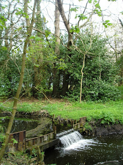
The Angles Way passes the entrance to the Wild Duck campsite and caravan park and using lanes continues through to Fritton. The route is well marked out with the distinctive Angles Way waymarkers. This also is the route of the Waveney Way though there are no markers to that effect. At Fritton it cuts across the land using footpaths and little used roads to Somerleyton. A footpath through the wooded areas down by the Waveney then leads through to Oulton Broad.
Belton to Oulton Broad
The path passes the entrance to the Wild Duck campsite and caravan park. A hundred yards up the road the distinctive Angles Way waymarkers direct you down a track called Sandy Lane. Continue down here, past Caldecotte Hall until there is a waymarked footpath on the left. This brings you out on the main A143 where, turning left, there is a couple of hundred yards of road walking before crossing the road and taking a track down to a back-road. Turn left and this comes back out onto the A143 on which you need to remain through Fritton until there is a footpath on the left. This leads through a wooded area at the end of the lakes and on up to a country lane. Turn left and follow the road until there are woods on the right. A track leads through the woods then crosses a road and onto a farm track. At the end of this turn right and the track passes Ashby church before meeting another track which, turning right, leads down to the Somerleyton Road. Continue into Somerleyton and head for the station. where the road turns back on itself up to a t-junction. Turn right and follow the lane and footpath through the wooded areas all the way through to Oulton village where it comes out by the Church. Turn right and follow the lane round the back of the houses and over the railway into a housing estate. Keep following the roads through to Oulton broad North railway station.
Oulton Broad to Lowestoft
There is no easy way into Lowestoft. This is an urban area and entails much road-walking. Head down the A1117 to the roundabout, go straight over, and continue to the next roundabout. Once again go straight over and follow the road into the town centre.
Pubs
Decoy Tavern, Fritton View in OS Map | View in Google Map
- Address
- Decoy Tavern, Fritton
Traditional pub on the main road with a friendly welcome and nice beer including Woodfordes ales. Food served
Very friendly traditional pub with snacks on the bartop and conversation from the barstaff. A fine pint of Woodfordes Wherry.
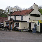
Dukes Head, Somerleyton View in OS Map | View in Google Map

- Address
- Dukes Head, Somerleyton
- Website
- https://www.somerleyton.co.uk/somerleyton-hall/the-dukes-head/
Minimalist gastropub on Slug’s Lane in Somerleyton overlooking the river Waveney. Food is locally sourced and ale is from local breweries including Green Jack, Woodfordes and Adnams.
Busy Sunday lunchtime in this modern looking pub. Nice pint of Green Jack.
Features
Somerleyton GiantView in OS Map | View in Google Map
Somerleyton was once the hunting area of a giant who went by the name of Gradabor. Gradabor was Blunderbore's non-identical twin and was 10 times the size and 20 times as nasty as his sibling. If you have never heard of Blunderbore, he is the infamous giant of Cornish folklore who was the inspiration for Jack and the Beanstalk. The story goes that a certain Somerleyton chap decided that he could destroy Gradabor and suitably prepared a big pit and filled it with spikes which he expected the giant to fall into. However Gadabor caught the man in the act of digging the pit and rightly assumed it to be trap, so picked the man up between his fingers and squeezed him to death, his blood raining down upon the earth below. There is no record of what become of Gradabor but it is claimed that on the evening of 17th July he returns for one troublesome night, knocking down fences, sitting on churches and feasting on cows. Then, on the 19th November, the would be assassin's blood is said to rain down on the fields from the sky.
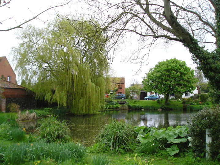
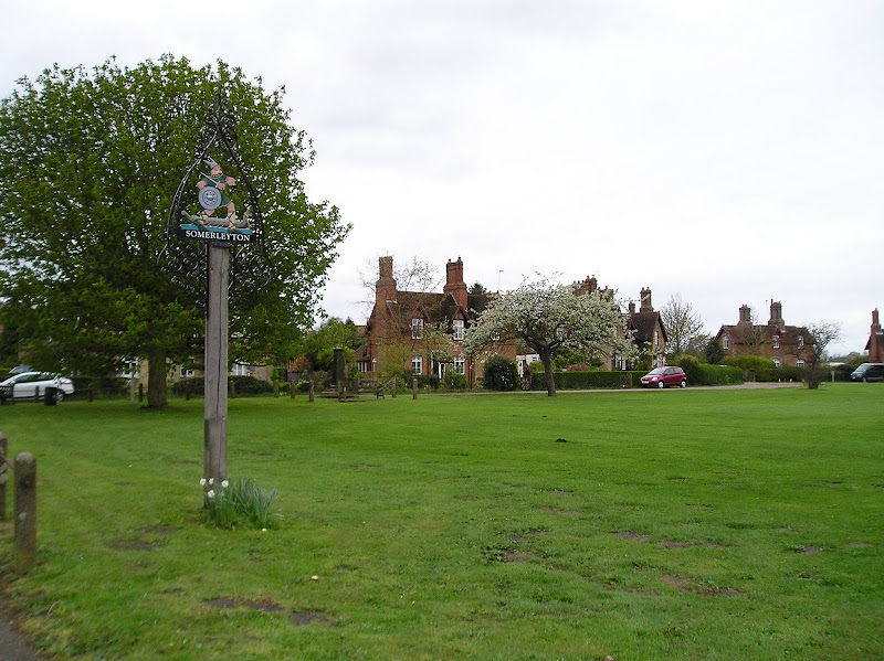
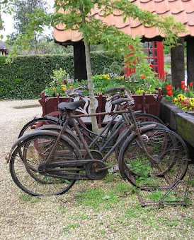
Somerleyton VillageView in OS Map | View in Google Map
Somerleyton is a village full of curiosity. It has a village pond, a post office with old bicycles standing outside as ornamentation, a village green with a hand-pump and a petrol station that, although modern, looks as if it is from the distant past. Somerleyton was also the home of Christopher Cockerell the inventor of the hovercraft who used the resources of 'Ripplecraft', a boat hire company for the Norfolk Broads, to create his unique work. There is a memorial to him which stands beside the main road (B1074) between St Olaves and Lowestoft.
References
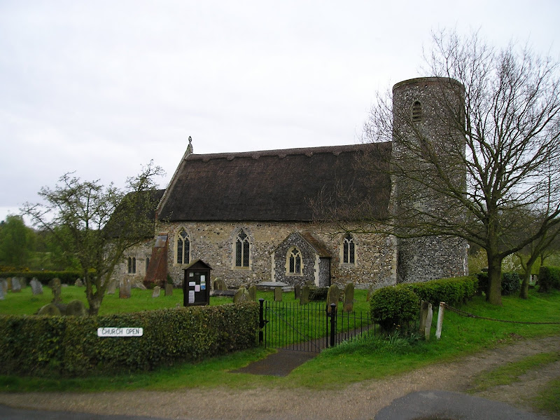
St Marys Church, HerringfleetView in OS Map | View in Google Map
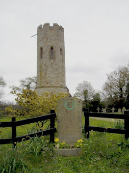
An interesting little church located in the fields between Fritton and Somerleyton. Its position is at the crossing of medieval tracks which have now become just footpaths and farm tracks so the best way to access the church is on foot. The church is built in a barn type construction with thatched roof whose roof timbers follow the shape of the branches from which they were made. It has an unusual tower that has a round base which turns to octagonal about three quarters the way up. There is no clear indication why this is constructed in such a manner. It may have been due to the original tower falling and then being remodelled though there is no documentation to confirm this. The church dates from the 13th century though the upper part of the tower dates from the 16th century and internal decorations being added from the 16th to the 19th century.
Gallery
Below are a selection of images taken from from the photo album for this walk. Feel free to browse through these or click on an image to view a larger version in the Gallery.


Summary of Document Changes
Last Updated: 2021-12-07
Angles Way, Distance:long, Features:Churches and abbeys, Features:Folklore, full-detail, OSmap:OL40, Riverside Walk, Suffolk


Your website is very beautiful or Articles. I love it thank you for sharing for everyone. Caravan Hire Robin Hoods Bay
ReplyDelete