East Suffolk Line Walk - The Yox Blyth Walk
|
Sunday 13 January 2019
|
No comments |
![]()

A 10 mile walk along the East Suffolk Line Trail between Halesworth and Darsham
Great views are to be had along the Blyth valley before footpaths head over to the Yox valley. The village of Bramfield is at the half way point where is an old pub for refreshments as well as a distinctive church with a detached tower and a fine example of a Crinkle Crankle Wall, not to mention the legendary Bramfield Oak.
East Suffolk Line Walk - The Yox Blyth Walk - Essential Information
Walk Statistics:
- Start location: Halesworth
- End location: Darsham
- Distance: miles ( km)
- Total Gain: ft ( metre)
- Total Descent: ft ( metre)
- Min Height: ft ( metre)
- Max Height: ft ( metre)
- Walk Time:
- Walk type: Linear
- Walk Grade: Easy
- Terrain:
Maps:
The following maps and services can assist in navigating this route. There are links to printed maps and links to downloadable GPX route data for importing into navigational software and apps.
- Ordnance Survey Explorer Map
- OS Explorer 231 - Southwold & Bungay
- GPX Route File
Transport:
Details of public transport that is required for the walk
National Express - Train Service
- Service Details
- East Suffolk Line - There is a two hourly service between Saxmundham and Lowestoft and an hourly service between Saxmundham and Ipswich
- Timetable
- http://www.eastsuffolkline.com
Route Verification Details
- Date of Walk: 2010-10-22
- Walk Time: 10:00 to 15:30
- Walkers: Griffmonster, Kat
- Weather Conditions: Autumn sunshine with clouds coming in from the west. Cool
Walk Notes
The East Suffolk Line Walks are a series of connected footpaths and country lanes that link the stations along the East Suffolk railway line that runs from Ipswich up to Lowestoft. There is a free booklet available online that documents each walk with this specific walk available as separate PDF document. The footpaths are marked with the distinctive circular East Suffolk Line Walk waymarkers that depict a windmill and church in a rolling landscape with a rising sun on the horizon. These provide a great way to explore the East Suffolk towns and countryside.
For this specific walk the train was caught from Darsham through to Halesworth which is no more than a 10 minute journey. The ticket can be purchased on the train and there is free parking at opposite the station albeit only limited spaces in the car park. Halesworth Station boasts the Halesworth and district museum on its platform which adds to the interest of the walk. Unfortunately on this instance of the walk it was closed although subsequent visit is planned.
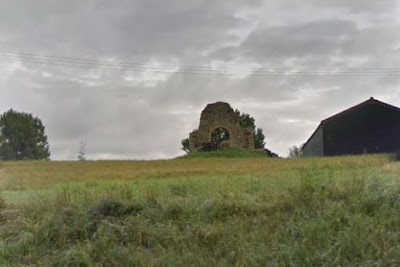
The walk starts at the Town Park on Saxon Way where an asphalt path leads along side the course of the River Blyth. This continues out of town and onto river side footpaths through to the road to the village of Mells. This is no more than a narrow country lane that leads across the Old Chapel Bridge and around the double bend through the picturesque village. As the lane leads out of the village, on the field above the bank on the left are the ruins of St Margaret's Chapel. There is no public access and the large window arch of the western side of the chancel is a false indication of the state of the ruins. In reality little remains apart from the flint and rubble walls of the chancel. This was built some time around AD1104 after which several attempts were made to make Mells, which was a hamlet within Wenhaston parish, a parish in its own right. Eventually Pope Honorius II resolved the matter in 1217 and ruled against such a status and as such there was no right of burial at the chapel. By the mid 15th century the chapel had fallen into disuse after which it was left to ruin. A full archaeological report that was prepare in 2007 can be found on the Archaeology Data Service website.
The route then cuts across open countryside through to the village of Bramfield where the Queens Head provides a convenient stopping off point for refreshments and food. The village has an intriguing church with a separated round tower which is located some yards south west of the main building. This gives the impression that an older church must have existed that was attached to the tower although there no evidence to support such a proposition. The tower dates from the 13th century and the tatched church the 14th century. of such with both the tower and church dating from the 13th century.
The final part of the walk cuts across more countryside to the ancient woodland of Kingstall Wood then turns south down to Yoxford. The village is full of old higgledy piggledy buildings and a unique road sign that stands in the churchyard on the corner of the road junction. This three fingered cast iron sign dates from the 19th century before the modern A12 releived traffic from the centre of the village. Open lettering points to Yarmouth, London and Framling’m under which there is a milage indicator.
There is a footpath that cuts across the grounds of Cockfield Hall to return to Darsham station.

Directions
The route is set out with the distinctive East Suffolk Line Walk waymarkers. Although these are abundantly placed, an OS map is needed for clarification.
Halesworth to Bramfield
The walk heads out of Halesworth through a park area, following the River Blyth through to Mells. From Mells take the road south and cross straight over at the T-junction to follow the track up to Melles Court Farm. Before the farm, bear left to the side of the trees. Continue until another path is met and turn left here down to a road at Bartholemews Farm. Turn right and continue until there is another path on the right by Westgate Farm. Take this which emerges on the edge of Bramfield. Continue straight ahead on the road into Bramfield, then left on the main road until the Queens Head pub is reached.
Bramfield to Darsham
Take the road down the side of the pub until it crosses the railway. Immediately after there is a path on the left which leads over to Kingstall Woods. Just beyond the woods, take the right as the footpath joins another, then take the first footpath on the left. This emerges on a road. Turn right, then take the next footpath on the left. At the next road, turn left and take the first footpath on the right. This eventually emerges on the main A1120 through Yoxford. Turn left and walk through the village. Just beyond the church there is a path on the left by the keepers cottage for Cockfield Hall. This cuts across to the A12 where there is a pavement up to Darsham station.

Pubs
The Queens Head, Bramfield: View in OS Map | View in Google Map

- Address
- The Queens Head, Bramfield:
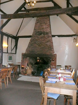
This Grade II Listed building, has stood at the centre of the small village of Bramfield for several centuries. Formerly known as "Skeletons" the traditional pub has evolved into an award winning dining pub renowned for its high quality, home-made meals produced from quality local and local organic vegetables, meat and fresh fish. The interior features scrubbed pine tables, exposed beams, huge fireplaces and a bar with a vaulted ceiling. The pub offers Adnams ales plus a variety of locally made produce available at the bar.
On entering this pub one cannot help to be impressed by the huge vaulted ceiling bar with the large open fireplace. Very friendly bar service with Adnams Bitter and Broadside on tap. The beer quality was top-notch and sandwiches were also excellent.

Features
The Bramfield OakView in OS Map | View in Google Map
A long lost landmark of Bramfield was a large oak tree affectionately known as the Bramfield Oak. This ancient feature had, for centuries, acted as a waymarker for travellers going between Framlingham to Bungay until the tragic day of 15th June 1843 when the mighty tree came crashing down unannounced.
Alfred Suckling records the event in his 1846 publication The history and antiquities of the county of Suffolk where, on page 172, he states
...in 1832 the 'king of the forest' had three main branches, the largest of which had fallen when the drawing was made by Mr Rabett [see image gallery], from which our illustration is engraved. It stood thus mutilated and scathed till the 15th June 1843, when on a calm sultry day, without a breeze to moan its fate, it fell from sheer decay, with a most appalling crash, enveloping its prostrate from with clouds of dust.
The tree had gained some notoriety in the fact that local folklore states that Queen Elizabeth I allegedly sat beneath its branches. However its greatest claim to fame was in an old ballad which told the tale of Earl Hugh Bigod fleeing from the wrath of Henry II in 1174, where, in the fifth stanza it records:
When the Baily had ridden to Bramfield oak
Sir Hugh was at Ilksall bower;
When the Baily had ridden to Halesworth cross
He was singing in Bungay tower
There is some debate as to whether the oak really was old enough for Hugh Bigod to have known it, but nonetheless there are local tales about Bigod hiding in the tree, although these are most likely just enriched folklore that has been borrowed from the famous tales of the Charles II who escaped capture in a similar manner.
Although now long gone, we can deduce its location from an extract in Robert Wakes 1839 publication Southwold and its vicinity, where on page 333 he records
Contiguous to the church stands the mansion of the very ancient Rabett family; and in the centre of the lawn, the very lightning scathed Bramfield oak
The mansion of the Rabett family is Bramfield hall which lies due south of the church with its parkland extending further south and through which the A144 road into the village passes. As this tree was said to be a waymarker for travellers then it must have been close to the course of the road. Even today large old trees dress the parkland, so one can easily imagine a faithful old oak standing there proud, pointing travellers in the direction of Halesworth and Bungay.
References
- The History And Antiquities Of The County Of Suffol, Suckling, Alfred Inigo, 1846, pp172-173
- The New Suffolk Garland, Ford, James, 1818, pp135-139
- Southwold and its vicinity, Wake, Robert, 1839, pp333
- Hidden East Anglia website reference for Bramfield
- Bramfield village website page, History of Bramfield
Holton Mill: View in OS Map | View in Google Map
Holton Windmill is a preserved Grade II listed open trestle post mill at Holton St. Peter and is visible from the path along the Blyth. Built in 1749, it was in constant use up to 1910 when it was used as a summerhouse. It then became derelict until 1949 when it was taken over by Holton Mill Preservation Fund Committee. Eventually preservation began in 1963
References
St Andrews Church, Bramfiled: View in OS Map | View in Google Map
The noticeable thing about St Andrews is its detached tower. This is the only example of a detached round tower in Suffolk, though there is a similar example at Little Snoring in Norfolk. There is no evidence that the tower was ever attached to the present church, which is 14th century and a more recent construction than the tower.
St Andrews has one of the best collections of headstops in the county and also exhibits a very well preserved green man on the eastern eaves of the nave. Bramfield was the site of a significant medieval shrine, and the recess for it survives. You can make out the outline of the wooden crucifix that once stood against the back of it, and there are faint surviving paintings of Angels of the Precious Blood around it.
References
Crinkle Crankle Wall, Bramfiled: View in OS Map | View in Google Map
Not many folk may even know what a Crinkle Crankle wall is, but opposite the church, the wall will speak for itself. It is in fact a wall with curving lines following a serpentine path rather than a straight line. This layout not only gives the construction added strength but also does away with the need for buttressing. This particular wall is a very fine example.
Cockfield Hall, Yoxford: View in OS Map | View in Google Map
Cockfield Hall is a Grade I listed private house standing in 40 acres of historic parkland, dating from the 16th century. A small attractive lodge cottage with decorative neo-Jacobean brickwork borders the High Street Entrance to Cockfield Hall. The hall was built by the Spring family, wealthy cloth merchants and later baronets of Pakenham. Lady Catherine Grey, sister of Lady Jane Grey, was imprisoned at Cockfield Hall in 1567 to recover from her privations in the Tower of London but died shortly after her arrival and was buried in the Cockfield Chapel in Yoxford church. Today the house is a Bed and breakfast.
References

Gallery
Below are a selection of images taken from from the photo album for this walk. Feel free to browse through these or click on an image to view a larger version in the Gallery.


Summary of Document Changes
Last Updated: 2021-12-07
Distance:Medium, East Suffolk Line Path, Features:Churches and abbeys, Features:Manor Houses and Halls, full-detail, OSmap:231, Suffolk


0 comments:
Post a Comment