South West Coast Path - West Bay to Abbotsbury
|
Saturday 9 February 2019
|
No comments |
![]()
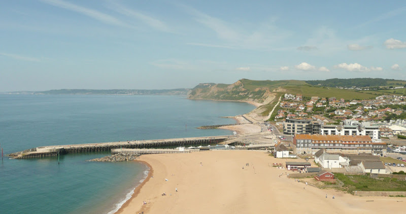
A 9 mile walk along the South West Coast Path between West Bay and Abbotsbury
One of the easier sections of the South West Coast Path as the cliffs taper down to present the start of Chesil Beach, a vast shingle bank that stretches from Abbotsbury through to Portland.
The climb out of West Bay is a steep ascent up to 45m and the summit of East Cliff. This is the only real challenge on this walk. The cliffs become notably smaller and the going becomes easier. At Buron Bradstock the path descends back down to beach level and follows the perimeter of a holiday park along the side of the River Bride to a bridge although the water looks shallow and placid enough to wade across as the river twists around the shingle and exudes across the beach.
By the time one gets to Codgen Beach there are no cliffs, just the beach that merges into the grassy landscape with an undulating hillscape beyond. Ahead Portland clearly shows itself. The path leads across the head of the beach and at times it is difficult going underfoot. It is a relief to head on the grassy paths that lead behind Burton Mere but it eventually leads back onto the shingle beach.
Beyond Bexington the path improves and continues through to where it heads inland to Abbotsbury, circling around the base of Chapel Hill, where St Catherines Chapel sits ominously on its summit. At this point the coast path doubles back on itself to continue on to Langton Herring. On this instance of the walk, with having to travel from Salcombe Regis using public transport, it left little time for walking. This is the furthest distance that was used from tht specific campsite, reloating to Langton Herring the next day. In retrospect it would have been more convienient to have undertaken this walk from the Langton Herring campsite.
The bus stop in Abbotsbury is outside the Illchester Arms, a 17th century former coaching inn that is well worth paying a visit, the interior welcoming and cosy with its oak beamed ceilings. The pub is said to be haunted and there are numerous ghostly tales associated with the inn including the sounds of coins jangling by a ghostly coin collector, a spectre of a woman who haunts the toilets and the apparition of a Royalist Soldier from the civil war who was reputedly hanged here when caught by Parliamentarians.
South West Coast Path - Charmouth to West Bay - Essential Information
Walk Statistics:
- Start location: West Bay
- End location: Abbotsbury
- Distance: miles ( km)
- Total Gain: ft ( metre)
- Total Descent: ft ( metre)
- Min Height: ft ( metre)
- Max Height: ft ( metre)
- Walk Time:
- Walk type: Linear
- Walk Grade: Moderate
- Terrain: Low cliffs to start eventually tapering out to beach walking
Maps:
The following maps and services can assist in navigating this route. There are links to printed maps and links to downloadable GPX route data for importing into navigational software and apps.
- Ordnance Survey Explorer Map
- OS Explorer 116 - Lyme Regis & Bridport
- GPX Route File
Accommodation:
Salcombe Regis CampsiteView in OS Map | View in Google Map
- Website
- www.salcombe-regis.co.uk/
- Description
- Situated at the head of the valley going down to Salcombe Mouth with some excellent views.
Transport:
Details of public transport that is required for the walk
Traveline - Bus Service
- Service Details
- At the time of walking the X53 Jurassic Coastlinx service provide a link between Abbotsbury, West Bay and the campsite at Salcombe Regis. This no longer appears to be the case. For the latest details of services and operators see the Traveline website
- Timetable
- https://www.traveline.info/
Route Verification Details
- Date of Walk: 2010-06-21
- Walk Time: 11:00 to 16:00
- Walkers: Griffmonster, Kat
- Weather Conditions: Bright sunshine and hot
Directions

Summary of Document Changes
Last Updated: 2021-12-07


0 comments:
Post a Comment