South West Coast Path - Osmington to Lulworth
|
Thursday 16 May 2019
|
No comments |
![]()
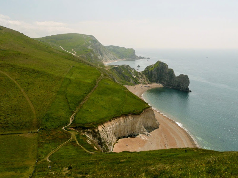
A 7 mile walk along the South West Coast Path From Osmington to Lulworth Cove
A spectacular but demanding walk along the Dorset section of the South West Coast Path. The huge undulating cliffs present challenges to overcome but the scenery is magnificent beyond doubt that will leave one gasping in awe. Probably one of the most iconic sections of the whole south West Coast Path culminating in familiar landmark of Durdle Door.
South West Coast Path - Osmington to Lulworth Cove - Essential Information
Walk Statistics:
- Start location: Osmington
- End location: Lulworth Cove
- Distance: miles ( km)
- Total Gain: ft ( metre)
- Total Descent: ft ( metre)
- Min Height: ft ( metre)
- Max Height: ft ( metre)
- Walk Time:
- Walk type: Linear
- Walk Grade: Strenuous
- Terrain: Footpaths
Maps:
The following maps and services can assist in navigating this route. There are links to printed maps and links to downloadable GPX route data for importing into navigational software and apps.
- Ordnance Survey Explorer Map
- OS Explorer OL15 - Purbeck and South Dorset
- GPX Route File
Accommodation:
Bagwell Farm Camp SiteView in OS Map | View in Google Map
- Website
- www.bagwellfarm.co.uk/
- Description
- Touring site close to the main road with easy access to the coast Path
Transport:
Details of public transport that is required for the walk
Traveline - Bus Service
- Service Details
- At the time of walking there was no bus service. This has since been rectified by the X54 First Group service that links lulworth Cove and Weymouth. The X53 service then links Weymouth and the campsite at Langton Herring. For the latest details of services and operators see the Traveline website
- Timetable
- https://www.traveline.info/
Route Verification Details
- Date of Walk: 2010-06-24
- Walk Time: 08:30 to 12:00
- Walkers: Griffmonster, Kat
- Weather Conditions: Bright sunshine and hot
Walk Notes
At only seven miles this walk may appear to be nothing more than an afternoon stroll. Do not be fooled. The cliffs wildly undulate with some challenging ascents and descents. From Osmington Mills the path steadily rises to nearly 170m at White Noethe after which there is a roller-coaster walk of steep descents and climbs over 100m cliffs. It is spectacular to say the very least and the scenery is some of the most photographed of the whole SWCP culminating in the iconic Durdle Door, an arched door eroded out of the cliffs. The descent from Swyre Head is very steep although there are footholds cut into the grassy hillside to enable walkers to grip their way up and down. Even so, as a vertigo sufferer it did not present too much of an issue, the grass covered slope providing a reassurance that this is not quite vertical!
On this occasion rambling along the top of the cliff around the summit of Swyre Head, an adder passed between our steps heading to the cliff edge. It disappeared into the grass camouflage and one could only wonder whether the snake had any knowledge about the sheer drop beyond.
The area around Durdle Door and Lulworth Cove is a very popular tourist destination that attracts large parties of schoolchildren on field trips. Consequently the area can be very busy with queues of folk along the path down into Lulworth Cove as was the case on this occasion. The benefit of this attraction is that the Cove has all the tourist facilities including the Hall and Woodhouse pub that has the rather obvious name of The Lulworth Cove Inn and this hostelry offers a decent range of ales as well as accommodation. The Grasshopper ale was a great reward for completing this strenuous hike.
Despite the huge number of tourists, public transport to the Cove is pretty scant. In fact when this walk was undertaken, the bus service was non-existent and an inland return route had been formulated in case we could not find a method of transport back. The public transport situation does appear to have been rectified in more recent times and there are now a few services that link back to Osmington and Weymouth. The only other option is a taxi to the town of Wool which is on the main bus route. As luck would have it, after a visit to the pub, a taxi pulled up in the car park to drop off a fare. A quick request to the driver and he had a new fare back up to Wool.
It should be noted that beyond Lulworth is a military range and the cost path through this is only open at specific times. If one wants to continue walking then consult the dates and times of public access.
Directions
Summary of Document Changes
Last Updated: 2021-12-07


0 comments:
Post a Comment