The Sandlings Walk - Knodishall to Sizewell Belts
|
Saturday 18 August 2018
|
No comments |
![]()
A 9 mile circular walk that links Knodishall and Sizewell Belts along Suffolk's Sandlings Trail
An easy walk across the typical heaths and commons of Coastal East Suffolk that make up the Sandlings. There is woodland, marsh, and rambling sandy heath full of flora fauna and wildlife.
NOTE: The section from Sizewell through to Leiston Common, Sizewell Belts is no longer part of the official Sandlings path. It has been rerouted along the beach in front of the power station and then through Kenton Hill woods. This Sizewell Belts walk as described here is still accessible using permissive paths.
The Sandlings Walk - Knodishall to Sizewell Belts - Essential Information
Walk Statistics:
- Start location: Leiston
- Distance: miles ( km)
- Total Gain: ft ( metre)
- Total Descent: ft ( metre)
- Min Height: ft ( metre)
- Max Height: ft ( metre)
- Walk Time:
- Walk type: Circular
- Walk Grade: Easy
- Terrain:
Maps:
The following maps and services can assist in navigating this route. There are links to printed maps and links to downloadable GPX route data for importing into navigational software and apps.
- Ordnance Survey Explorer Map
- OS Explorer 212 - Woodbridge & Saxmundham
- GPX Route File
Route Verification Details
- Date of Walk: 2018-08-18
- Walk Time: 10:30 to 15:00
- Walkers: Griffmonster, Kat
- Weather Conditions: Warm spring day with plenty of sunshine but a rather cool coast breeze
Walk Notes
This walk offers walking across a landscape that is typical of the Sandlings area. From Leiston it follows the road to Coldfair Green, commonly refereed to as Knodishall although up until the 1980s it had been part of Leiston parish and had no connection with Knodishall. Just out of the village a track leads up past the 17th century timber and plaster walled Billeaford Hall. Small woodlands dot the area with interesting names such as Five Acre Pickle and Portabello Covert. The interesting name of pickle is most likely a middle English term derived from pyghtle with a meaning of a portion of land picked off from a larger field. Indeed this section of woodland is no more than a short strip of land from the field beyond and has certainly been that way since before the late 1800s when OS maps were first produced. The lane alongside this is Nuttery Lane and this passes more woodland on the left which is known as Nuttery Spong and in springtime tit is a riot of colour when the bluebells carpet the ground. Unfortunately the landowner has made it clear that these woods are now out of bounds with many signs informing that the area is private ground. The name Spong can also be traced back to Middle English also meaning a narrow strip of land. Although the woods now cover a substantial area, originally it was only a narrow strip of woodland occuying the western side of the present area.
Keep heading for the radio mast and then past this and downwards to the main road. Behind the thick hedgerows, in a field on the right is the remains of Hazelwood Chapel, the former church to the parish of Hazelwood, which no longer exists. It is difficult to see the ruins, especially with a crop in the field. Do not attempt to gain access as the landowner is strongly against anyone walking across his land and the numerous posters warning of trespass on the track up to Chapel Farm bear testament to this fact. This area is extensively used for youngsters out on their Duke of Edinburgh challenges and it would appear that more than a few have strayed onto this land and met the fiery wrath of the landowner.
The walk crosses the road into the area known as North Warren Nature Reserve. This consists of heathland to the right and wetland commonly known as The Fens to the left. The path eventually leads into woodland and onto the former Aldeburgh branch line. The track was lifted decades ago and this is now a very popular route for walkers between Thorpeness and Aldeburgh. The railway passes over the Hundred river, the ancient boundary marker with Plomesgate hundred to the south and Blything hundred to the north. The little further on where there is a bench on the left is the location known as Sheepwash Crossing which would have been a crossing point of, presumably, sheep tracks over the railway. The crossing keepers cottage still stands just beyond and the public footpath continues behind it. One can empathize that this may have been the location where shepherds washed their flocks by night all seated on the ground.
The public footpath runs parallel to the old railway, behind what was the station platform now virtually hidden in the undergrowth. It then crosses the road alongside the railway, eventually leading off to the right on a very sandy track down that leads through the commons and heathland to Sizewell Hall and out onto the road.
As noted at the start of this write-up, the Sandlings has changed its route at this point. The original route took the track from Sizewell to Leiston Common and then proceeded across the marsh area known as Sizewell Belts. This section has been rerouted along the beach in front of the power station and up through Kenton Hill Woods. The new route has been marked on OS maps for some considerable time and both routes appeared to coexist for many years. Even when the Sandlings logo changed in 2011 and new waymarkers were added to the trail across Sizewell Belts, confusing the humble walker as the OS map begged to differ as it depicted the coast route. This was so perplexing that one never knew which route was the official route or whether they were just alternative paths.
In August 2018 the situation appears to have been clarified when the area was given new signs and the Sandlings waymarkers adjusted to point to the beach route. This has certainly cleared up all ambiguity as to the official route and hopefully it prevents the bewilderment of many more hikers who attempt to follow the trail. Even so, the old route can still be accessed and this specific walk is still a valid and a going concern for those who prefer to walk a more typical Sandlings landscape rather than the beach.
It is uncertain why the route ever changed in the first place as the Sizewell Belts alternative certainly appears to be more in keeping with the landscape typified by the Sandlings. One may argue that it uses permissive paths across the Sizewell Estate and the new waymarkers on this route now explicitly state this fact. Access to such routes is subject to the landowners prerogative and can be blocked up without notification. However the land covered by Kenton Hill Woods is also part of the Sizewell Estate and these paths are also permissive, therefore such an argument does not stand up.
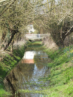
Whatever the cause for the re-routing, the old route as described here is well worth walking. It is fully accessible, it is waymarked with footpath and permissive path markers and offers a richer landscape to walk through than the coastal route. The route starts as a track across ancient heathland, the track itself said to date from medieval times and was, until the 19th century, the main route between Leiston and the coast. A permissive footpath then crosses Leiston Common, before descending down to the marshland known as Sizewell Belts. The well trodden path is easily followed and proceeds into Kenton Hill Woods to meet back with the coastal route.

Directions
The walk is well waymarked with the distinctive Sandlings markers.
The path is picked up on the southern side of Knodishall as a track leading eastwards up a hill across arable farmland. Keep to the track, turning left by a wooded area known as Five Acre Pickle and head round to the radio mast where the track passes by the buildings and down to the Aldeburgh Road. Cross over the road and head over the heathland with The Warren to the right and The Fens to the left. The path enters more woodland and onto the former Aldeburgh railway. When the path emerges to an open area which used to be the old station, turn right and follow the path around the back of the house. Keep to this path, past the golf course on the right and over the road onto a surfaced track. This soon bends round to the right and becomes a sandy lane which leads through to Sizewell. The Beach View bar can be found by taking the footpath by Sizewell Hall to the coast, turn left and the entrance is 100 yards along the top of the dunes.
Returning back to the path, continue to the Sizewell road and cross over onto another sandy track a few yards up the road. Just before the houses at the end of the track there is a footpath on the left which leads round the back of the Wind Farm substation and out across Broom Covert, usually home to grazing cows. At the end of the covert there is a style back onto a track. Where this junctions with another track take the footpath directly opposite down the side of the house and up to Leiston Common. Follow the markers across the common, heading to the right of the cottages on the far side where there is a steep hill down to Sizewell Belts. This can be marshy in wet conditions. The path leads across the Belts and up into Kenton Hill woods. Follow the Sandlings markers through to the far end of the woods where it emerges onto the track to Eastbridge.
To return to Leiston, turn left on the track then head down the hill on the road where there is a footpath that leads onto Valley road in Leiston.
Features
Blything HundredView in OS Map | View in Google Map
The River Hundred passes through the parish of Knodishall and then feeds into Thorpeness Mere. The name of the river is taken from the fact that it formed the boundary to the Saxon hundreds of Blything and Plomesgate. The hundreds were land divisions set up around the 10th century and the name is thought to be a reference to the number of hides or units sufficient to support one family. The name of the hundred is usually derived from the outdoor meeting place that was the location of the old Hundred court. Blything Hundred covered the area bounded by the hundred river in the south to the Hundred river at Benacre in the north and Rumburgh in the west with its centre of administration based at the hall of the ancient royal estate of Blythburgh.
On the southerly side of the Blything Hundred is the village signed as Knodishall. This is, in fact, the hamlet known as Coldfair Green, Knodishall being a tiny hamlet west of this. On Hodskinsons map from the 1780s Coldfair Green is given the name Coldford Green and was the location of a ford across the Hundred River linking Leiston with Snape. The name change is thought to have occurred in the late 1800's when an annual fair was held in the village. This custom died out in the early part of the 20th century but has more recently been revived.
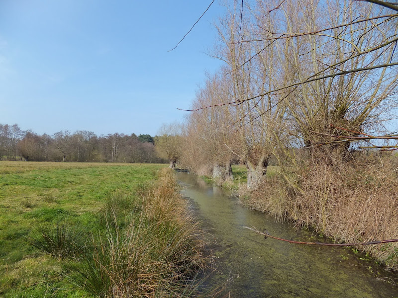
Sizewell BeltsView in OS Map | View in Google Map
Sizewell Belts is an area of marsh, reedbed and wet woodland located to the north west of Sizewell Power Station and owned by the nuclear industry. Originally a wild reed marsh, the area was drained in the 18th century. Today the area is designated as a Site of Special Scientific Interest and is managed by the Suffolk Wildlife Trust who use cattle grazing nd traditional hay making to control the meadow vegetation along with annual willow pollarding, a technique of pruning to restrict the height and extend the life of the tree. The maze of dykes are cleaned out on a rotation basis to ensure that ensures a variety of vegetation development and diversity of habitat is always on show.
The site is one of the best wetlands in East Anglia for wildflowers including orchid, yellow rattle, ragged-robin, bogbean and lady’s smock and is home to otters, water voles and kingfishers.

Links and Bibliography:
Gallery
Below are a selection of images taken from from the photo album for this walk. Feel free to browse through these or click on an image to view a larger version in the Gallery.


Summary of Document Changes
Last Updated: 2022-04-19
Circular Walk, Distance:Medium, Features:Flora and Fauna, Features:Local History, full-detail, OSmap:212, Sandlings, Suffolk


0 comments:
Post a Comment