In Search of the Lost City of Dunwich
|
Tuesday 7 January 2020
|
No comments |
![]()
A circular walk between Leiston and Dunwich
This walk uses the beach and the Sandlings Path to provide a days walk to Dunwich from Leiston via Sizewell. One should time this walk such that the beach is walked a couple of hours either side of low tide when there is a little sand to walk along. At other times the beach is predominantly shingle and the walker may find it easier to follow the Suffolk Coast Path which is waymarked from the north side of Minsmere where it continues up onto the cliffs.
Leiston to Dunwich Walk - Essential Information
Walk Statistics:
- Start location: Leiston
- Distance: miles ( km)
- Total Gain: ft ( metre)
- Total Descent: ft ( metre)
- Min Height: ft ( metre)
- Max Height: ft ( metre)
- Walk Time:
- Walk type: Circular
- Walk Grade: Easy
- Terrain:
Maps:
The following maps and services can assist in navigating this route. There are links to printed maps and links to downloadable GPX route data for importing into navigational software and apps.
- Ordnance Survey Explorer Map
- OS Explorer 212 - Woodbridge & Saxmundham
- GPX Route File
Route Verification Details
- Date of Walk: 2016-08-07
- Walk Time: 10:30 to 16:30
- Walkers: Griffmonster, Kat
- Weather Conditions: Summers day walk with lots of sunshine
Walk Notes
Dunwich is one of those places that are full of intrigue and mystery. The town was once the largest in East Anglia but was taken by the sea over the centuries. At its height, the town was a busy port on the mouth of the River Dunwich that brought wealth to its citizens from shipbuilding, fishing and the wool trade. Then came the storms that ravaged this part of the coast and blocked up the harbour and the erosion which left the majority of the town beneath the waves.
There is still a lot to discover and the first place for any discovery about the history of the area is to visit the museum which is just up the road from the Ship Inn. The museum is open from March to October and provides the visitor with the full history of this once important place. It is highly recommended.
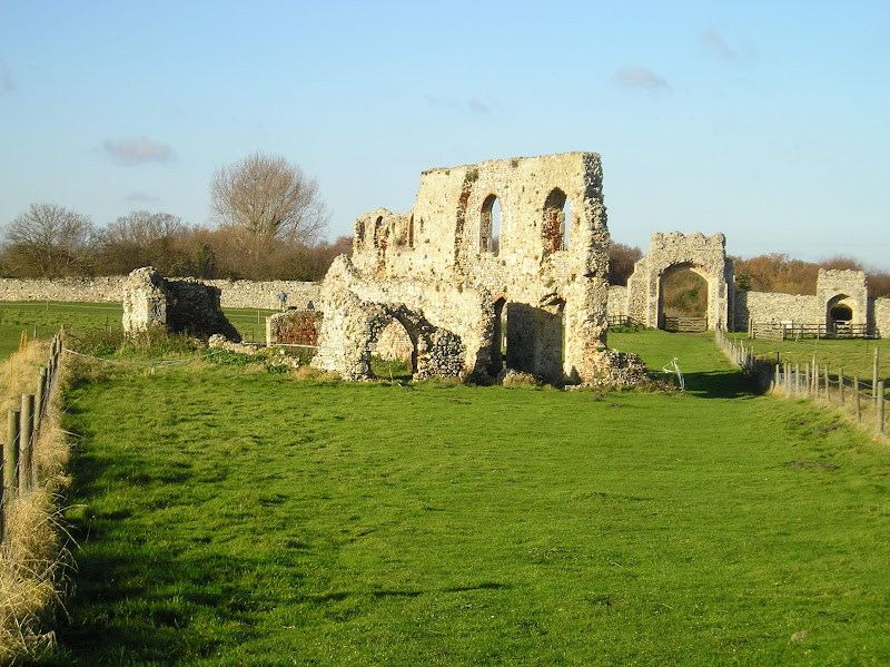
There are also a lot more reminders of the town including the ruins of Greyfriars Friary that sits atop the cliffs to the south of what remains of the village. This Franciscan friary dates from the 13th century and lasted up in the dissolution of the monasteries in 1538.
On the cliff ward side of the Friary is the last gravestone that remains from what was All Saints churchyard. The church was abandoned in 1755 as coastal erosion started to threaten its existence. The building eventually toppled over the cliff in the early 20th century and erosion has been gradually eating away more of the land which was once the graveyard. There are many reports of human remains hanging out of the cliffs over the years. Just one gravestone remains and a viewing point has been added in recent years to prevent inquisitive passers by from trampling down the fence that boarded the path.
The present church of St James that is located on the western edge of the present day village was constructed to replace All Saints and the churchyard bears a reconstructed buttress from All Saints.
There is so much more to tell about this interesting area.
Directions
The route uses The Sandlings and the Suffolk Coast path to make a circular walk with the start/end at Sizewell with alternative routes via Kenton Hill woods and Leiston.
Sandlings Path
From Sizewell take the track opposite the lane to Sizewell Hall which heads towards the west side of the power station. Before it reaches the cottages a footpath branches off to the left. This passes woodland and the new Greater Gabbard Windfarm onshore substation. Pass through open fields and back down onto Sandy Lane. A path goes up to the right of the cottages here and up onto Leiston Common. Cross the common and continue down across Sizewell Belts and up into Kenton Hills Woods. Marker posts lead through to the visitor car park where a track leads through to the Eastbridge road. At the end of the track turn right, pass through Eastbridge and along the road until it turns a sharp right. Continue round the bend and when the road bears another right there is a track up through the woods. Take this up over open pastures, across a road and through more woodland and heathland. Keep a lookout for the Sandlings waymarker which will direct you off to the right. The path ahead can be followed if you want to omit Dunwich Heath from the walk. At Dunwich Heath the path doubles back on itself just before the toilet block and rejoins the path you were on earlier. Turn right and follow through to the road to Dunwich Heath. Cross over the road and through the woods until it leads out onto another road. Turn right and where the road bears to the left continue straight on down the track with the cottages on the right. Follow the way markers through the woods and past the Friary ruins and eventually it comes out in Dunwich village.
Alternative Sandlings Route: For a shorter route you can follow the original Sandlings route through Goose Hill and Kenton Hill woods. There is a waymarker on the dunes just north of the power station, this will lead you across a bridge into the woods from where there are a variety of paths to take you back up to the car park.
Suffolk Coast Path
From Dunwich return the way you came past the Friary ruins and through the woods all the way back to the road to Dunwich Heath. Cross over and continue until a way marker directs you left off this path and all the way to Dunwich Heath. Here the path will lead down to the beach and dunes from where it continues all the way back to Sizewell.
Alternatives Beach Route: At low tide, when there is a little sand revealed, the beach can be walked all the way between Dunwich and Sizewell. Even at high tide it is walkable but the section between Dunwich and Dunwich Heath is particularly arduous as it is all shingle.
Leiston extension
From the Cliff House camping site a path leads west to Sizewell Hall. Turn right, then left on a farm track by the yellow cottage. At the end of this track turn right along a footpath through to Halfway Cottages. Here, bear round to the left then turn right across the fields towards a house at the far end. A farm track (Grimsey Lane) leads through to Leiston. At the main road turn right and follow the road through the town to Barclays Bank, turn right into Valley Road, and follow this until just after the railway bridge. A footpath on the left will lead you out to the main Sizewell Road from where you can walk either way to rejoin the Sandlings route.
Pubs
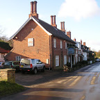
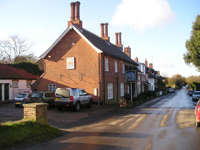
The Ship, Dunwich View in OS Map | View in Google Map
- Address
- The Ship, Dunwich
- Website
- https://www.shipatdunwich.co.uk/
The Ship is part of a portfolio of inns, restaurants and hotels owned and managed by Agellus Hotels Limited which specialises in distinctive properties offering quality food and accommodation and guest ales.
This 16th century Inn was previously known as The Barnes Inn after the family that once owned the village. There is a roaring wood fire in winter, and a garden complete with a 300 year old knarled fig tree for the summer. The pub offers the usual Adnams ales as well as regularly changing guest ales from a local small Suffolk or Norfolk brewers including Mauldons, Blackfriars and Earl Soham.
The pub is said to be home to a ghost in the attic room. A tale told by a previous owner relates how one dark night she awoke to find a mysterious ghostly figure sitting on the end of her bed. The figure got up and walked through the wall. To add to the intrigue, years later it was found that there was a hidden door in this wall which led to another room which the landlord had no previous knowledge of.
The pub garden in summer is a great place to pass an hour. Busy, but the beer is excellent, the Green Jack beer being a real thirst quencher.

Features
History of DunwichView in OS Map | View in Google Map
There are many tales to tell of the lost city of Dunwich. They say that it was from here that St Felix, the first Bishop of Dunwich, converted East Anglia to Christianity and local folklore proudly states that Dunwich was the capital of all of East Anglia. We do know, as there are records to that effect, that in the 11th century Dunwich was a thriving port. In those times Dunwich used to sit at the end of a shingle spit which started at Southwold and led the River Blyth south, merging with the River Dunwich and out to the open sea. This formed a natural harbour and was the reason Dunwich became such a prominent port and reputedly the tenth largest place in England, half the population of London. Depending on what text is read, the number of churches in the town during the 11th century varies though folklore would have it known it was as many as 12. The town also had a mint and a large guildhall and many houses of great importance and a population estimated to be as great as 5000.
The first recorded evidence that the town was being ravaged by erosion from the sea was recorded in the Domesday book when over half the taxable farmland was lost to the sea between 1066 and 1086. During the 13th century, two town suffered greatly during two great storms just over a year apart. The first on 1 January 1286 swept much of the town into the sea and partially silted up the River Dunwich; this was followed by a storm surges that affected much of southern England in February 1287. Although the residents fought hard to open up the harbour, another storm in 1328 shifted the shingle and effectively blocked it up for good. To add to the woes of the Dunwich people, yet another storm in 1347 swept another 400 houses into the sea and the rest of Dunwich slowly succumbed over the next 200-300 years.
When the last church, All Saints, was abandoned in 1755 as it got closer and closer to the cliff edge, a new church was built. St James church was completed in 1832 and still stands in the village and is the last of the many churches of Dunwich. All Saints church fell to the sea between 1904 and 1919 and all that is now left is a single gravestone standing on the cliff edge in front of the ruins of Greyfriars Priory. The inscription upon it reads In memory of Jacob Forster - Died March 12th 1796, Aged 38
. The incumbant to this grave was a merchant seaman who died prematurely whilst plying his trade. The period of time that he lived through must have been a constant danger for a merchant sailor with an almost constant state of war between the Birtish, Dutch and French with the Seven Years War (1756–1763), Fourth Anglo-Dutch War (1778–1783) and the French Revolutionary Wars (1793–1802) all taking place during his short life. Even so, he must have been well regarded in area for he was an elector of Southwold, a title that was only given to the wealthy or those with property.
Behind this grave, hidden in the undergrowth is a stump, the remains of another stone with just an inscription that relates,
Reader depart not from this stone
Till you have pondered where I am gone.
Death quickly took my breath away
And laid me in this bed of clay.
This stone once commemorated John Forster, no doubt a relation to Jacob. The full inscription once read:
JOHN FORSTER, died 22nd June 1798, Aged 47 Years
It is interesting to note the date on both of these stones is beyond that of when the church had been abandoned. In fact records from 1874 show that the graveyard were in use until at least 1836 when 75 year old Robert Gayford was interred.
Greyfriars was a Franciscan friary founded by 1277. Its original location was near the 11th century seafront but coastal erosion forced it to move to its present site in 1290. It's end came with the dissolution of the monastries in 1538. Surviving remains include the precinct wall with two gatehouses in excellent condition, and the South range of the cloister, possibly the refectory.
One legacy of Dunwich's past prominence was that up until the Reform Act of 1832 the parliamentary constituency of Dunwich retained the right to send two members to Parliament. When the constituency was abolished there were just 8 residents left in the constituency, represented in parliament by two MPs. The freemen of Dunwich had passed on their honour to their descendants who had moved away to other parts. At the end of the 18th century it has been said that people travelled to Dunwich on election day and then went out in a boat to the point where the town hall used to be, to cast their vote. Such a state of affairs was commonly known as a Rotten Borough and this was satirised in an episode of the Blackadder the Third titled Dish and Dishonesty. Named Dunny-on-the-Wold, it had a population of three cows, a dachshund called 'Colin', and 'a small hen in its late forties' and only one person who was the voter.
Dunwich does retain its ghostly reminders of a once great city. It is said that on dark and stormy nights if one listens very carefully you can hear the lost church bells ringing out from under the waves. In more recent times archaeological divers have reported the sensation that they are not alone as they investigate the subterranean ruins. And if you dare to venture along the beach on dark moonless nights you may very well encounter one of the ghostly apparitions that haunt this area; there are many accounts of a phantom sailor dressed in Elizabethan garb who crosses the beach and wades into the water before climbing into a small boat and vanishing into darkness. A tale I have heard first-hand tells of a group of fishermen who were on an all night fishing match on Dunwich beach. They all reported seeing a couple walk past them, their steps crunching on the shingle. The last fishermen at the southerly end watched them walk past heading towards Minsmere. He turned his attention back to his line when the steps abruptly stopped. He looked around and there was noone there, just the sea and the shingle and the cliffs with no other route away from the beach. Even today he lacks an explanation for these phantom walkers who just disappeared. One last mention, up at the ruins of Greyfriars, if you dare to venture there late at night it is said that you can hear the ghostly chants of long dead monks.
References
- Facebook group Rural East Suffolk In Old Photographs with post from Jacob Forster's descendant
- Monuments In The Churchyard Of All Saints, Dunwich, Transcribed By Rev.Francis Haslewood, Hon.Sec, article taken from publication below
- Proceedings of the Suffolk Institute of Archæology and Natural History by Suffolk Institute of Archæology and Natural History, 1874
- Website - Dunwich, the search for Britains Atlantis
- Official website for History of Dunwich
Dunwich MuseumView in OS Map | View in Google Map
To compliment the stories about the history of Dunwich it is always worthwhile visiting the villages small museum. This delightful and charming cottage based museum has many artefacts that tell the story of a city lost to the sea from the first millennium to the present day. A detailed model shows you what Dunwich was like at the height of its powers in the 13th Century, and the many exhibits cover Roman, Saxon, Medieval, Elizabethan, Jacobean Georgian and Victorian periods. The people of Dunwich run the museum on a purely voluntary basis and they are very knowledgable in the history so can give you a fascinating insight to add life to the exhibits on show. It is open from spring to autumn and admission is free, although there is a donation box to help with the funding.
References
Gallery
Below are a selection of images taken from from the photo album for this walk. Feel free to browse through these or click on an image to view a larger version in the Gallery.


Summary of Document Changes
Last Updated: 2021-12-07
Circular Walk, Coast Walk, Distance:long, Features:Local History, Features:Museums, full-detail, OSmap:212, Sandlings, Suffolk, Suffolk Coast Path


0 comments:
Post a Comment